Plan de Valparaíso
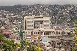
View of the National Congress of Chile located in the Plan.
The Plan de Valparaíso is the name given to the flat part of Valparaíso, Chile, where public and commercial buildings are found, distinguishing it from the hills (cerros) where the majority of the population live.[1]
Traditionally, the plan is divided into sectors Barrio Puerto, originally the nucleus of the city, and El Almendral, a preferentially dedicated trade zone.
References
- ↑ Ciudad de Valparaíso. "El habla de los porteños:- ¿Cómo dijo?". Retrieved June 2, 2015.
Coordinates: 33°2′35.56″S 71°37′22.25″W / 33.0432111°S 71.6228472°W
This article is issued from Wikipedia - version of the 11/30/2016. The text is available under the Creative Commons Attribution/Share Alike but additional terms may apply for the media files.