Piz Zupò
| Piz Zupò | |
|---|---|
|
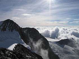
Piz Zupò seen from Piz Argient | |
| Highest point | |
| Elevation | 3,996 m (13,110 ft) |
| Prominence | 405 m (1,329 ft) [1] |
| Parent peak | Piz Bernina |
| Listing | Alpine mountains above 3000 m |
| Coordinates | 46°22′06″N 9°55′52″E / 46.36833°N 9.93111°ECoordinates: 46°22′06″N 9°55′52″E / 46.36833°N 9.93111°E |
| Naming | |
| Translation | Hidden peak |
| Geography | |
 Piz Zupò Location in the Alps | |
| Location |
Lombardy, Italy Graubünden, Switzerland |
| Parent range | Bernina Range |
| Climbing | |
| First ascent | 9 July 1863 by L. Enderlin and Serardi, with Badrutt |
| Easiest route | SW ridge (F) |
Piz Zupò (3,996 m) is a mountain in the Bernina Range of the Alps, located on the border between Switzerland and Italy. It lies between the valleys of Morteratsch (Graubünden) and Malenco (Lombardy). Piz Zupò is the second highest peak in the range after Piz Bernina.
The first ascent of the mountain was made by L. Enderlin and Serardi, with Badrutt (a chamois hunter) on 9 July 1863.
See also
References
- Collomb, Robin, Bernina Alps, Goring: West Col Productions, 1988
External links
| Wikimedia Commons has media related to Piz Zupò. |
This article is issued from Wikipedia - version of the 1/24/2016. The text is available under the Creative Commons Attribution/Share Alike but additional terms may apply for the media files.