Piz Cengalo
| Piz Cengalo | |
|---|---|
|
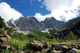
Piz Cengalo (left) and Piz Badile (right) from the north side | |
| Highest point | |
| Elevation | 3,369 m (11,053 ft) |
| Prominence | 620 m (2,030 ft) [1] |
| Isolation | 5.8 km (3.6 mi) [2] |
| Parent peak | Monte Disgrazia |
| Listing | Mountains of Switzerland |
| Coordinates | 46°17′41.1″N 9°36′07.4″E / 46.294750°N 9.602056°ECoordinates: 46°17′41.1″N 9°36′07.4″E / 46.294750°N 9.602056°E |
| Geography | |
 Piz Cengalo Location in the Alps | |
| Location |
Lombardy, Italy Graubünden, Switzerland |
| Parent range | Bregaglia Range |
| Geology | |
| Mountain type | Granite |
| Climbing | |
| First ascent | 25 July 1866 D. W. Freshfield and C. Comyns Tucker with guide F. Dévouassoud |
| Easiest route | West Ridge (PD) |
Piz Cengalo (3,369 m) is a mountain in the Bregaglia range of the Alps on the border between the Swiss canton of Graubünden and Italy. The first ascent of the mountain was by D. W. Freshfield and C. Comyns Tucker with guide F. Dévouassoud on 25 July 1866.[3] The name 'Cengalo' derives from Tschingel, meaning girdle.
On 28 December 2011 c. 1.5 million cubic metres of rock broke away from the summit area, causing a massive landslide on the Swiss side of the mountain that could be heard in Soglio and Bondo.[4][5] As subsequent massive rockfalls are expected in the same area, some hiking and climbing routes have been closed.
References
- ↑ Retrieved from the Swisstopo topographic maps. The key col is the Passo di Zocca (2,749 m).
- ↑ Retrieved from Google Earth. The nearest point of higher elevation is west of the Cima di Castello.
- ↑ Collomb, Robin G., Bregaglia West, Goring: West Col Productions, 1984
- ↑ "Fast unbemerkt: Riesen-Bergsturz im Bergell", tagesschau.sf.tv, 3 January 2012. Accessed 9 May 2012
- ↑ "Enormous landslide goes by unreported", worldradio.ch, 4 January 2012. Accessed 9 May 2012
External links
This article is issued from Wikipedia - version of the 1/3/2016. The text is available under the Creative Commons Attribution/Share Alike but additional terms may apply for the media files.