Piz da la Margna
| Piz da la Margna | |
|---|---|
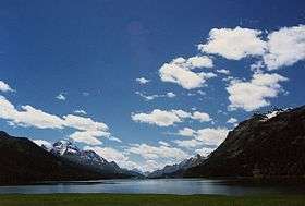 Piz da la Margna (left) and Lake Sils | |
| Highest point | |
| Elevation | 3,159 m (10,364 ft) |
| Prominence | 273 m (896 ft) [1] |
| Parent peak | Piz Bernina |
| Coordinates | 46°22′55″N 9°43′48″E / 46.38194°N 9.73000°ECoordinates: 46°22′55″N 9°43′48″E / 46.38194°N 9.73000°E |
| Geography | |
 Piz da la Margna Location in Switzerland | |
| Location | Graubünden, Switzerland |
| Parent range | Bernina Range |
| Climbing | |
| First ascent | June 1857 by J. Caviezel, Krättli, Robbi and Zaun |
| Easiest route | East flank (F) |
Piz da la Margna (3,158 m) is a mountain in the Bernina Range of the Alps, overlooking Lake Sils in the Swiss canton of Graubünden. It lies to the south-east of the Maloja Pass at the south-western end of the Engadin valley.
Ascents can be made from Maloja via the north ridge (F); a slightly easier route is via the Val Fedoz and the east flank. The south-east ridge from the Fuorcla da la Margna (AD, IV) was first climbed by Hans Frick, Christian Zippert and Hans Casper on 14 August 1918.[2]
The first recorded ‘tourist’ ascent of the mountain was made by J. Caviezel, Krättli, Robbi and Zaun in June 1857.[2]
References
External links
- Piz da la Margna on Summitpost
- Piz da la Margna on Hikr
- Webcam looking towards Piz da la Margna
- Nächtliche Winterlandschaft mit Piz da la Margna (painting by Giovanni Giacometti, 1913)
This article is issued from Wikipedia - version of the 5/8/2016. The text is available under the Creative Commons Attribution/Share Alike but additional terms may apply for the media files.