Piz Aul
| Piz Aul | |
|---|---|
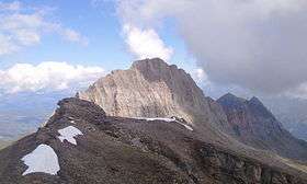 View from Faltschonhorn (south side) | |
| Highest point | |
| Elevation | 3,121 m (10,240 ft) |
| Prominence | 395 m (1,296 ft) [1] |
| Parent peak | Rheinwaldhorn |
| Coordinates | 46°37′22.1″N 9°7′28.2″E / 46.622806°N 9.124500°ECoordinates: 46°37′22.1″N 9°7′28.2″E / 46.622806°N 9.124500°E |
| Geography | |
 Piz Aul Location in Switzerland | |
| Location | Graubünden, Switzerland |
| Parent range | Lepontine Alps |
| Climbing | |
| First ascent | Probably by one Christian Janken. First recorded ascent by Placidus a Spescha in 1801.[2] |
Piz Aul is a mountain of the Lepontine Alps, overlooking Vals in the canton of Graubünden.
References
- ↑ Retrieved from Google Earth and from the Swisstopo topographic maps. The key col is located between Piz la Capiala and Piz Conteschas at 2,726 metres.
- ↑ Manfred Hunziker: Clubführer Bündner Alpen 2, Swiss Alpine Club, 1996, p. 209
External links
This article is issued from Wikipedia - version of the 5/8/2016. The text is available under the Creative Commons Attribution/Share Alike but additional terms may apply for the media files.