Pitt Lake
| Pitt Lake | |
|---|---|
| Location | British Columbia |
| Coordinates | 49°25′N 122°33′W / 49.417°N 122.550°WCoordinates: 49°25′N 122°33′W / 49.417°N 122.550°W[1] |
| Type | Fjord lake |
| Primary inflows | Pitt River |
| Primary outflows | Pitt River |
| Basin countries | Canada |
| Max. length | 24 km |
| Max. width | 4.5 km |
| Surface area | 53.5 km² |
| Surface elevation | 3 m[2] |
| Islands | Goose, Little Goose, Gosling |
| References | [1] |
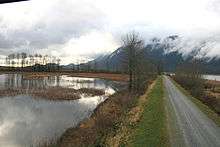
Pitt Lake is the second-largest lake in the Lower Mainland of British Columbia, being about 53.5 square kilometres in area. It is about 25 km long and about 4.5 km wide at its widest, and is also one of the world's largest tidal lakes, its confluence with the Fraser being only a few miles upstream from that river's estuary into the Strait of Georgia. Its southern tip, where the Pitt River resumes, is 40 km east of Downtown Vancouver.
The upper Pitt River valley is a typical U-shaped glacial valley in the Coast Mountains of British Columbia. The overdeepening of the lower end of the valley over the span of the Wisconsin glaciation created a trough over 140 m below current sea level. After initial glacial retreat at around 13,000 years ago a saltwater fjord occupied this basin when relative sea levels were still ca 120 to 140m above current levels in the region. Unlike neighbouring Indian Arm and Howe Sound farther west this fjord basin became cut off by sedimentation of the lower Fraser River by ca 10,500 years ago and is now considered a tidal fjord lake.
The community of Pitt Meadows occupies the marshy lowland at the southern end of the lake, some of which has become drained and is known as the Pitt Polder. Just southwest of the lake is the community of Port Coquitlam, which is across the Pitt River from Pitt Meadows. At the north end of the lake is a locality named Alvin, which is a transport and shipping point for logging companies and their employees. The Upper Pitt, meaning the valley upstream from the lake, is considered one of BC's best fly-fishing rivers and one of its best steelhead streams.
The lake is popular with boaters and canoeists, but is prone to heavy winds and rains as well as big waves (due to its great depth). The mountain range on its east flank comprises Golden Ears Provincial Park, its basin to the north is in southern Garibaldi Provincial Park, while the mountain range on its west, northeast of Vancouver's Coquitlam Lake watershed reservoir, is Pinecone Burke Provincial Park. The waterfront and foreshore of the lake and river are public-access and include extensive migratory wildfowl habitat. Part of it is protected by BC Parks as the Pitt Polder Ecological Reserve. There is a destination golfing resort in the Pitt Polder area called Swan-e-set. Also at the south end of Pitt Lake, adjacent to the Polder, is Pitt Lake Indian Reserve 5.[3]
It is the second-largest lake in the Lower Mainland. The largest is Harrison Lake, 60 km east, which is the last in a series of north-south lake and river combinations that line the north bank of the Fraser River in its last stretch west through BC's Lower Mainland. Others are those of the valleys of the Coquitlam, Alouette, Stave, and Chehalis Lakes, beyond which is Harrison.
Folklore
The area along the east side of the lake is somewhat famous for being the reputed location of Slumach's lost gold mine, the location of many failed and sometimes disastrous searches for the alleged murderer's lost gold mine. Local historian Bill Barlee has said "that this highly colourful and interesting tale, accepted as fact by a host of treasure seekers, probably does not exist."[4] According to Barlee by the geological information available it would appear unlikely that a gold deposit would be found in the region of Pitt Lake. Historian Garnet Basque states that geologists are convinced that the region around Pitt Lake is not gold bearing.[5] The lost mine of Pitt Lake is a story without scientific support.
References
- 1 2 "Pitt Lake". BC Geographical Names.
- ↑ Google Earth
- ↑ BCGNIS entry "Pitt Lake Indian Reserve 5"
- ↑ N.L. Barlee (1976), Historic Treasures and Lost Mines of British Columbia. Canada West Publications.
- ↑ Basque Garnet (2000), Lost Bonanzas of Western Canada.