Pissy
For the place in Burkina Faso, see Pissy, Burkina Faso.
| Pissy | |
|---|---|
 | |
 Pissy | |
|
Location within Hauts-de-France region  Pissy | |
| Coordinates: 49°51′46″N 2°07′54″E / 49.8628°N 2.1317°E / 49.8628; 2.1317Coordinates: 49°51′46″N 2°07′54″E / 49.8628°N 2.1317°E / 49.8628; 2.1317 | |
| Country | France |
| Region | Hauts-de-France |
| Department | Somme |
| Arrondissement | Amiens |
| Canton | Molliens-Dreuil |
| Intercommunality | Amiens Métropole |
| Government | |
| • Mayor (2001–2008) | Gérard Gerin |
| Area1 | 6.63 km2 (2.56 sq mi) |
| Population (2006)2 | 273 |
| • Density | 41/km2 (110/sq mi) |
| Time zone | CET (UTC+1) |
| • Summer (DST) | CEST (UTC+2) |
| INSEE/Postal code | 80626 / 80540 |
| Elevation |
90–127 m (295–417 ft) (avg. 112 m or 367 ft) |
|
1 French Land Register data, which excludes lakes, ponds, glaciers > 1 km² (0.386 sq mi or 247 acres) and river estuaries. 2 Population without double counting: residents of multiple communes (e.g., students and military personnel) only counted once. | |
Pissy is a commune in the Somme department in Hauts-de-France in northern France.
Geography
Pissy is situated on the D97 and D182 crossroads, some 6 miles (10 km) southwest of Amiens.
Population
| 1962 | 1968 | 1975 | 1982 | 1990 | 1999 | 2006 |
|---|---|---|---|---|---|---|
| 170 | 177 | 176 | 220 | 304 | 298 | 273 |
| Starting in 1962: Population without duplicates | ||||||
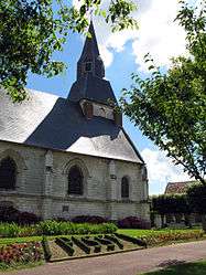
Places of interest
- The church
- The château,
- The mairie
- War memorial
- Two stone wells
See also
References
External links
| Wikimedia Commons has media related to Pissy. |
- Pissy on the Quid website (French)
This article is issued from Wikipedia - version of the 11/8/2016. The text is available under the Creative Commons Attribution/Share Alike but additional terms may apply for the media files.