Pinkenba, Queensland
| Pinkenba City of Brisbane, Queensland | |||||||||||||
|---|---|---|---|---|---|---|---|---|---|---|---|---|---|
 Bulwer Island, 2010 | |||||||||||||
 Pinkenba | |||||||||||||
| Coordinates | 27°26′S 153°7′E / 27.433°S 153.117°ECoordinates: 27°26′S 153°7′E / 27.433°S 153.117°E | ||||||||||||
| Population | 350 (2011 census)[1] | ||||||||||||
| Postcode(s) | 4008 | ||||||||||||
| Location | 9 km (6 mi) from Brisbane GPO | ||||||||||||
| LGA(s) | Brisbane City Council | ||||||||||||
| State electorate(s) | Electoral district of Clayfield | ||||||||||||
| Federal Division(s) | Lilley | ||||||||||||
| |||||||||||||
Pinkenba is the name of a suburb in eastern Brisbane, Australia, on the northern side of the Brisbane River, 10 kilometres (6.2 mi) from the Brisbane central business district. The area is spatially isolated from other residential suburbs and is surrounded by the Brisbane Airport to the north and west, and industrial land and the bank of the Brisbane River to the south. Pinkenba recorded a population of 350 people at the 2011 Australian Census.[1]
Numerous development projects have been proposed for the area, including residential developments and an immigration detention centre, but nothing has progressed. The suburb contains a small number of detached houses (primarily of weatherboard construction), local store, pub and industrial precincts.
The name Pinkenba comes from the Turrbal word binkinba which means "place of land tortoise".[2]
Demographics
In the 2011 census, Pinkenba recorded a population of 350 people; 42.9% female and 57.1% male. The median age of the Pinkenba population was 42 years, 5 years above the Australian median. Children aged under 15 years made up 15.4% of the population and people aged 65 years and over made up 12.8% of the population. 62.5% of people living in Pinkenba were born in Australia, compared to the national average of 69.8%; the next most common countries of birth were New Zealand 7%, Iran 6.8%, England 2.5%, Italy 1.4%, France 0.8%. 77.3% of people spoke only English at home; the next most popular languages were 2% Italian, 1.7% Cantonese, 1.1% Tagalog, 0.9% Afrikaans, 0.9% Serbo-Croatian/Yugoslavian. The most common religious affiliation was "No Religion" 22.8%; the next most common responses were Catholic 19.9%, Anglican 16.5%, Presbyterian and Reformed 5.4% and Uniting Church 4.3%.[1]
Transport
The suburb is accessed by road via Kingsford Smith Drive which passes an industrial area before reaching the suburb. Pinkenba is also the site of the now-abandoned Pinkenba railway station. The station opened in 1882 and closed in 1993. The branch line to Pinkenba was constructed so as to encourage port development downstream away from the Brisbane central business district.[3]
In Pinkenba, on the day of the 2011 census, 9.1% of employed people traveled to work on public transport and 63.6% by car (either as driver or as passenger).[1]
Industry
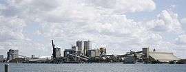
BP's Bulwer Island Refinery and Shell's Pinkenba Terminal are located in Pinkenba. In 2011, Shells operations at Bulwer Island were expanded with the opening of a new bitumen and marine fuel import facility.[4] Shell facilities include their Queensland state office, a bitumen plant, a lubricants and grease manufacturing facility, several warehouses and fuel storage unit.[5]
History

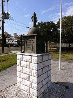
Pinkenba Wharf was the point of embarkation for many World War I soldiers. The Pinkenba & District War Memorial commemorates those from the district who served and died in the war. The memorial was unveiled on 16 August 1919 by the Queensland Governor, Sir Hamilton Goold-Adams.[6][7]
QANTAS selected Pinkenba for their flying boat base in the 1930s. Until the war, Hamilton Reach was too congested, however the base eventually moved upstream providing better access for passengers.[8]
On 6 March 1963, Queen Elizabeth II unveiled a roadside memorial which commemorates the discovery of commercial quantities of oil in Australia.[9] Although significant oil deposits had been found at Moonie the pipeline to Brisbane was not completed until the following year. The site was selected because it was close to a large oil refinery which was to process the oil.[9]
Trail
Pinkenba now has a historical trail which was designed on behalf of the Pinkenba Community Association and the Port of Brisbane with help from Brisbane City Council Neighbourhood planning team; more work is still to be done over the next ten years with the beautification of Pinkenba with the start being the local park and historical path and local pub.
Heritage listings
Pinkenba has a number of heritage-listed sites, including:
- Eagle Farm Road: Pinkenba War Memorial[10]
- Myrtletown Reserve: RAN Station 9, Pinkenba[11]
See also
References
- 1 2 3 4 Australian Bureau of Statistics (31 October 2012). "Pinkenba (State Suburb)". 2011 Census QuickStats. Retrieved 3 January 2013.
- ↑ "South-East Queensland Placenames" (PDF). State Library of Queensland.
- ↑ Laverty, John Robert (2009). The Making of a Metropolis: Brisbane 1823–1925. Boolarong Press. p. 73. ISBN 0975179357. Retrieved 3 January 2013.
- ↑ "Major addition to BP's Queensland infrastructure officially opened by the Hon Craig Wallace". Press Release. BP. 15 December 2011. Retrieved 3 January 2013.
- ↑ "Shell Pinkenba Terminal". Shell Australia. Retrieved 3 January 2013.
- ↑ "Pinkenba & District War Memorial". Monument Australia. Retrieved 5 April 2014.
- ↑ "PINKENBA SOLDIERS' MEMORIAL.". The Brisbane Courier. National Library of Australia. 18 August 1919. p. 7. Retrieved 6 April 2014.
- ↑ Jones, David (2007). Wings on the River. Boolarong Press. pp. 31, 42. ISBN 1921054271. Retrieved 3 January 2013.
- 1 2 Gregory, Helen; Dianne Mclay (2010). Building Brisbane's History: Structure, Sculptures, Stories and Secrets. Warriewood, New South Wales: Woodslane Press. p. 108. ISBN 9781921606199.
- ↑ "Pinkenba War Memorial (entry 602453)". Queensland Heritage Register. Queensland Heritage Council. Retrieved 6 July 2013.
- ↑ "RAN Station 9, Pinkenba (Myrtletown) (entry 602448)". Queensland Heritage Register. Queensland Heritage Council. Retrieved 6 July 2013.
External links
| Wikimedia Commons has media related to Pinkenba, Queensland. |
- University of Queensland: Queensland Places:Pinkenba
- "Pinkenba". BRISbites. Brisbane City Council. Archived from the original on 24 July 2008.
- "Pinkenba". Our Brisbane. Brisbane City Council. Archived from the original on 14 September 2007.