Pine Mountain Lake Airport
| Pine Mountain Lake Airport | |||||||||||
|---|---|---|---|---|---|---|---|---|---|---|---|
 | |||||||||||
| IATA: none – ICAO: none – FAA LID: E45 | |||||||||||
| Summary | |||||||||||
| Airport type | Tuolumne County | ||||||||||
| Operator | Groveland, California | ||||||||||
| Elevation AMSL | 2,930 ft / 893.1 m | ||||||||||
| Coordinates | 37°51′42″N 120°10′40″W / 37.86167°N 120.17778°W | ||||||||||
| Runways | |||||||||||
| |||||||||||
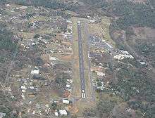
Pine Mountain Lake Airport (FAA LID: E45), formerly Q68, is a public airport located three miles (4.8 km) northeast of Groveland, serving Tuolumne County, California, USA. The airport is used mostly for general aviation. The airport is part of the Pine Mountain Lake community. The airport has public access.
Facilities
Pine Mountain Lake Airport covers 52 acres and has one runway:
- Runway 9/27: 3,625 x 50 ft (1,105 x 15 m), Surface: Asphalt
- Fuel - 24 Hour Self Service
- Parking tie-downs
- Air-frame Service
- Power-plant Service
Cautions to pilots: "Be alert deer on and in vicinity of airport especially Nov-Apr."
References
External links
- Resources for this airport:
- FAA airport information for E45
- AirNav airport information for E45
- FlightAware airport information and live flight tracker
- SkyVector aeronautical chart for E45
This article is issued from Wikipedia - version of the 1/4/2016. The text is available under the Creative Commons Attribution/Share Alike but additional terms may apply for the media files.