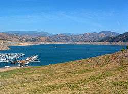
Pine Flat Lake
| Pine Flat Lake | |
|---|---|
 | |
| Location |
Sierra National Forest Sequoia National Forest Fresno County, California |
| Coordinates | 36°49′57″N 119°19′33″W / 36.8325°N 119.3259°WCoordinates: 36°49′57″N 119°19′33″W / 36.8325°N 119.3259°W |
| Type | Reservoir |
| Primary inflows | Kings River |
| Primary outflows | Kings River |
| Catchment area | 1,545 sq mi (4,000 km2) |
| Basin countries | United States |
| Max. length | 29.6 km (18.4 mi) |
| Surface area | 5,970 acres (2,420 ha) |
| Water volume | 1,000,000 acre·ft (1.2 km3) |
| Surface elevation | 261 m (856 ft) |
| References | U.S. Geological Survey Geographic Names Information System: Pine Flat Lake |
Pine Flat Lake is an artificial lake in the Sierra Nevada foothills of eastern Fresno County, California and provides the western north-south border to the Sierra- and Sequoia National Forests, about 30 mi (48 km) east of Fresno.
The lake was formed by the construction of Pine Flat Dam on the Kings River in 1954 by the United States Army Corps of Engineers, and has a storage capacity of 1,000,000 acre·ft (1.2 km3). Although primarily designed for flood control, the project also provides for irrigation and groundwater recharge, recreation, and with the completion in 1984 of the Jeff L. Taylor Pine Flat Power Plant, generation of 165 MW hydroelectric power.
Infrastructure security measures taken at the dam are greater than at most California dams, and the parapet wall cannot be approached from any direction. A large area in front of the dam that was previously accessible has been closed off, as have some roads and trails.
See also
- List of dams and reservoirs in California
- List of lakes in California
- List of largest reservoirs in the United States
- List of largest reservoirs of California
References
- Department of Water Resources (2009). "Station Meta Data: Pine Flat Dam (PNF)". California Data Exchange Center. State of California. Retrieved 2009-04-01.
- Construction Operations (2009). "Parks and Lakes: Pine Flat Lake". U.S. Army Corps of Engineers. Retrieved 2009-04-01.