Pinabacdao, Samar
| Pinabacdao | ||
|---|---|---|
| Municipality | ||
| Municipality of Pinabacdao | ||
| ||
| Nickname(s): "The Home of Mayaw-Mayaw Festival" | ||
| Motto: "Small Town, Big Dreams" | ||
 Map of Samar with Pinabacdao highlighted | ||
.svg.png) Pinabacdao Location within the Philippines | ||
| Coordinates: 11°37′N 124°59′E / 11.617°N 124.983°ECoordinates: 11°37′N 124°59′E / 11.617°N 124.983°E | ||
| Country | Philippines | |
| Region | Eastern Visayas (Region VIII) | |
| Province | Samar | |
| Congr. district | 2nd district of Samar | |
| Established | 1749 | |
| Reestablished | July 16, 1946 | |
| Barangays | 24 | |
| Government[1] | ||
| • Mayor | Engr. Teodorico Mabag[2] | |
| Area[3] | ||
| • Total | 183.06 km2 (70.68 sq mi) | |
| Population (1 August 2015)[4] | ||
| • Total | 18,252 | |
| • Density | 100/km2 (260/sq mi) | |
| Demonym(s) | Pinabakdawanon | |
| Time zone | PST (UTC+8) | |
| ZIP code | 6716 | |
| Dialing code | 55 | |


Pinabacdao, officially the Municipality of Pinabacdao (Waray: Bungtó han Pinabácdao; Cebuano: Lungsod sa Pinabacdao; Filipino: Bayan ng Pinabacdao) is a fourth class municipality [5] in the province of Samar, Philippines. According to the 2015 census, it has a population of 18,252.[4]
It lies at the south-west central coast of Samar Island and crossed along by the Pan-Philippine Highway. Pinabacdao is bordered to the north by the municipality of Calbiga; to the east by the capital city of Borongan in the province of Eastern Samar; to the west by the municipality of Villareal and Villareal Bay; and to the south by the municipalities of Santa Rita and Basey.
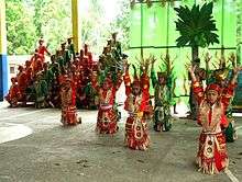
It is considered as the center of rice production in the province of Samar. The home of Mayaw-Mayaw Festival, an ethnic and dance festival celebrated every May 10 of each year.[6] Mayaw-Mayaw Festival won second runner-up in the festival dance competition and first prize winner in the float design competition during the 2015 Aliwan Fiesta which was held on April 23–25 in the cities of Manila and Pasay.[7]
Etymology
The term "Pinabácdao" or "Pinabakdaw" is a Waray Sinamar-Lineyte dialect that means "asked to stand" in English Language or simply "pinatayó" in Filipino Language. But in the book Atlas de Filipinas by José María Algué, SJ - a Spanish-Roman Catholic priest and meteorologist in the observatory of Manila published in 1899 (In 1900 published in English: Atlas of the Philippine Islands by the U.S. Coast and Geodetic Survey now U.S. National Geodetic Survey); Pinabacdao was cited as Pinabágdao and listed as a pueblo or town in the former island province of Samar.
Due to lack of official and authenticated historical accounts pertaining to the origin of the town's name, the municipal government is only relying on folktales which was handed from prominent ancestors to their eager descendants. Folktales revealed that the town of Pinabacdao got its present name by the time when the Philippines was still under the Spanish colonial era; the provincial governor of Samar asked Capitan Doquerez (believed to be the founder and first mayor of Pinabacdao) as to what punishment he would impose to those who violated any rule or law. Doquerez insisted that he will not impose fines and imprisonment, instead they will be punished by asking them to "bakdaw" or stand on an ant colony. The Spanish governor was then amused and concluded that since the punishment or "pena" in Spanish language is to "bakdaw" or stand the town deserves to be called "Pena-bakdaw" (respelled as Pinabacdao).
Another folktale or legend surrounding the town suggests that Pinabacdao's name was derived from miscommunication. These was the time when according to the folktale during the early years of settlement, officers from the Samar provincial government (probably on a mapping, census or exploratory survey) passed along the newly organized town and saw a man tied on a pole, standing on an ant colony. The Spanish officers asked one of the townsmen as to what is the name of the place. The townsman, not understanding the question in Spanish and thinking that the officer was pertaining to the tied man standing on ant colony immediately replied in Waray-waray dialect - "Pinabakdaw" or simply "asked to stand". This story was believed to be the reason why the bureaucrats recorded the name of the town as Pinabacdao.
In terms of official government record, the town is officially known as Pinabacdao by virtue of Executive Order No. 2 signed by president Manuel A. Roxas on July 8, 1946 and took effect on July 16, 1946.[8]
Political and Administrative Divisions
The municipality of Pinabacdao is politically divided into 24 barangays,[3] the smallest unit of local government in the Philippines. Each barangay has its own chairperson and councilors which forms the barangay council (Filipino: "Sanguniang Baranggay").
For administrative and statistical convenience, barangays are group into two districts - the upland barangays and pilot barangays. Upland district is composed of barangays situated in far-flung areas mostly those located in the eastern part of the municipality. Barangays located along Pan-Philippine Highway/National Road or commonly referred as Maharlika Highway (Filipino: "Daang Maharlika") comprises the Pilot district mostly those located in the western coastal and lowland areas. These districts have no form of any local government.
| Barangay[A] | District | Population | ±% p.a. | Classification | PSGC[9] | |||||||
|---|---|---|---|---|---|---|---|---|---|---|---|---|
| Bangon | Pilot | 7.8% | 1,425 | 1,243 | 2.64% | Rural | 086013001 | |||||
| Barangay 1, Poblacion | Pilot | 3.5% | 641 | 656 | −0.44% | Urban | 086013002 | |||||
| Barangay 2, Poblacion | Pilot | 4.9% | 895 | 766 | 3.01% | Rural | 086013003 | |||||
| Botoc | Pilot | 4.1% | 750 | 697 | 1.41% | Rural | 086013004 | |||||
| Bugho | Upland | 1.4% | 254 | 237 | 1.33% | Rural | 086013005 | |||||
| Calampong | Pilot | 3.1% | 572 | 512 | 2.13% | Rural | 086013006 | |||||
| Canlobo | Upland | 2.1% | 392 | 276 | 6.91% | Rural | 086013007 | |||||
| Catigawan | Upland | 0.7% | 135 | 134 | 0.14% | Rural | 086013008 | |||||
| Dolores (Kasang-an) | Pilot | 4.1% | 742 | 670 | 1.96% | Rural | 086013010 | |||||
| Lale | Pilot | 5.2% | 945 | 820 | 2.74% | Rural | 086013011 | |||||
| Lawaan | Upland | 1.8% | 327 | 305 | 1.33% | Rural | 086013012 | |||||
| Laygayon | Pilot | 5.4% | 994 | 816 | 2.64% | Rural | 086013013 | |||||
| Layo | Upland | 1.4% | 260 | 219 | 3.32% | Rural | 086013014 | |||||
| Loctob | Upland | 1.4% | 262 | 213 | 4.02% | Rural | 086013015 | |||||
| Madalunot (Antol) | Pilot | 5.0% | 914 | 730 | 4.37% | Rural | 086013016 | |||||
| Magdawat | Upland | 2.5% | 459 | 468 | −0.37% | Rural | 086013017 | |||||
| Mambog | Pilot | 7.7% | 1,412 | 1,368 | 0.60% | Rural | 086013018 | |||||
| Manaing | Upland | 1.7% | 312 | 233 | 5.72% | Rural | 086013019 | |||||
| Nabong | Pilot | 7.2% | 1,323 | 1,084 | 3.87% | Rural | 086013026 | |||||
| Obayan | Pilot | 6.8% | 1,234 | 1,105 | 2.12% | Rural | 086013020 | |||||
| Pahug | Pilot | 5.0% | 921 | 830 | 2.00% | Rural | 086013021 | |||||
| Parasanon | Pilot | 10.4% | 1,902 | 1,736 | 1.75% | Rural | 086013022 | |||||
| Pelaon | Upland | 4.5% | 829 | 754 | 1.82% | Rural | 086013023 | |||||
| San Isidro | Pilot | 1.9% | 352 | 336 | 0.89% | Rural | 086013025 | |||||
| Total | 18,252 | 16,208 | 2.29% | |||||||||
| ||||||||||||
History
Pinabacdao was established in 1749 but became a barrio in 1902 as part of the Municipality of Calbiga. It was then reestablished by Executive Order No. 02 series of 1946 issued by President Manuel A. Roxas, and separated from Calbiga as a reestablished municipality on July 16, 1946.
Demographics
| Population census of Pinabacdao | ||
|---|---|---|
| Year | Pop. | ±% p.a. |
| 1990 | 10,361 | — |
| 1995 | 11,590 | +2.12% |
| 2000 | 13,167 | +2.77% |
| 2007 | 14,492 | +1.33% |
| 2010 | 16,208 | +4.16% |
| 2015 | 18,252 | +2.29% |
| Source: Philippine Statistics Authority[4] | ||
Climate
Pinabacdao's climate is classified as tropical. Pinabacdao is a town with a significant rainfall. Even in the driest month there is a lot of rain. This location is classified as Af by Köppen and Geiger. The average annual temperature is 27.1 °C in Pinabacdao. The average annual rainfall is 2739 mm.[11]
Education
To carry out its mandates and objectives, the Philippine Department of Education is organized into two major structural components. The Central Office maintains the overall administration of basic education at the national level. The Field Offices are responsible for the regional and local coordination and administration of the Department’s mandate.[12]
At the sub-national level, the Field Offices are consist of regional offices and provincial/city schools division. Under the supervision of the provincial/city schools division offices are school districts.
School District of Pinabacdao
Before the creation of a separate school district for the municipality, schools were under the supervision of the District of Pinabacdao-San Sebastian. But due to an increasing number of schools in the municipality, Pinabacdao and San Sebastian municipalities had their own school district . The School District of Pinabacdao is tasked to manage and govern schools except the three secondary schools which are under the direct supervision of the Schools Division of Samar.
- Primary Schools
- Bugho Primary School (BPS)
- Canlobo Primary School (CanPS)
- Catigawan Primary School (CPS)
- Loctob Primary School (LPS)
- Magdawat Primary School (MPS)
- Elementary schools
- Bangon Elementary School (BES)
- Botoc Elementary School (BotES)
- Calampong Elementary School (CES)
- Dolores Elementary School (DES)
- Lale Elementary School (LES)
- Laygayon Elementary School (LayES)
- Madalunot Elementary School (MadES)
- Mambog Elementary School (MES)
- Nabong Elementary School (NES)
- Obayan Elementary School (OES)
- Pahug Elementary School (PES)
- Parasanon Elementary School (ParES)
- Pinabacdao Central Elementary School (PCES)
Secondary/High Schools
| Name of School | Abbreviation | Campus | Location |
|---|---|---|---|
| Parasanon National High School | ParNHS | Main | Barangay Parasanon |
| Pinabacdao National High School | PNHS | Main | Barangay 1, Poblacion |
| Quintin Quijano Sr. Agricultural School
(former West Coast Agricultural High School-WCAHS) |
QQSAS | Main | Barangay Mambog |
College and Training Center
- Pinabacdao One-Stop Training Center (POSTC)
- University of Eastern Philippines- Pinabacdao College of Agriculture (UEP-PCA)
See also
References
- ↑ "Municipalities". Quezon City, Philippines: Department of the Interior and Local Government. Retrieved 15 May 2013.
- ↑ "Election Results for Pinabacdao WSA". ivoteph. Retrieved 30 June 2016.
- 1 2 "Province: Samar (Western Samar)". PSGC Interactive. Makati City, Philippines: National Statistical Coordination Board. Retrieved 15 May 2013.
- 1 2 3 "Total Population by Province, City, Municipality and Barangay: as of August 1, 2015". 2015 Census of Population and Housing. Philippine Statistics Authory. Retrieved 30 June 2016.
- ↑ "Municipality Classification". NSCB. Retrieved 5 June 2015.
- ↑ "Eastern Visayas Festivals and Events". Visit My Philippines. Retrieved 29 June 2016.
- ↑ "Aliwan Fiesta 2015". Aliwan Fiesta. Retrieved 29 June 2016.
- ↑ "Executive Order No. 02, s.1946". Official Gazette of the Republic of the Philippines. Retrieved 5 June 2015.
- ↑ "PSGC Active Statistics". Philippine Statistics Authority. Retrieved 30 June 2016.
- ↑ "Region VIII (EASTERN VISAYAS)". Census of Population (2015): Total Population by Province, City, Municipality and Barangay (Report). PSA. Retrieved 20 June 2016.
- ↑ "Pinabacdao Climate". Climate-Data Org. Retrieved 5 June 2015.
- ↑ "DepEd Structural Components". DepEd Central Office. Retrieved 5 June 2016.
External links
| Wikimedia Commons has media related to Pinabacdao. |
- Philippine Standard Geographic Code
- Philippine Census Information
- Local Governance Performance Management System
 |
Zumarraga / Villareal Bay | Calbiga | | |
| Villareal | |
Borongan, Eastern Samar | ||
| ||||
| | ||||
| Santa Rita | Basey |
Catbalogan (capital) | |
| Municipalities | |
| Component cities | |