Pietermaritzburg
| Pietermaritzburg umGungundlovu (Zulu) | |
|---|---|
|
Downtown Pietermaritzburg as seen from Chase Valley | |
| Nickname(s): PMB, Maritzburg | |
 Pietermaritzburg  Pietermaritzburg  Pietermaritzburg
| |
| Coordinates: 29°37′S 30°23′E / 29.617°S 30.383°ECoordinates: 29°37′S 30°23′E / 29.617°S 30.383°E | |
| Country | South Africa |
| Province | KwaZulu-Natal |
| District | UMgungundlovu |
| Municipality | Msunduzi |
| Established | 1839[1] |
| Government | |
| • Type | Local Municipality |
| • Mayor | Themba Njilo[2] (2011) |
| Area[3] | |
| • Total | 126.15 km2 (48.71 sq mi) |
| Elevation | 596 m (1,955 ft) |
| Population (2011)[3] | |
| • Total | 223,448 |
| • Density | 1,800/km2 (4,600/sq mi) |
| Racial makeup (2011)[3] | |
| • Black African | 70.0% |
| • Coloured | 6.9% |
| • Indian/Asian | 8.4% |
| • White | 14.2% |
| • Other | 0.5% |
| First languages (2011)[3] | |
| • Zulu | 57.0% |
| • English | 28.9% |
| • Afrikaans | 4.2% |
| • Xhosa | 3.5% |
| • Other | 6.3% |
| Postal code (street) | 3201 |
| PO box | 3200 |
| Area code | 033 |

Pietermaritzburg (/ˌpiːtərˈmærᵻtsbɜːrɡ/;[4] Zulu: umGungundlovu) is the capital and second-largest city in the province of KwaZulu-Natal, South Africa. It was founded in 1838 and is currently governed by the Msunduzi Local Municipality. Its Zulu name umGungundlovu is the name used for the district municipality. Pietermaritzburg is popularly called Maritzburg in English and Zulu alike, and often informally abbreviated to PMB. It is a regionally important industrial hub, producing aluminium, timber and dairy products. It is home to many schools and tertiary education institutions, including a campus of the University of KwaZulu-Natal. It had a population of 228,549 in 1991;[5] the estimated current population is around 500,000 (including neighbouring townships) and has one of the largest populations of Indian South Africans in South Africa.
History
The city was originally founded by the Voortrekkers, following the defeat of Dingane at the Battle of Blood River, and was the capital of the short-lived Boer republic, Natalia. Britain took over Pietermaritzburg in 1843 and it became the seat of the Natal Colony's administration with the first lieutenant-governor, Martin West, making it his home. Fort Napier, named after the governor of the Cape Colony, Sir George Thomas Napier, was built to house a garrison. In 1893, Natal received responsibility for their own government and an assembly building was built along with the city hall. In 1910, when the Union of South Africa was formed, Natal became a province of the Union, and Pietermaritzburg remained the capital.
Name
There exist two interpretations about the origin of the city's name. One is that it was named after Piet Retief and Gert (Gerrit) Maritz, two Voortrekker leaders.[6] The other is that it was originally named after Piet Retief alone, since his full name was Pieter Maurits Retief. In this interpretation the original name was "Pieter Maurits Burg", later transliterated to the current name (Jenkins, 1971:11).

Retief in fact never reached Pietermaritzburg and was killed by Dingane, successor to Shaka, king of the Zulus. Maritz died of illness on 23 September 1838 near the present-day town of Estcourt, some hundreds of kilometres northwest of Pietermaritzburg. This was after the battle with the Zulus at Bloukranz, and Maritz did not ever reach the Pietermaritzburg area. In 1938, however, the city announced officially that the second element Maritz should also honour Gert Maritz.
At the time of the rise of the Zulu Empire, the site that was to become Pietermaritzburg was called Umgungundlovu. This is popularly translated from the Zulu as "Place of the Elephant", although it could also be translated to mean "The elephant wins". Umgungundlovu is thus thought to be the site of some Zulu king's victory since "Elephant" (Indlovu) is a name traditionally taken by the Zulu monarch. Legend has it that Shaka had his warriors hunt elephant there to sell the ivory to English traders at Durban (then called Port Natal). Today, the town is still called by its Voortrekker name, although the municipality of which it is part bears the Zulu name.
Apartheid
During apartheid, the city was segregated into various sections. 90% of the Indian population was moved to the suburb of Northdale while most of its Zulu inhabitants were moved to the neighbouring township of Edendale.
The University
The University of Natal was founded in 1910[7] as the Natal University College and extended to Durban in 1922. The two campuses were incorporated into the University of Natal in March 1949. It became a major voice in the struggle against apartheid and was one of the first universities in the country to provide education to black students. This campus boasts association with a remarkable array of world-class academics and has famous alumni distributed throughout the world. It became the University of KwaZulu-Natal on 1 January 2004.
Mahatma Gandhi
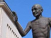
Pietermaritzburg was the site of an incident early in the life of Mahatma Gandhi. On 7 June 1893, while Gandhi was on his way to Pretoria, a white man objected to Gandhi's presence in a first-class carriage, and he was ordered to move to the van compartment at the end of the train. Gandhi, who had a first-class ticket, refused, and was thrown off the train at Pietermaritzburg. Shivering through the winter night in the waiting room of the station, Gandhi made the momentous decision to stay on in South Africa and fight the racial discrimination against Indians there. Out of that struggle emerged his unique version of nonviolent resistance, Satyagraha. Today, a bronze statue of Gandhi stands in Church Street, in the city centre.
Other historical events
- The first newspaper in Natal, the Natal Witness (now known as The Witness), was published in 1846.
- The 46 hectare Botanic Gardens were created in 1872 by the Botanic Society of Natal.
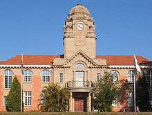
- The city hall, which is the largest red-brick building in the Southern Hemisphere, was destroyed by fire in 1895, but was rebuilt in 1901. It houses the largest pipe organ built by the Sheffield organ building company, Brindley & Foster.
- The British built a concentration camp here during the Second Boer War to house Boer women and children.
- During the Second World War, Italian prisoners of war were housed in Pietermaritzburg. During their stay, they built a church, which remains standing as a heritage site today.
- In 1962, Nelson Mandela was arrested in the nearby town of Howick to the north of Pietermaritzburg. The arrest marked the beginning of Nelson Mandela's 27 years of imprisonment. A small monument has been erected at the location of his arrest. Immediately after his arrest Mandela was taken to the Old Prison in Pietermaritzburg.[8] After a night in the prison, he was taken to Magistrate J. Buys’s office in the old Magistrates Court Building in Commercial Road (now Chief Albert Luthuli Road), and was remanded for trial in Johannesburg.[9]
Capital status
Prior to the end of white minority rule in 1994, Pietermaritzburg was the capital of Natal Province. Following the first post-apartheid elections in South Africa, as a result of which the Inkatha Freedom Party won a majority in the KwaZulu-Natal provincial government, Pietermaritzburg shared its status as capital of the (then newly created) province of KwaZulu-Natal with Ulundi. Pietermaritzburg became the legislative capital of the new province, while Ulundi became the administrative capital. The IFP, being strongly Zulu nationalist, desired that Ulundi, the capital of the Zulu Kingdom at the time of its fall to the British in the Anglo-Zulu War, be the post-apartheid capital of the province. Ulundi had also been the capital of the bantustan KwaZulu, which makes up a portion of modern KwaZulu-Natal. However, Ulundi severely lacked the infrastructure to be an effective seat of government, and the African National Congress (ANC) and the Democratic Party, the two other strong political parties in the province, among others, called for Pietermaritzburg alone to be the capital. The debate came to an end when the ANC came to power in the province in 2004, and named Pietermaritzburg the sole capital of KwaZulu-Natal. This has resulted in the relocation of several government offices to Pietermaritzburg. This has generally been welcomed as a positive development for the region. Since 2004, progress such as the modernisation of several buildings in the city centre and a proliferation of retail and housing developments in the suburbs are results of recent investment in the city by both the public and private sectors.
Coat of arms
The Pietermaritzburg borough council assumed a coat of arms in 1861.[10] The shield depicted an elephant standing on grass, and a cross of five stars was placed above the shield. The motto was Umgungunhlovu. It is unclear what the original colours were, but by 1910 the shield had been coloured blue.[11] By 1931, the council had approved new artwork in which the stars were placed on a radiant sun.[12] The arms were registered with the Natal Provincial Administration in November 1950.[13] Many early renditions of the coat of arms, visible on older public building and wrought iron lampposts, features an elephant which is clearly an Asian Elephant rather than an African elephant. More recent versions reflect an African elephant.
The final version of the arms was granted by the College of Arms in May 1961. It was registered at the Bureau of Heraldry in May 1973.[14] The blazon was : Per fess Azure and Vert, over all an elephant statant Or, tusked Argent (i.e. the shield was divided horizontally into blue over green, and displayed a gold elephant with silver tusks). The crest was changed to a blue sun displaying gold and silver stars, and two black wildebeest were added as supporters. Each had a shield on its shoulder, the dexter supporter's shield displaying the Union Jack and the sinister supporter's the flag of the Natalia republic.
Transport
Pietermaritzburg is on the N3 national road, the primary route between the Pretoria-Johannesburg-Witwatersrand conurbation and the harbour city of Durban, some 90 kilometres (56 mi) from Pietermaritzburg. The city is served by Pietermaritzburg (Oribi) Airport, which has regular scheduled service to OR Tambo International Airport in Johannesburg. Pietermaritzburg railway station is served by trains on the Johannesburg-Durban route of Shosholoza Meyl.
Geography and climate

| Pietermaritzburg | ||||||||||||||||||||||||||||||||||||||||||||||||||||||||||||
|---|---|---|---|---|---|---|---|---|---|---|---|---|---|---|---|---|---|---|---|---|---|---|---|---|---|---|---|---|---|---|---|---|---|---|---|---|---|---|---|---|---|---|---|---|---|---|---|---|---|---|---|---|---|---|---|---|---|---|---|---|
| Climate chart (explanation) | ||||||||||||||||||||||||||||||||||||||||||||||||||||||||||||
| ||||||||||||||||||||||||||||||||||||||||||||||||||||||||||||
| ||||||||||||||||||||||||||||||||||||||||||||||||||||||||||||
| Climate data for Pietermaritzburg | |||||||||||||
|---|---|---|---|---|---|---|---|---|---|---|---|---|---|
| Month | Jan | Feb | Mar | Apr | May | Jun | Jul | Aug | Sep | Oct | Nov | Dec | Year |
| Record high °C (°F) | 41 (106) |
39 (102) |
38 (100) |
37 (99) |
37 (99) |
31 (88) |
32 (90) |
35 (95) |
39 (102) |
40 (104) |
41 (106) |
42 (108) |
42 (108) |
| Average high °C (°F) | 28 (82) |
28 (82) |
28 (82) |
26 (79) |
24 (75) |
22 (72) |
23 (73) |
24 (75) |
25 (77) |
25 (77) |
26 (79) |
28 (82) |
26 (79) |
| Average low °C (°F) | 18 (64) |
17 (63) |
16 (61) |
12 (54) |
7 (45) |
3 (37) |
3 (37) |
6 (43) |
10 (50) |
13 (55) |
15 (59) |
16 (61) |
11 (52) |
| Record low °C (°F) | 9 (48) |
10 (50) |
5 (41) |
1 (34) |
−1 (30) |
−4 (25) |
−4 (25) |
−3 (27) |
−1 (30) |
2 (36) |
5 (41) |
6 (43) |
−4 (25) |
| Average precipitation mm (inches) | 155 (6.1) |
121 (4.76) |
113 (4.45) |
44 (1.73) |
30 (1.18) |
13 (0.51) |
2 (0.08) |
8 (0.31) |
64 (2.52) |
74 (2.91) |
100 (3.94) |
108 (4.25) |
832 (32.76) |
| Average precipitation days | 22 | 16 | 15 | 6 | 5 | 3 | 1 | 2 | 10 | 12 | 15 | 16 | 123 |
| Source: South African Weather Service[15] | |||||||||||||
Population
Key statistics (2011)
As of 2011,[16] the statistics for Pietermaritzburg are:
- Area: 126.15 square kilometres (48.71 sq mi)
- Population: 223 448: (106.99 inhabitants per square kilometre (277.1/sq mi))
- Households: 69 731 (28.55 per square kilometre (73.9/sq mi))
Sport
- South African cricketer David Miller was born in Pietermaritzburg on 10 June 1989.
- The English cricketer Kevin Pietersen was born in Pietermaritzburg on 27 June 1980, as was the Springbok cricketer Cuan McCarthy.
- The Comrades Marathon takes place annually in June between Pietermaritzburg and Durban. It has been run since 1921 and attracts thousands of entrants. The start of the race alternates between the two cities.
- The yearly Amashova is a 106 km (66 mi) road cycling classic race held since 1986 which starts in Pietermartizburg and finishes in Durban. It is normally held in October.
- In January there is an annual canoe race, Dusi Canoe Marathon, from Pietermaritzburg to Durban. The route follows the Msunduzi River into the Mgeni River, through the Valley of a Thousand Hills into the Inanda Dam and from here to the mouth of the Mgeni River.
- The Midmar Mile is one of the largest open-water swimming events in the world; taking place at Midmar Dam, north of Pietermaritzburg in February every year, it attracts over 16,000 swimmers from around the world.
- The most prominent soccer club is Maritzburg United, which plays in the Premier Soccer League.
- The Pietermaritzburg Oval is considered one of the most picturesque cricket grounds in South Africa, and it hosted two matches during the 2003 Cricket World Cup.
- Pietermaritzburg cricket ground is notable as one of the two grounds used regularly for first-class cricket that have a tree within the boundary (the other is St Lawrence Ground in Canterbury, Kent).
- Between December 1953 and November 1981, Pietermaritzburg had an international standard motor racing circuit located on the outskirts of the city. The Roy Hesketh Circuit measured 2.902 kilometres (1.803 mi). The circuit was named after South African driver Roy Hesketh.[17] During its period of operation it hosted rounds of the South African National Drivers Championship, the Springbok Series[18][19][20] and national Formula Atlantic races. The circuit was also like a second home to Mike Hailwood. The track was famous for hosting the Easter races as well – a festival of racing over three days. The expansion of the town of Pietermaritzburg eventually led to the redevelopment of the site as a residential and business zone after racing ceased at the end of 1981. The section from Henry's Knee to the top of Beacon still exists, and is undergoing protection from further development as an important piece of Pietermaritzburg's history. From 1948 until 1953 races were held at the 5.5-kilometre (3.4 mi) Alexandra Park Street Circuit on streets within the town of Pietermaritzburg.[21]
- In 2010, the Bmx Racing World Championship took place in the city of Pietermaritzburg between 15 July and 1 August.
Tourist Attractions, Entertainment and Surroundings
Some of the many Tourist Attractions include; The KwaZulu-Natal Museum, Tatham Art Gallery, City Hall and SANBI Botanical Gardens.
Some of the many Entertainments include; Capital Centre, The Mall @ Scottsville, Golden Horse Casino, Liberty Midlands Mall, Greater Edendale Mall and 033 Lifestyle.
Some of the many beautiful surrounding areas include; Albert Falls Nature Reserve, Howick Falls, Midmar Public Nature Reserve, Queens Elizabeth Park and World’s View.
Educational institutions
Pietermaritzburg is served by a number of schools and tertiary institutions. The University of KwaZulu-Natal is the largest educational institution in the city. Educational institutions
- Nsikayethu Secondary School
- Alexandra High School
- Bisley Park Primary School
- Carter High School
- Clifton Preparatory School
- Cordwalles Preparatory School
- Cowan House
- Deccan Road Primary School
- Edendale Technical High School
- Epworth School
- Eastwood Primary School
- Eastwood Secondary School
- Evangelical Seminary of Southern Africa
- Grace College
- Haythorne Secondary School-Woodlands,Pietermaritzburg
- Hilton College
- Heritage Academy
- Laddsworth Primary School
- Linpark High School
- Maritzburg College
- Maritzburg Christian School
- Russell High School
- Maritzburg Muslim School for Girls
- Merchiston Preparatory School
- Michaelhouse
- Northbury Park Secondary School
- Pietermaritzburg Girls' High School
- Raisethorpe Secondary School
- Scottsville School
- St. Anne's Diocesan College
- St. Charles College
- St. John's Diocesan School for Girls
- St Joseph's Theological Institute, Cedara
- Union Bible Institute
- University of KwaZulu-Natal
- Voortrekker High School
- The Wykeham Collegiate
- Haythorne Secondary School
- Woodlands Primary School
- Woodlands Secondary School
- Forest Hill Primary School
- Raisethorpe Secondary School
- Siyahlomula Secondary School
Civil society
Pietermaritzburg is home to a number of prominent civil society organisations including the Abahlali baseMjondolo (shackdwellers) movement, GroundWork, CINDI, PACSA, and the KwaZulu Natal Christian Council.[22][23][24][25][26]
Famous residents
- Don Armand, Rugby player (born 23 September 1988)
- Kork Ballington, World 250cc and 350cc Motorcycle Champion
- Melissa Carlton, Paralympic swimmer who represented Australia[27]
- Amod Cassimjee, One of the earliest known Indian settlers
- Brendon Dedekind, swimmer (born 14 February 1976)
- Jon Ekerold, World 350cc Motorcycle Champion
- Brett Evans, (born 8 March 1982) South African Football (soccer) player attended Merchiston Preparatory School and Maritzburg College and played for Maritzburg City as an amateur
- Adrian Furnham (born 1953), British-based organisational and applied psychologist and academic
- Tim Groenewald, Derbyshire and Warwickshire Cricketer (born 10 January 1984)
- Jonathan Handley, singer-songwriter (born 5 June 1954), originally from Springs, founder of The Radio Rats who in 1979 had a hit single "ZX Dan" on Radio 5 (now 5FM).
- Bessie Head, writer, was born in Pietermaritzburg in 1937.
- Roy Hesketh, (1915 - 19 September 1944) racing driver and South African Air Force pilot.
- Butch James, Springbok and Sharks rugby player attended Maritzburg College from 1994 to 2000. He played for Colleges' 3rd team.
- Stratford Johns, (22 September 1925 – 29 January 2002) popular British stage, film and television actor. Left for Britain in 1948.
- Peter Johnstone, Park Villa FC (born 1 September 1970 in Grey's Hospital,left PMB in 2004)
- Charlie Llewellyn, cricketer (born 29 September 1876), first non-White Test cricketer for South Africa.
- Clinton Marius, writer, performer (born 20 August 1966)
- Cuan McCarthy, fast-bowling The Proteas cricketer 1929–2000
- Phyllis McCarthy, noted authority and breeder of Rhodesian Ridgebacks
- Cathcart William Methven (1849–1925), painter, engineer and architect
- Greg Minnaar, three time Downhill World Cup champion (2001, 2005, 2008). He was also crowned Downhill World Champion in 2003. He attended Carter High School.
- Bryce Moon, (born 6 April 1986) South African Football (soccer) player was born in Pietermaritzburg and played for Pirates (PMB) in his youth
- Shaun Morgan, lead singer of Seether, is a former resident of Pietermaritzburg and attended both Merchiston Preparatory School and Maritzburg College while he lived there.
- Alan Paton, author of Cry the Beloved Country, was born in Pietermaritzburg.
- Kevin Pietersen, cricketer (born 27 June 1980).
- Jo-Anne Reyneke, Television actress (born 2 June 1988) She went to Alston Primary School and matriculated at Russell Girl's High School in 2005 with a Distinction in Drama.
- Jonty Rhodes, national cricketer (born 27 July 1969)
- Tom Sharpe, novelist, who described the city as "half the size of a New York cemetery and twice as dead".
- Peter Leslie Smith, Auxiliary Bishop for the Archdiocese of Portland in Oregon (born 1958)
- Guy Spier, Value Investor (born 4 February 1966 in Grey's hospital)
- Dale Stewart, bassist of Seether, is also a former resident of Pietemaritzburg.
- Kevin Volans, composer (born 6 July 1949)
Various
- Built in 1900, the City Hall was then the largest all-brick building in the southern hemisphere. It was declared a national monument in 1969.[28]
- At 14 metres high, the statue Pegasus adorning the entrance of the Golden Horse Casino was the largest statue of a horse in the world.[29][30] However, as of July 2010, the statue has been demolished due to internal structural damage.[31]
Twin towns – Sister cities
| City | Country | Year |
|---|---|---|
| Taichung | Taiwan | 1983 |
| Hampton | United States | 1998[32][33] |
See also
Bibliography
- Ingram, J Forsyth (1898). The story of an African city. Pietermaritzburg: C. Coester.
Notes
- ↑ "Chronological order of town establishment in South Africa based on Floyd (1960:20–26)" (PDF). pp. xlv–lii.
- ↑ "Msunduzi - Mayors Column". msunduzi.gov.za.
- 1 2 3 4 "Main Place Pietermaritzburg". Census 2011.
- ↑ Wells, John C. (2008), Longman Pronunciation Dictionary (3rd ed.), Longman, ISBN 9781405881180
- ↑ 1991 Census
- ↑ Rhoodie, E. M.; Keith S. O. Beavon (1976). "Pietermaritzburg". In William D. Halsey. Collier's Encyclopedia. 19. New York: Macmillan Educational Corporation. p. 43.
- ↑ "History of the University of KwaZulu-Natal".
- ↑ "The Old Prison". projectgateway.co.za.
- ↑ "Mandela and Pietermaritzburg - Maritzburg Sun". Maritzburg Sun.
- ↑ Anon.; 'Maritzburg's Municipal Insignia' in Archives News (Jan 1975).
- ↑ The arms were depicted on a colour poster issued by the Cape Times in 1910.
- ↑ The arms were depicted on a cigarette card issued in 1931.
- ↑ Natal Official Gazette 2317 (9 November 1950).
- ↑ http://www.national.archsrch.gov.za
- 1 2 "Climate data for Pietermaritzburg". South African Weather Service. Retrieved 7 March 2010.
- ↑ http://www.statssa.gov.za/publications/P0302/P03022011.pdf
- ↑ "Roy Hesketh the Racing Drivers Story". Roy Hesketh Circuit.
- ↑ Springbok Series – Sportscar championship in South Africa, that was run usually during winter. Until 1963 was Springbok series for F1 cars. Championship ended in 1973 after two races due to the Middle East oil crisis and never was restarted again... WSPR-racing.com
- ↑ South African Springbok Trophy Series – South African endurance sports car championship. It was usually held during the winter when the main season had been finished. Until 1963 the Springbok series was destined for F1 cars before it switched to mixed sports car and touring car field. The main race of the series was well known Kyalami 9 Hours, which enjoyed good international competition. Also many of the other races were well supported. Sports cars were limited to two litres in 1970 but three-litre cars were still allowed in the main 9-hour event, so even factory Ferrari took the challenge and won in Kyalami three consecutive times during 1970–72 period facing opposition of Porsche 917 and other great machinery of the time. The championship ended up in 1973 after only two races due to the Middle East oil crisis and was never restarted again. The Kyalami event was then shortened to 6 hours and became part of the World Manufacturers Championship, but only for a single season. It then continued under various rules sets and distances over the next decade appearing two more times in the World Sports Car Championship calendar (1983 and 1984) – but the latter was a complete fiasco and it never returned in its full 1,000 km (621 mi) distance, nor as part of the WSPC. Just a few shorter races were held for a few more years to come but 1985. WSRP.ic.cz
- ↑ "IMCA-slotracing.com". IMCA-slotracing.com. Retrieved 15 May 2011.
- ↑ "Alexandra Park Street Circuit". Guido de Carli.
- ↑ "World Habitat Day". Rajpatel.org. Retrieved 15 May 2011.
- ↑ "Cindi - Children In Distress Network". cindi.org.za.
- ↑ "GroundWork". GroundWork. Retrieved 15 May 2011.
- ↑ "KZNCC »". kzncc.org.za. horizontal tab character in
|title=at position 6 (help) - ↑ "South Africa: Post Abahlali baseMjondolo AGM speech by S'bu Zikode". Africafiles.org. 14 December 2008. Retrieved 15 May 2011.
- ↑ Carlton, Melissa. "Biography". Retrieved 16 January 2012.
- ↑ "Pietermaritzburg – Home Of Gandhi and The Comrades Marathon". Encounter South Africa. Retrieved 1 January 2007.
- ↑ "Pietermaritzburg Tourism". Archived from the original on 24 September 2006. Retrieved 1 January 2007.
- ↑ "Golden Horse Casino Hotel". CyberCapeTown Greater Durban Area Accommodation Portal. Retrieved 1 January 2007.
- ↑ http://www.witness.co.za/index.php?showcontent&global%5B_id%5D=43921
- ↑ "Sister Cities of Hampton, Virginia". Retrieved 7 November 2011.
- ↑ "Sister Cities International". Retrieved 7 November 2011.
References
- Jenkins, G. 1971. A Century of History: the story of Potchefstroom. 2nd ed. AA Balkema. Cape Town. 120 p.
External links
| Wikivoyage has a travel guide for Pietermaritzburg. |
| Wikimedia Commons has media related to Pietermaritzburg. |
Municipalities and communities of uMgungundlovu District Municipality, KwaZulu-Natal | ||
|---|---|---|
District seat: Pietermaritzburg | ||
| uMshwathi | .svg.png) | |
| uMngeni | ||
| Mpofana | ||
| Impendle | ||
| Msunduzi | ||
| Mkhambathini | ||
| Richmond | ||