Phalasarna
| Phalasarna Φαλάσαρνα | |
|---|---|
 Phalasarna | |
| Coordinates: 35°30′N 23°34′E / 35.500°N 23.567°ECoordinates: 35°30′N 23°34′E / 35.500°N 23.567°E | |
| Country | Greece |
| Administrative region | Crete |
| Regional unit | Chania |
| Municipality | Kissamos |
| Time zone | EET (UTC+2) |
| • Summer (DST) | EEST (UTC+3) |
| Postal code | 73400 |
| Area code(s) | 28210 |

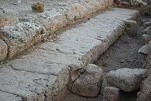

Falasarna or Phalasarna (Greek: Φαλάσαρνα) is an ancient Greek harbor town on the northwest coast of Crete. The currently visible remains of the city were built around 333 BC, and include several imposing sandstone towers and bastions, with hundreds of meters of fortification walls protecting the town, and a closed harbor, meaning it is protected on all sides by city walls. The harbor is ringed by stone quays with mooring stones, and connected to the sea through two artificial channels. Notable finds in the harbor area include public roads, wells, warehouses, an altar, and baths. Most of these structures were revealed by excavations that began in 1986.
The acropolis is built on a cape that rises 90 meters above the harbor and juts into the sea. The acropolis has many remains, including a temple dedicated to goddess Dictynna, fortification towers, cisterns, wells, and watchtowers that could have been used to guard sea routes.[1]
Today Phalasarna is an agricultural area and tourist attraction.
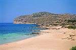
The valley is filled with olive groves and greenhouses cultivating mainly tomatoes; there are also scattered family-run hotels and restaurants. The seaside has long sandy beaches and crystal clear waters that are popular both with residents of the province of Chania and visitors from Greece and abroad. Falasarna beach was voted, in the CNN poll, among the best 100 beaches of the world.[2]
Ancient history
Phalasarna was mentioned by the ancient historians and geographers Scylax,[3] Strabo,[4] Polybius,[5] Livy,[6] Pliny,[7] Dionysius Kalliphontis,[8] and the anonymous geographer known as Stadiasmus.[9] The ancient geographers took note of the artificial closed port carved out of a lagoon and ringed with fortification walls and towers. Phalasarna was a maritime power; the harbor was the reason for the city's existence, the source of its wealth, and led to its recognition. A city-state with its own laws and minting its own coins, Phalasarna provided military advisers and thousands of mercenaries for a war under the Macedonian king Perseus against the Romans (Livy).
Phalasarna was involved in two major wars with neighboring city-states during the Hellenistic period. The first was with Polyrrhenia, probably triggered by land disputes. It started in the late fourth century and ended around 290 BC, following mediation by Cleonymus of Sparta. The peace treaty was inscribed on a stone tablet which is today in the museum of Kissamos.[10] A second war was fought with Cydonia around 184 BC and the disputes were finally resolved through Roman intervention (Polybius).
The city-state prospered with its maritime affairs, evidenced by the remains of monumental buildings and artwork. The treaty with Polyrrhenia gives evidence that in the third century BC the inhabitants of Phalasarna were engaged in piracy, a common practice of the Cretan city-states.[11] In 69-67 BC the Romans sent forces to eliminate piracy from the eastern Mediterranean, stormed Phalasarna, blocked its harbor with massive masonry, and destroyed the whole city, probably killing its citizens. No ancient sources testify directly to these events, but evidence of burning and the harbor blockage itself suggest the tentative conclusions of the excavators.[12][13]
The location of the city was then forgotten, and Phalasarna appears in Venetian records only as a lost city. The site was rediscovered in the 19th century by British explorers Robert Pashley and Captain T. A. B. Spratt. Spratt, of the Royal Navy, noted in 1859 that the former harbor of the deserted site was now 100 yards from the sea, and that the ancient sea coast must have risen at least twenty four feet. Modern excavation has confirmed this judgment, and also has shown that the harbor rapidly silted up after the Roman attack.[14] Radiocarbon dating of fossil algae along the ancient sea level mark on the cliffs around Phalasarna estimates the sudden sea level change at some time more than sixteen centuries ago. A probable event was the great earthquake and tsunami of 21 July A.D. 365, which wreaked catastrophic damage on all the coasts of the eastern Mediterranean and was recorded by Ammianus Marcellinus[15] and others. An ancient fish basin with two flights of steps carved into the coastal rocks near the harbor entrance has been cracked in half, probably during the same earthquake.[16]
Excavations

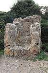
Rescue excavations at Phalasarna began in 1966 directed by the Ephor of the Department of Classical Antiquities in Chania, Dr. Yannis Tzedakis,[17] and continued under Vanna Niniou-Kindeli. Over 70 graves were uncovered, some of them pithos burials, and others cist graves. The early excavations were important, proving the site to have been inhabited in the 6th century BC. Since then, only a small part more of the cemetery has been excavated, and many beautiful artifacts have been recovered, among them a 4th-century pelike showing Eros chasing a Maenad. In the area of the necropolis there stands a two-meter high throne carved from stone, probably dedicated to the Phoenician goddess Astarte.[18]
Research excavations began in 1986 under Elpida Hadjidaki of the Greek Archaeological Service, and Frank Frost, of the University of California, Santa Barbara.[19][20] Major items excavated to date include two towers, a fortified gate, long sections of harbor quays with bollards in situ, a secondary basin, an industrial area, a public road, warehouses, an altar, and a water tank.
References
- ↑ http://phalasarna.org
- ↑ "World's 100 best beaches", CNN, 31 May 2013
- ↑ Scylax 47
- ↑ Strabo 10.13.5-10
- ↑ Polybius 22.15.2-6
- ↑ Livy, 42.51.7
- ↑ Pliny the Elder, Natural History, 4.59
- ↑ Dionysius Kalliphontis 118-122
- ↑ Stadiasmus Maris Magni 336
- ↑ Markoulaki S., "Stele from Tylifos" in the Proceedings of the 8th International Cretological Congress, Herakleion 1996 (Herakleion 2000) pp. 239-257, in Greek. English translation at attalus.org.
- ↑ de Souza, P., Piracy in the Graeco-Roman World (Cambridge, Cambridge University Press, 2000).
- ↑ Frost, F. "Tectonics and History at Phalasarna," Res Maritimae, American Schools of Oriental Research, Atlanta (1998) 107-115
- ↑ Hadjidaki, E. "The Roman Destruction of Phalasarna," Archaeology of the Roman Empire, edited by N. J. Higham, BAR International Series 940 (2001) 155-166.
- ↑ Pirazzoli, P. A., Ausseil-Badie, J. , Giresse, P., Hadjidaki, E. and Arnold, M. "Historical Environmental Changes at Phalasarna Harbor, West Crete," Geoarchaeology 7 (1992) 371-392.
- ↑ Ammianus Marcellinus, Res Gestae, 26.10.15- 19
- ↑ Papadopoulos, G., A Seismic History of Crete (Athens 2011) pp. 52-59
- ↑ Tzedakis, Y.,"Antiquities and Monuments of West Crete," Archaeologikon Deltion 24 (1969) pp. 433-434
- ↑ Di Vita A., I Fenici a Creta. Kommos, I "Troni di Astarte" a Phalasarna e la rota delle isole Di Annuario Della Scuola Archeologica Atene, 60-61, pp 175-203 (1992-93).
- ↑ Hadjidaki, E., "Preliminary Report of Excavations at the Harbor of Phalasarna in West Crete," American Journal of Archaeology, 92 (1988) 463-479
- ↑ Frost, F. and Hadjidaki, E., "Excavations at the Harbor of Phalasarna in Crete," Hesperia 59 (1990) 513-27