Petrich Peak
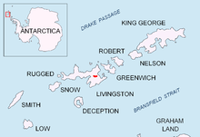
Location of Bowles Ridge on Livingston Island in the South Shetland Islands.
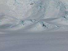
Petrich Peak from Zemen Knoll, with Tangra Mountains in the background.

Topographic map of Livingston Island, Greenwich, Robert, Snow and Smith Islands.
Petrich Peak (Vrah Petrich \'vr&h 'pet-rich\) is an ice-covered peak of elevation 760 m in central Bowles Ridge on Livingston Island in the South Shetland Islands, Antarctica, which is named after the town of Petrich in Southwestern Bulgaria.
Location
The peak is located at 62°36′56″S 60°10′39″W / 62.61556°S 60.17750°WCoordinates: 62°36′56″S 60°10′39″W / 62.61556°S 60.17750°Wm which is 400 m east of Ticha Peak, 1.98 km southwest of Melnik Peak, and 1.25 km west of the summit of Asparuh Peak (Bulgarian topographic survey Tangra 2004/05).
Maps
- L.L. Ivanov et al. Antarctica: Livingston Island and Greenwich Island, South Shetland Islands. Scale 1:100000 topographic map. Sofia: Antarctic Place-names Commission of Bulgaria, 2005.
- L.L. Ivanov. Antarctica: Livingston Island and Greenwich, Robert, Snow and Smith Islands. Scale 1:120000 topographic map. Troyan: Manfred Wörner Foundation, 2009. ISBN 978-954-92032-6-4
References
This article includes information from the Antarctic Place-names Commission of Bulgaria which is used with permission.
This article is issued from Wikipedia - version of the 11/21/2015. The text is available under the Creative Commons Attribution/Share Alike but additional terms may apply for the media files.