Petit-Lac-Sainte-Anne, Quebec
| Petit-Lac-Sainte-Anne | |
|---|---|
| Unorganized territory | |
 Location within Kamouraska RCM. | |
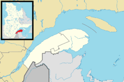 Petit-Lac-Sainte-Anne Location in eastern Quebec. | |
| Coordinates: 47°12′N 69°48′W / 47.200°N 69.800°WCoordinates: 47°12′N 69°48′W / 47.200°N 69.800°W[1] | |
| Country |
|
| Province |
|
| Region | Bas-Saint-Laurent |
| RCM | Kamouraska |
| Government[2] | |
| • Federal riding | Montmagny—L'Islet—Kamouraska—Rivière-du-Loup |
| • Prov. riding | Côte-du-Sud |
| Area[2][3] | |
| • Total | 188.60 km2 (72.82 sq mi) |
| • Land | 191.80 km2 (74.05 sq mi) |
|
There is an apparent contradiction between two authoritative sources | |
| Population (2011)[3] | |
| • Total | 0 |
| • Density | 0/km2 (0/sq mi) |
| • Pop 2006-2011 |
|
| • Dwellings | 1 |
| Time zone | EST (UTC−5) |
| • Summer (DST) | EDT (UTC−4) |
| Highways | No major routes |
Petit-Lac-Sainte-Anne is a unorganized territory in the Canadian province of Quebec, located in the Kamouraska Regional County Municipality.
See also
References
 |
Saint-Onésime-d'Ixworth | Mont-Carmel | | |
| |
||||
| ||||
| | ||||
| Tourville / Sainte-Perpétue | Saint-Omer | |
| Cities & Towns | |
|---|---|
| Municipalities | |
| Parishes | |
| Unorganized territories | |
| |
This article is issued from Wikipedia - version of the 10/8/2016. The text is available under the Creative Commons Attribution/Share Alike but additional terms may apply for the media files.