Petřín funicular
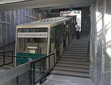


The Petřín funicular is a funicular railway in the Czech capital city of Prague. It links the Malá Strana district with the top of Petřín hill. The funicular has three stops: Újezd (at the bottom of the hill), Nebozízek (the middle station) and Petřín (at the top of the hill).
According to Czech legend, the name of the middle station Nebozízek stems from an incident in which little son of Emperor Charles IV, requesting food, was unable to properly pronounce the Czech letter "ř" when he requested for a schnitzel, so instead of "nebo řízek" (meaning, "or schnitzel"), he expressed the word Nebozízek which actually means diminutively one of types of auger.
History
The line was originally opened in 1891,[1] with a length of 383 metres (1,257 ft), a track gauge of 1,000 mm (3 ft 3 3⁄8 in) , and water balance propulsion. This original line closed with start of the First World War in 1914 and did not reopen after the end of hostilities.[1] The current longer line opened in 1932 with a different track gauge and completely new equipment, and operated throughout the Second World War. However a landslide in 1965 caused the service to be suspended, and it was not resumed until 1985.[1] At that time new cars were provided and the track was reconstructed, but the original machinery retained.[2]
Although design and architecture of the stations are similar to Prague Metro, the funicular is actually operated by the trams division of the city transport company.
Parameters
The funicular has the following technical parameters:[3]
- Length: 510 metres (1,673 ft)
- Height: 130 metres (427 ft)
- Stations: 3
- Cars: 2
- Maximum gradient: 29.5%
- Configuration: Single track with passing loop
- Track gauge: 1,435 mm (4 ft 8 1⁄2 in)
- Capacity: 101 passengers per car
- Traction: Electricity
See also
References
- 1 2 3 Wilson, Felice (6 December 2000). "Revamped funicular enjoys third life". The Prague Post. Retrieved 16 December 2013.
- ↑ "Public Funiculars of Czech Republic". funimag.com. Retrieved April 20, 2007.
- ↑ "Petrin". Funiculars.net. Retrieved April 20, 2007.
External links
| Wikimedia Commons has media related to Petřín Funicular. |
- Page on the Petřín funicular from DP Praha's official web site
- Article on the Petřín funicular from Funimag
Coordinates: 50°04′55″N 14°23′48″E / 50.08194°N 14.39667°E