Periglaciation

Periglaciation (adjective: "periglacial," also referring to places at the edges of glacial areas) describes geomorphic processes that result from seasonal thawing of snow in areas of permafrost, the runoff from which refreezes in ice wedges and other structures.[1][2] "Periglacial" suggests an environment located on the margin of past glaciers. However, freeze and thaw cycles influence landscapes outside areas of past glaciation. Therefore, periglacial environments are anywhere that freezing and thawing modify the landscape in a significant manner.[3]
Tundra is a common ecological community in periglacial areas.
History
Periglaciation became a distinct subject within the study of geology after Walery Łoziński, a Polish geologist, introduced the term in 1909.[4] Łoziński drew upon the early work of Johan Gunnar Andersson.[5] According to Alfred Jahn, his introduction of his work at the 1910 International Geological Congress held in Stockholm caused significant discussion. In the field trip to Svalbard that followed the congress participants were able to observe the phenomena reported by Łoziński, directly. Łoziński published his contribution to the congress in 1912.[6] From 1950 to 1970, periglacial geomorphology developed chiefly as a subdiscipline of climatic geomorphology that was current in Europe at the time.[5] The journal Biuletyn Peryglacjalny, established in 1954 by Jan Dylik, was important for the consolidation of the discipline.[7]
Periglacial zones and climates
Albeit the definition of what a periglacial zone is not clear-cut a conservativa estimated is that a quarter of Earth's land surface has periglacial conditions. Beyond this quarter an additional quarter or fifth or Earth's land surface had periglacial conditions at some time during the Pleistocene.[8] In the northern hemisphere larger swathes of northern Asia and northern North America are periglaciated. In Europe parts of Fennoscandia, Iceland, northern European Russia and Svalbard. In addition Alpine areas in the non-arctic northern hemisphere might also be subject to periglaciation. A major outlier in the northern hemisphere is the Tibetan Plateau that stands out by its size and low-latitude location.[8] In the southern hemisphere parts of the Andes, the ice-free areas of Antarctica and the sub-Antarctic islands are periglaciated.[8][9]
Since Carl Troll introduced the concept of periglacial climate in 1944 there have various attempts to classify the diversity of periglacial climates. Hugh M. French’s classification recognizes six climate types existing in the present:[10]
- High Arctic climates
- Continental climates
- Alpine climates
- Climate of the Qinghai-Xizang plateu
- Climates of low annual temperature range
- Climate of dry unglaciated areas of Antarctica
Factors affecting location
- Latitude – temperatures tend to be higher towards the equator. Periglacial environments tend to be found in higher latitudes. Since there is more land at these latitudes in the north, most of this effect is seen in the northern hemisphere. However, in lower latitudes, the direct effect of the sun's radiation is greater so the freeze-thaw effect is seen but permafrost is much less widespread.
- Altitude – Air temperature drops by approximately 1 °C for every 100 m rise above sea level. This means that on mountain ranges, modern periglacial conditions are found nearer the Equator than they are lower down.
- Ocean Currents – Cold surface currents from polar regions, reduce mean average temperatures in places where they exert their effect so that ice caps and periglacial conditions will show nearer to the Equator as in Labrador for example. Conversely, warm surface currents from tropical seas increases mean temperatures. The cold conditions are then found only in more northerly places. This is apparent in western North America which is affected by the North Pacific current. In the same way but more markedly, the Gulf Stream affects Western Europe.
- Continentality – Away from the moderating influence of the ocean, seasonal temperature variation is more extreme and freeze-thaw goes deeper. In the centres of Canada and Siberia, the permafrost typical of periglaciation goes deeper and extends further towards the Equator. Similarly, solifluction associated with freeze-thaw extends into somewhat lower latitudes than on western coasts.
Landforms of periglaciation

Periglaciation results in a variety of ground conditions but especially those involving irregular, mixed deposits created by ice wedges, solifluction, gelifluction, frost creep and rockfalls. Periglacial environments trend towards stable geomorphologies.[11]
- Coombe and head deposits – Coombe deposits are chalk deposits found below chalk escarpments in Southern England. Head deposits are more common below outcrops of granite on Dartmoor.
- Patterned Ground – Patterned ground occurs where stones form circles, polygons and stripes. Local topography affects which of these are expressed. A process called frost heaving is responsible for these features.
- Solifluction lobes – Solifluction lobes are formed when waterlogged soil slips down a slope due to gravity forming U shaped lobes.
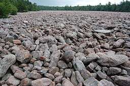
- Blockfields or Felsenmeer – Blockfields are areas covered by large angular blocks, traditionally believed to have been created by freeze-thaw action. A good example of a blockfield can be found in the Snowdonia National Park, Wales. Blockfields are common in the unglaciated parts of the Appalachian Mountains in the northeastern United States, such as at the River of Rocks or Hickory Run Boulder Field, Lehigh County, Pennsylvania.
Other landforms include:
River activity
Many areas of periglaciation have relatively low precipitation—otherwise, they would be glaciated—and low evapotranspiration. which makes their average river discharge rates low. However, rivers flowing into the Arctic Ocean adjacent to northern Canada and Siberia are prone to erosion resulting from earlier thawing of snow pack in the upper, more southerly reaches of their drainage basins, which leads to flooding downstream, owing to obstructing river ice in the still-frozen, downstream parts of the rivers. When these ice dams melt or break open, the release of impounded water causes erosion.
References
- ↑ Murck, Barbara (2001). Geology; A Self-teaching Guide. New York, New York: John Wiley & Sons, Inc. ISBN 0-471-38590-5.
- ↑ Slaymaker O., 2011. Criteria to distinguish between periglacial, proglacial and paraglacial environments. Quaestiones Geographicae 30(1): 85–94. DOI 10.2478/v10117-011-0008-y.
- ↑ Pidwirny, M (2006). "Periglacial Processes and Landforms". Fundamentals of Physical Geography.
- ↑ French, Hugh M. (June 1, 1980). "Periglacial geomorphology and permafrost". Progress in Physical Geography. Sage Journals. 4: 254–261. Retrieved 2016-09-26.
- 1 2 French 2007, pp. 3–4
- ↑ Mroczek, Przemysław (2010). "Stulecie pojêcia peryglacja" (PDF). Przegląd Geologiczny (in Polish). 58 (2): 130–132.
- ↑ French, Hugh M. (2008). "Periglacial Processes and Forms". In Burt, T.P.; Chorley, R.J.; Brunsden, D.; Cox, N.J.; Goudie, A.S. Quaternary and Recent Processes and Forms (1890–1965) and the Mid-Century Revolutions. The History of the Study of Landforms: Or the Development of Geomorphology. 4. pp. 647–49. ISBN 1862392498.
- 1 2 3 French 2007, pp. 11–13
- ↑ Boelhouwers, Jan; Holness, Steve; Sumner, Paul (2003). "The maritime Subantarctic: a distinct periglacial environment". Geomorphology. Elsevier. 52: 39–55.
- ↑ French 2007, pp. 32–34
- ↑ Brundsen, D (2001). A critical assessment of the sensitivity concept in geomorphology. Catena vol. 42.
- Bibliography
- French, Hugh M. (2007). The Periglacial Environment (3th ed.). John Wiley & Sons Ltd. ISBN 978-0-470-86588-0.
| Look up periglaciation in Wiktionary, the free dictionary. |