Pennsylvania Route 837
| ||||
|---|---|---|---|---|
 | ||||
| Route information | ||||
| Maintained by PennDOT | ||||
| Length: | 40.3 mi[1] (64.9 km) | |||
| Major junctions | ||||
| South end: |
| |||
|
| ||||
| North end: |
| |||
| Location | ||||
| Counties: | Washington, Allegheny | |||
| Highway system | ||||
| ||||

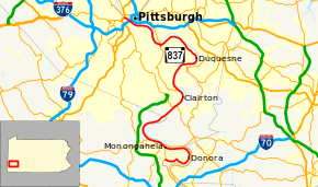
Pennsylvania Route 837 (PA 837) is a state route located in western Pennsylvania. The southern terminus of the route is at Pennsylvania Route 88 in the Carroll Township hamlet of Wickerham Manor. The northern terminus is at U.S. Route 19 and Pennsylvania Route 51 in downtown Pittsburgh at the junction of the Ohio, Allegheny and Monongahela rivers. The highway parallels the Monongahela River for all of its route with the exceptions of its extreme north and south ends. Popular amusement park Kennywood is located along this route.
Route description
Washington County
PA 837 begins at PA 88 in Carroll Township. It actually starts toward the east-southeast toward Donora. Before entering Donora, it turns to the north and passes the Monessen Bridge and becomes S. McKean Avenue. It leaves Donora as Meldon Avenue after passing the Donora-Webster Bridge at 10th Street.
After turning west, PA 837 enters Monongahela where it meets PA 88 again. It joins PA 88 for 2.5 miles (4.0 km) through Monongahela and New Eagle. After rounding another bend in the Monongahela River, PA 837 heads for West Elizabeth. Sixteen miles of PA 837 is in Washington County.[1]
Allegheny County
In West Elizabeth PA 837 is known as 5th Street (alternately, the Charles McDevitt Memorial Highway, after the former Mayor of that town) before it intersects PA 51 at the Elizabeth Bridge and turns back to the northwest toward Clairton. In Clairton, PA 837 is known as State St. and passes the Clairton Works, a large coke manufacturer. Paralleling the Monongahela River, winds through Dravosburg and Duquesne. Upon leaving Duquesne, Route 837 becomes Kennywood Blvd. as it passes Kennywood Park, a well-known amusement park in western Pennsylvania.
Shortly after passing Kennywood, PA 837 becomes 8th Avenue in Homestead. In Homestead, the highway passes The Waterfront, a large shopping center on the banks of the Monongahela. West of Homestead, PA 837 encounters a complex interchange with PA 885, Baldwin Rd., and Glass Run Rd.
PA 837 becomes E. Carson St. in the South Side Flats neighborhood of Pittsburgh. E. Carson St. is the main road of a major business district in the South Side. Carson St. then passes Station Square before travelling under the Fort Pitt Bridge and ending at the West End Circle.
PA 837 spends almost 25 miles (40 km) in Allegheny County. It is the south end of five bridges in Pittsburgh and passes under two others.[1]
Allegheny County Belt routes
Two of Allegheny County's colored belt routes align PA 837...
- Blue Belt (3.5 miles) from Becks Run Rd. in Baldwin to Homestead Grays Bridge in Homestead
- Green Belt (4 miles) from Rankin Bridge in Whitaker to McKeesport/Duquesne Bridge in Duquesne
A portion of the Orange Belt that was decommissioned in the 1970s also ran along PA 837 for 2.5 miles from the Regis Malady Bridge in Elizabeth to Finleyville-Elrama Rd. in Elrama
Major intersections
| County | Location | mi[1] | km | Destinations | Notes |
|---|---|---|---|---|---|
| Washington | Carroll Township | 0.0 | 0.0 | Southern terminus of PA 837 | |
| Donora | Interchange | ||||
| Monongahela | 8.5 | 13.7 | Southern terminus of PA 88 / PA 136 concurrency | ||
| 8.7 | 14.0 | Northern terminus of PA 481 | |||
| 9.7 | 15.6 | Northern terminus of PA 136 concurrency | |||
| New Eagle | 10.9 | 17.5 | Northern terminus of PA 88 concurrency | ||
| Allegheny | West Elizabeth | 17.8 | 28.6 | Interchange | |
| Clairton | 20.8 | 33.5 | Southern terminus of PA 885 | ||
| Duquesne | 26.4 | 42.5 | Interchange, southern terminus of Green Belt concurrency | ||
| Whitaker | 31.8 | 51.2 | Southwest end of bridge, northern terminus of Green Belt concurrency | ||
| Homestead | 32.1 | 51.7 | Southeast end of bridge, eastern terminus of Blue Belt concurrency | ||
| Pittsburgh | 33.6 | 54.1 | Interchange | ||
| 35.4 | 57.0 | Western terminus of Blue Belt concurrency | |||
| 36.6 | 58.9 | Hot Metal Street | |||
| 37.1 | 59.7 | Birmingham Bridge – Oakland | South end of Birmingham Bridge | ||
| 37.9 | 61.0 | S. Tenth Street – Downtown | South end of South Tenth Street Bridge | ||
| 38.8 | 62.4 | Smithfield Street Bridge – Downtown | South end of Smithfield Street Bridge | ||
| 39.8 | 64.1 | Exit 69C (I-376); access only from PA 837 south to I-376 east / I-376 west to PA 837 north | |||
| 40.3 | 64.9 | Northern terminus of PA 837, southern terminus of PA 60 | |||
1.000 mi = 1.609 km; 1.000 km = 0.621 mi
| |||||
PA 837 Truck
| |
|---|---|
| Location: | West Elizabeth, Pennsylvania |
| Existed: | 2007–present |
Pennsylvania Route 837 Truck is a truck route of PA 837 signed in 2007.
The route was established for trucks coming onto PA 837 from PA 51 south. It first utilizes the exit ramps from PA 837 to PA 51 south. It follows PA 51 south to an interchange at Ridge Road. It turns left on Ridge Road and makes a U-Turn back onto PA 51 north. It then utilizes the PA 51 exit ramps to PA 837.
See also
 U.S. Roads portal
 Pennsylvania portal
 Pittsburgh portal
References
- 1 2 3 4 Google (June 22, 2014). "Pennsylvania Route 837" (Map). Google Maps. Google. Retrieved June 22, 2014.
External links
| Wikimedia Commons has media related to Pennsylvania Route 837. |