Pennsylvania Route 41
| ||||
|---|---|---|---|---|
 | ||||
| Route information | ||||
| Maintained by PennDOT | ||||
| Length: | 22.220 mi[1] (35.760 km) | |||
| Major junctions | ||||
| South end: |
| |||
|
| ||||
| North end: |
| |||
| Location | ||||
| Counties: | Chester, Lancaster | |||
| Highway system | ||||
| ||||

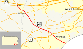
Pennsylvania Route 41 (PA 41) is a 22-mile-long (35 km) state highway located in southeastern Pennsylvania. The southern terminus of the route is at the Delaware state line in Kennett Township, where it continues as Delaware Route 41 (DE 41). The northern terminus is at U.S. Route 30 (US 30) in Gap. PA 41 runs along a two-lane undivided road called Gap Newport Pike, passing through mostly rural areas of Chester and Lancaster counties and serving Avondale, Cochranville, and Atglen. The route serves as the main road linking Wilmington, Delaware to Lancaster, Pennsylvania.
The Gap and Newport Turnpike was charted in 1807 to run from Gap southeast to the Delaware border, where it was to continue to Newport, Delaware. PA 41 was first designated in 1926 to run between US 22/PA 3/PA 13 in Harrisburg and US 22/PA 3 and US 120/PA 13 in Reading, following US 230 between Harrisburg and Lancaster and US 222 between Lancaster and Reading. PA 41 was rerouted at Lancaster to run southeast to the Delaware border in 1928, heading south from Lancaster to Lampeter along US 222/PA 72 before it turned east to Gap and southeast along the Gap Newport Pike. The western terminus was cut back to US 222 in Lampeter by 1930 while PA 741 was designated from PA 41 north to US 30 in Gap. PA 41 was rerouted to US 30 by 1940 while PA 741 was designated on the former alignment between US 222 in Lampeter and Gap.
Route description
PA 41 begins at the Delaware border in Kennett Township, Chester County, where the road continues into that state as DE 41 and heads towards Wilmington. From the state line, the route heads northwest on two-lane undivided Gap Newport Pike, passing through farmland with some development. The road enters New Garden Township and comes to an interchange with Limestone Road, which heads south to the Delaware border and becomes DE 7. PA 41 continues northwest through more rural areas with some homes and businesses. Then route heads into Avondale, where it crosses an East Penn Railroad line and comes to an intersection with Baltimore Pike. Here, the road becomes Pennsylvania Avenue and passes through wooded residential areas. PA 41 leaves Avondale for London Grove Township and becomes Gap Newport Pike again, passing near homes and farmland before Baltimore Pike heads to the west. The route continues through commercial areas before coming to an interchange with the US 1 freeway.[2][3]
Following this, the road runs through agricultural areas with some woods and homes, reaching an intersection with PA 841 in the community of Chatham. PA 41 continues through more rural areas and enters Londonderry Township, where it comes to a junction with PA 926. A short distance later, the road reaches a junction with the northern terminus of PA 796. The route runs through more farmland with some woodland and residences, crossing into West Fallowfield Township. Here, PA 41 comes to the community of Cochranville, where it crosses PA 10. After Cochranville, the road heads through more open farmland with some patches of woods and homes. The route briefly passes through a corner of West Sadsbury Township before it enters Atglen and comes to an intersection with PA 372. Following this, PA 41 heads into wooded areas and comes to a bridge over Amtrak's Philadelphia to Harrisburg Main Line. The road curves northwest and crosses back into West Sadsbury Township, passing through a mix of farm fields and development.[2][3]

PA 41 crosses Pine Creek into Sadsbury Township in Lancaster County and heads west past homes and businesses as it bypasses Christiana to the north. The road curves to the north-northwest and passes through a mix of farms and woods with some commercial development a short distance to the east of the Amtrak line. The route heads north and crosses into Salisbury Township, where it enters the residential community of Gap and comes to an intersection with the eastern terminus of PA 741. PA 41 heads into business areas and comes to its northern terminus at a junction with US 30 (Lincoln Highway), which provides access to Lancaster to the west.[2][4]
History
On April 7, 1807, the state of Pennsylvania chartered the Gap and Newport Turnpike to run from the Philadelphia and Lancaster Turnpike in Gap southeast towards Delaware, where it was to continue to the Christina River in Newport, Delaware. The continuation into Delaware was chartered on January 30, 1808.[5] The turnpike was created to improve trade between Lancaster County and Wilmington, Delaware.[6] When Pennsylvania first legislated routes in 1911, the Gap Newport Pike along with the road running from Gap west to Lancaster were designated as Legislative Route 215.[7] PA 41 was first designated in 1926 to run from US 22/PA 3/PA 13 in Harrisburg to US 22/PA 3 and US 120/PA 13 in Reading, heading southeast through Middletown, Elizabethtown, and Mount Joy to Lancaster, where it turned northeast and passed through Ephrata on its way to Reading. PA 41 ran concurrent with US 230 between Harrisburg and Lancaster and US 222 between Lancaster and Reading.[8][9]
In 1928, PA 41 was rerouted at Lancaster to head southeast to the Delaware border near Kaolin. The new alignment ran along US 222/PA 72 from Lancaster south and east to Lampeter, where PA 41 headed east through Strasburg to Gap. From Gap, PA 41 ran southeast along the Gap Newport Pike to the Delaware border. At this time, all of PA 41 was paved except for the portion between Strasburg and Gap. PA 240 replaced the PA 41 designation along the US 222 concurrency between Lancaster and Reading.[10] By 1930, the western terminus of PA 41 was cut back to US 222 near Lampeter, removing the concurrences with US 230 and US 222, while the road from PA 41 in Gap north to US 30 was designated as PA 741. By this time, the route was paved from a point east of Strasburg east to Gap.[11] The northern terminus of PA 41 was moved to its current location at US 30 by 1940, replacing PA 741. Meanwhile, PA 741 was designated onto the former alignment of PA 41 between US 222 near Lampeter and Gap.[12] In 1954, PA 41 was rerouted to bypass Atglen and Christiana to the northeast along its current alignment, having previously followed Fallowfield Road, Main Street, Zion Hill Road, and Newport Avenue.[13][14][15][16][17] By 1959, PA 41 was realigned to the east of Cochranville, having previously passed through the community on Cochran Street.[13][15]
Major intersections
| County | Location | mi[1] | km | Destinations | Notes |
|---|---|---|---|---|---|
| Chester | Kennett Township | 0.000 | 0.000 | Southern terminus, continuation into Delaware | |
| New Garden Township | 0.641 | 1.032 | Interchange | ||
| London Grove Township | 5.816 | 9.360 | Interchange, near Borough of Avondale | ||
| 7.206 | 11.597 | Village of Chatham | |||
| Londonderry Township | 9.822 | 15.807 | |||
| 10.413 | 16.758 | Northern terminus of PA 796 | |||
| West Fallowfield Township | 13.130 | 21.131 | Village of Cochranville | ||
| Atglen | 17.740 | 28.550 | |||
| Lancaster | Salisbury Township | 21.708 | 34.936 | Eastern terminus of PA 741 | |
| 22.220 | 35.760 | Northern terminus | |||
| 1.000 mi = 1.609 km; 1.000 km = 0.621 mi | |||||
See also
 U.S. Roads portal
 Pennsylvania portal
References
| Wikimedia Commons has media related to Pennsylvania Route 41. |
- 1 2 Bureau of Maintenance and Operations (January 2015). Roadway Management System Straight Line Diagrams (Report) (2015 ed.). Pennsylvania Department of Transportation. Retrieved June 30, 2015.
- Chester County (PDF)
- Lancaster County (PDF)
- 1 2 3 Google (November 26, 2012). "overview of Pennsylvania Route 41" (Map). Google Maps. Google. Retrieved November 26, 2012.
- 1 2 Chester County, Pennsylvania Highway Map (PDF) (Map). PennDOT. 2012. Retrieved November 26, 2012.
- ↑ Lancaster County, Pennsylvania Highway Map (PDF) (Map). PennDOT. 2012. Retrieved November 26, 2012.
- ↑ Scharf, John Thomas (1888). History of Delaware : 1609-1888, Volume 1. Philadelphia: L.J. Richards & Co. p. 416. Retrieved February 7, 2011.
- ↑ Ellis, Franklin and Samuel Evans (1883). History of Lancaster County, Pennsylvania with Biographical Sketches of its Pioneers and Prominent Men. Philadelphia: Everts & Peck. p. 313. Retrieved December 19, 2014.
- ↑ Map of Pennsylvania Showing State Highways (PDF) (Map). Pennsylvania Department of Highways. 1911. Retrieved January 1, 2014.
- ↑ Pennsylvania Highway Map (eastern side) (Map). Gulf Oil. 1926. Retrieved December 26, 2007.
- ↑ Pennsylvania Highway Map (Map). Pennsylvania Department of Highways. 1927. Retrieved December 26, 2007.
- ↑ Pennsylvania Highway Map (Philadelphia Metro) (Map). Gulf Oil. 1928. Retrieved November 8, 2007.
- ↑ Tourist Map of Pennsylvania (PDF) (Map). Pennsylvania Department of Highways. 1930. Retrieved January 1, 2014.
- ↑ Official Road Map of Pennsylvania (PDF) (Map). Pennsylvania Department of Highways. 1940. Retrieved June 24, 2010.
- 1 2 General Highway Map Chester County, Pennsylvania (PDF) (Map) (Sheet 1 ed.). Pennsylvania Department of Highways. 1941. Retrieved January 3, 2015.
- ↑ General Highway Map Lancaster County, Pennsylvania (PDF) (Map) (Sheet 1 ed.). Pennsylvania Department of Highways. 1941. Retrieved January 3, 2015.
- 1 2 General Highway Map Chester County, Pennsylvania (PDF) (Map) (Sheet 1 ed.). Pennsylvania Department of Highways. 1959. Retrieved December 16, 2014.
- ↑ General Highway Map Lancaster County, Pennsylvania (PDF) (Map) (Sheet 1 ed.). Pennsylvania Department of Highways. 1962. Retrieved January 3, 2015.
- ↑ Federal Highway Administration (2012). "NBI Structure Number: 000000000010022". National Bridge Inventory. Federal Highway Administration.