Penns Neck, New Jersey
| Penns Neck, New Jersey | |
|---|---|
| Unincorporated community | |
|
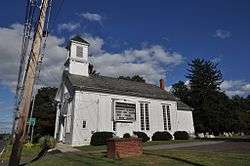
The historic Penns Neck Baptist Church. | |
 Penns Neck, New Jersey  Penns Neck, New Jersey  Penns Neck, New Jersey Penns Neck | |
| Coordinates: 40°19′56″N 74°38′13″W / 40.33222°N 74.63694°WCoordinates: 40°19′56″N 74°38′13″W / 40.33222°N 74.63694°W | |
| Country |
|
| State |
|
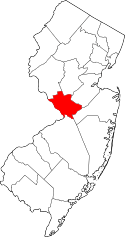
| County | Mercer |
| Township | West Windsor |
| Elevation[1] | 98 ft (30 m) |
| GNIS feature ID | 879214[1] |
- Not to be confused with Penn's Neck Township, a municipality in Salem County which no longer exists.
Penns Neck is an unincorporated community located within West Windsor Township in Mercer County, New Jersey, United States.[2] The community developed at the intersection of the Trenton-New Brunswick Turnpike and Washington Road.[3][4] The Penns Neck Circle and the historic Penns Neck Baptist Church are both located in Penns Neck. The Princeton Branch, known as the Dinky, runs through the area, and stopped at Penns Neck station until January 1971.[5]
References
- 1 2 "Penns Neck". Geographic Names Information System. United States Geological Survey.
- ↑ Locality Search, State of New Jersey. Accessed January 9, 2015.
- ↑ History, West Windsor Township, New Jersey. Accessed October 6, 2016. "Today, West Windsor can still identify the six farming villages that were a part of the area:... Penns Neck – on either side of Washington Road east of Route One"
- ↑ Google (January 25, 2015). "Penns Neck, New Jersey" (Map). Google Maps. Google. Retrieved January 25, 2015.
- ↑ Baer, Christopher T. "A General Chronology of the Pennsylvania Railroad Company, its Predecessors and Successors and its Historical Context: 1971", April 2015 edition. Accessed October 6, 2016. "Jan. 30, 1971 Last day of passenger service at Penns Neck station on Princeton Branch."
This article is issued from Wikipedia - version of the 10/6/2016. The text is available under the Creative Commons Attribution/Share Alike but additional terms may apply for the media files.