Penn State Erie (Behrend), Pennsylvania
| Penn State Erie (Behrend), Pennsylvania | |
|---|---|
| Census-designated place | |
_highlighted.svg.png) Location in Erie County and the state of Pennsylvania | |
| Coordinates: 42°07′06″N 79°58′54″W / 42.11833°N 79.98167°WCoordinates: 42°07′06″N 79°58′54″W / 42.11833°N 79.98167°W | |
| Country | United States |
| State | Pennsylvania |
| County | Erie |
| Township | Harborcreek |
| Area | |
| • Total | 0.8 sq mi (2.0 km2) |
| • Land | 0.8 sq mi (2.0 km2) |
| • Water | 0.0 sq mi (0.0 km2) |
| Elevation | 1,070 ft (330 m) |
| Population (2010) | |
| • Total | 1,629 |
| • Density | 2,078/sq mi (802.4/km2) |
| Time zone | Eastern (EST) (UTC-5) |
| • Summer (DST) | EDT (UTC-4) |
| FIPS code | 42-59212 |
| GNIS feature ID | 2633746 |
Penn State Erie (Behrend) is a census-designated place[1] located in Harborcreek Township, Erie County in the U.S. state of Pennsylvania. It is located around Penn State Erie near the city of Erie. As of the 2010 census the population was 1,629.[2]
References
- ↑ http://www.census.gov/2010census/
- ↑ "Geographic Identifiers: 2010 Census Summary File 1 (G001): Penn State Erie (Behrend) CDP, Pennsylvania". American Factfinder. U.S. Census Bureau. Retrieved March 22, 2016.
External links
Municipalities and communities of Erie County, Pennsylvania, United States | ||
|---|---|---|
| Cities | 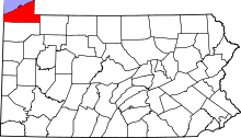 | |
| Boroughs | ||
| Townships | ||
| CDPs | ||
| Unincorporated communities | ||
This article is issued from Wikipedia - version of the 9/4/2016. The text is available under the Creative Commons Attribution/Share Alike but additional terms may apply for the media files.