Pegnitz (river)
| Pegnitz | |
|---|---|
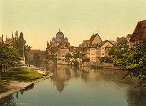
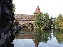 The Pegnitz in Nuremberg. | |
| Country | Germany |
| Basin | |
| Main source |
Franconia 425 m (1,394 ft) |
| River mouth |
Regnitz 49°29′11″N 10°59′12″E / 49.48639°N 10.98667°ECoordinates: 49°29′11″N 10°59′12″E / 49.48639°N 10.98667°E |
| Physical characteristics | |
| Length | 79 km (49 mi), with Fichtenohe 102 km (63 mi) |
The Pegnitz is a small river in Franconia in the German federal state of Bavaria. The Pegnitz has its source in the city of the same name at an altitude of 425 m (1,394 ft) and meets the Rednitz at 283 m (928 ft) in Fürth. From that point on the river is called Regnitz. But often esp. by local people the 23 km long Fichtenohe is regarded as upper course of the Pegnitz. The Fichtenohe source is in Lindenhardt Forest north of Pegnitz town.
The Pegnitz is about 79 km (49 mi) long, with Fichtenohe 102 km
The river is inhabited by numerous ducks, coots, swans, and gulls.
Tributaries
- Fichtenohe (stream)
- Flembach (stream) (left tributary)
- Hirschbach (stream) (left tributary)
- Högenbach (stream) (left tributary from the Pommelsbrunn direction)
- Happurger Bach (stream) (left tributary)
- Sittenbach (stream) (right tributary)
- Hammerbach (stream) (left tributary)
- Sandbach (stream) (left tributary)
- Schnaittach (stream) (right tributary)
- Röttenbach (stream) (right tributary)
- Bitterbach (stream) (right tributary)
- Röthenbach (stream) (left tributary)
- Langwassergraben (stream) (right tributary)
- Tiefgraben (stream) (right tributary)
- Goldbach (stream) (left tributary)
Cities on the Pegnitz

From source to mouth:
- Pegnitz
- Neuhaus on the Pegnitz
- Hersbruck
- Lauf an der Pegnitz
- Röthenbach an der Pegnitz
- Nuremberg: Within city limits (about 14 km), the river forms secondary arms. Numerous bridges and footbridges cross the river, such as the unchanged Renaissance bridge Fleischbrücke (1598) and the iron suspension bridge Kettensteg, dating from 1824. To the west of the Maxbrücke there is a weir. In the western part of the city, the river's ecological status was restored one section at a time from 1998 to 2001, using the historical river bed as an orientation.
- Fürth: Numerous bridges and footbridges exist. As part of project Uferstadt (riverside city), the redesign of the former Grundig site, the river bed was restored to being closer to nature in 2003. On a length of one kilometer, two new loops and shallowed banks have been created, and part of the former river bed have been kept in the form of backwaters. These activities were cofinanced by the European Union.
History
After the big flood in February 1909, straightening has shortened the river by four kilometers within the Nuremberg city limits.
Since 1996 planning and actions are progressing trying to lengthen the course of the river between Nuremberg and Fürth again and to shape it in a nature-oriented way.
External links
| Wikimedia Commons has media related to Pegnitz (River). |
- (German) http://www.bayern.de/wwa-n/stadtamfluss.htm - Wasserwirtschaftsamt Nürnberg: "Die Umgestaltung der Pegnitz in Nürnberg"