Peggys Cove, Nova Scotia
| Peggys Cove | |
|---|---|
| Community | |
|
Peggys Cove | |
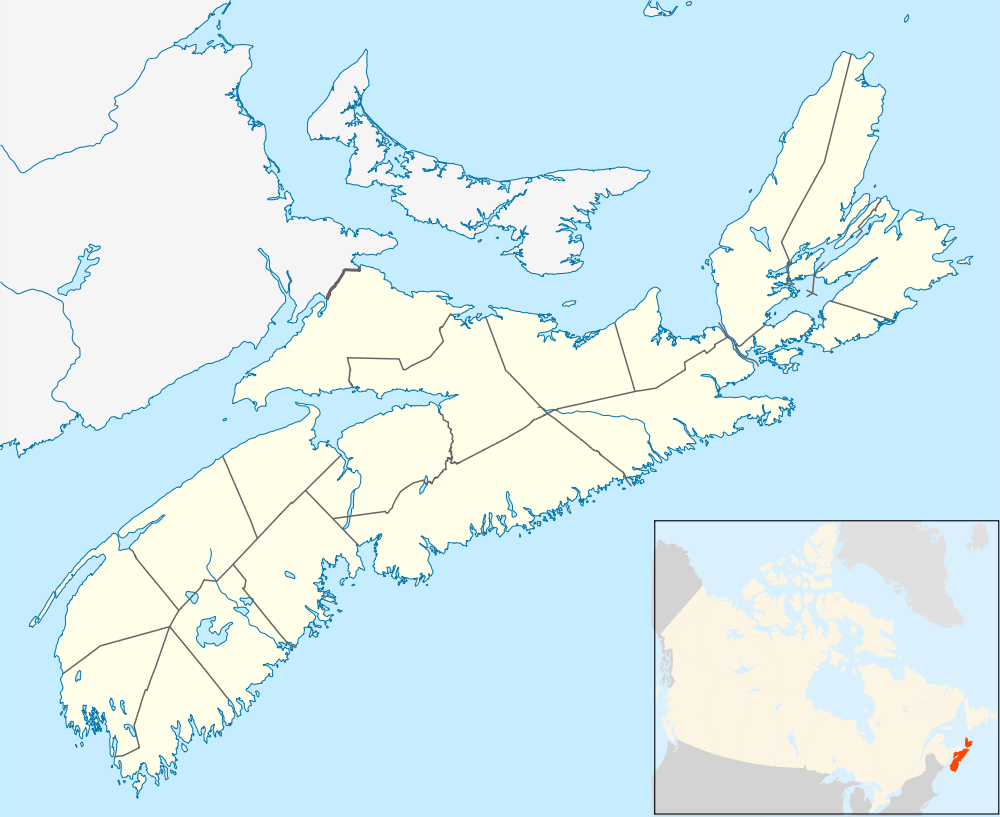 Peggys Cove Location of Peggys Cove in Nova Scotia | |
| Coordinates: 44°29′34″N 63°55′03″W / 44.49278°N 63.91750°W | |
| Country |
|
| Province |
|
| Region | Halifax |
| Administrative district | St. Margarets Bay |
| Founded | 1811 |
| Government | |
| • Governing body | Halifax Regional Community Council |
| Elevation | 10 m (30 ft) |
| Highest elevation | 15 m (49 ft) |
| Lowest elevation | 0 m (0 ft) |
| Population (2011) | |
| • Total | 640 |
| Time zone | ATS (UTC-4) |
| • Summer (DST) | Atlantic Daylight Saving Time (UTC-3) |
| Area code(s) | 902 & 782 |
| Highways |
|

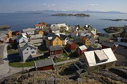
Peggys Cove is a small rural community located on the eastern shore of St. Margarets Bay in Nova Scotia's Halifax Regional Municipality, which is famous for the Peggys Point Lighthouse (established 1868).
Geography

Peggys Cove is 43 kilometers (26 miles) southwest of Downtown Halifax and comprises one of the numerous small fishing communities located around the perimeter of the Chebucto Peninsula. The community is named after the cove of the same name, a name also shared with Peggy's Point, immediately to the east of the cove. The village marks the eastern point of the St. Margaret's Bay.
History
The first recorded name of the cove was Eastern Point Harbour or Peggs Harbour in 1766. The village is likely named after Saint Margaret's Bay (Peggy being the nickname for Margaret), which Samuel de Champlain named after his mother Marguerite.[1] There has been much folklore created to explain the name. One story suggests the village may have been named after the wife of an early settler. The popular legend claims that the name came from the sole survivor of a shipwreck at Halibut Rock near the cove. Artist and resident William deGarthe said she was a young woman while others claim she was a little girl too young to remember her name and the family who adopted her called her Peggy.[2] The young shipwreck survivor married a resident of the cove in 1800 and became known as "Peggy of the Cove" attracting visitors from around the bay who eventually named the village, Peggy's Cove, after her nickname.[3]
The village was formally founded in 1811 when the Province of Nova Scotia issued a land grant of more than 800 acres (320 ha) to six families of German descent. The settlers relied on fishing as the mainstay of their economy but also farmed where the soil was fertile. They used surrounding lands to pasture cattle. In the early 1900s the population peaked at about 300. The community supported a schoolhouse, church, general store, lobster cannery and boats of all sizes that were nestled in the Cove.
Many artists and photographers flocked to Peggys Cove. As roads improved, the number of tourists increased. Today the population is smaller but Peggys Cove remains an active fishing village and a favourite tourist destination.
Roads and several homes were badly damaged at Peggys Cove in 2003 by the extensive flooding that accompanied Hurricane Juan which also damaged the cove's breakwater. The breakwater was further washed away by Hurricane Bill in 2009, allowing waves to seriously damage a home and giftshop, and washed away one of the cove's characteristic wooden fish sheds.
Tourism


From its inception, the community's economy revolved around the fishery. However, tourism began to overtake fishing in economic importance following the Second World War. Today, Peggys Cove is primarily a tourist attraction, although its inhabitants still fish for lobster, and the community maintains a rustic undeveloped appearance. The regional municipality and the provincial government have strict land-use regulations in the vicinity of Peggys Cove, with most property development being prohibited. Similarly there are restrictions on who can live in the community to prevent inflation of property values for year-round residents.
The historic Carpenter Gothic style St. John's Anglican Church, the only church in Peggys Cove, is a municipally designated heritage site.[4]
The first public art gallery, tea-room, and gift shop was opened in a shack in Peggys Cove in 1937.[5]
Geology

More than 400 million years ago, in the Devonian Period, the plate tectonics movement of the Earth's crust allowed molten material to bubble up from the Earth's interior. This formed the rocks we see today and are part of the Great Nova Scotia batholith. The unique landscape of Peggys Cove and surrounding areas was subsequently carved by the migration of glaciers and the ocean tides. About 20,000 years ago, an ice ridge moved south from Canada’s Arctic region covering much of North America. Along with the ebb and flow of the glaciers, the ice ridge eventually melted and shifted and in the process scooped away and scoured large sections of rock, vegetation, and topsoil. As melted land glaciers flowed back to the oceans the changing tidal flows and rising sea levels filled the scarred areas with water, forming coves and inlets. Large boulders composed of 415-million-year-old Devonian granite, called glacial erratics, were lifted by the ice and carried for long distances before being deposited upon the landscape as the ice receded, leaving rugged barrens. The movement of the glacial ice and rocks left scouring marks in the bedrock that are still visible.
Peggys Cove has been declared a preservation area to protect its rugged beauty. The Peggys Cove Commission Act, passed in 1962, prohibits development in and around the surrounding village and restricts development within Peggys Cove. The area comprised about 2,000 acres (8.1 km2) stretching from Indian Harbour to West Dover and includes barrens, bogs, inland ponds, and rocky coastline.

Atlantic Ocean
The Atlantic tide runs about 1.5–2 metres (4 ft 11 in–6 ft 7 in). The ocean temperature ranges between 12 and 20 degrees Celsius (54 to 68 degrees Fahrenheit) in the summer and falls to between 0.5 and 4.5 degrees Celsius (33 to 40 degrees Fahrenheit) in the winter. The ocean moderates the air temperature over the land year round.
The shape of the ocean floor and the numerous ocean currents facilitate a rich diversity of marine life along the Atlantic coastline. The Labrador Current flowing south from the Arctic cools the ocean during the summer months. Offshore, the Gulf Stream, travelling northwest from the Caribbean to the northern Europe warms the ocean waters. The confluence of currents off Nova Scotia brings unusual Arctic and tropical species to St. Margarets Bay. Marine life includes Atlantic bluefin tuna, white-sided and white-beaked dolphins, and pinnipeds. Endangered Atlantic leatherback sea turtles are seen in the waters near shore. Endangered right whales and many other species are found in the waters.
Cultural impact
The cove was the scene of a youth novel by Bryan Doyle called You Can Pick Me up at Peggy's Cove (1976) which later was made into a film directed by Don McBrearty and into a video released by Beacon Films, Inc., in 1982.
In 2016 it was announced that a Peggy's Cove-themed resort had opened in Thailand.[6]
William deGarthe
Sculptor and painter William E. deGarthe lived in Peggys Cove. A gallery exhibiting his work is open to the public between May 1 and October 31 each year. Outside the gallery, in the William E. deGarthe Provincial Park, is a carved granite outcropping. This 30 m (100 ft) sculpture was carved by deGarthe as "a lasting monument to Nova Scotian fishermen." It depicts 32 fishermen, their wives, and children enveloped by the wings of St. Elmo, the patron saint of sailors, as well as the legendary Peggy.

Swissair Flight 111
On September 2, 1998, Swissair Flight 111 crashed into St. Margaret’s Bay with the loss of all aboard. One of two memorials to the victims of the disaster is located at The Whalesback, a promontory approximately 1 km northwest of Peggy’s Cove. The other is located at Bayswater, Nova Scotia, on the Aspotogan Peninsula on the western shore of the bay. The two monuments and the actual crash site are at the vertices of a roughly equilateral triangle across the bay.
The monument at Whalesback reads in English and French: "In memory of the 229 men, women and children aboard Swissair Flight 111 who perished off these shores September 2nd, 1998. They have been joined to the sea, and the sky. May they rest in peace." The three notches represent the numerals 111. The sight line from the three grooves in the stone points to the crash site, while the markings on the facing stone point to the memorial at Bayswater. The memorial wall at Bayswater contains the names of the 229 passengers and crew of flight 111. The facing stone points to the crash site.

References
- ↑ Peggy's Cove: The Amazing History of a Coastal Village by Lesley Choyce. Over 150 years later DesBarres used his mothers name to rename the bay, Saint Charlotte's Bay.
- ↑ 'William deGarthe, This is Peggy's Cove
- ↑ Bruce Nunn, History with a Twist, Nimbus Publishing Ltd., pp. 49-53
- ↑ Canada's Historic Places: St. John's Anglican Church
- ↑ Peggy's Cove Mist and Rocks, by R. Webber,2013 ISBN 1897462301
- ↑ Lisa Blackburn, "Iconic Peggys Cove recreated at resort in Thailand", CBC News, July 07, 2016
Sources
- List of Lights 1870-1998 Canadian Coast Guard
- Peggys Cove Geological Guide Nova Scotia Department of Natural Resources
- HRM Civic Address Map
External links
| Wikimedia Commons has media related to Peggys Cove. |
| Wikimedia Commons has media related to Peggys Cove, Nova Scotia. |
-
 Peggys Cove travel guide from Wikivoyage
 - Peggys Cove Lighthouse page - Nova Scotia Lighthouse Preservation Society
- HalifaxTrails.ca
Coordinates: 44°29′34″N 63°55′03″W / 44.49278°N 63.91750°W
| Counties | |
|---|---|
| Economic Regions | |
| Regional municipalities | |
| Municipal districts | |
| Towns | |
| Incorporated villages | |
| Lists | |
| |