Pechora
| Pechora (English) Печора (Russian) Печӧра (Komi) | |
|---|---|
| - Town[1] - | |
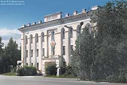 Drama theater building in Pechora | |
.svg.png) Location of the Komi Republic in Russia | |
 Pechora | |
|
| |
_(1983).png) | |
|
| |
| Administrative status (as of December 2014) | |
| Country | Russia |
| Federal subject | Komi Republic[1] |
| Administratively subordinated to | town of republic significance of Pechora[1] |
| Administrative center of | town of republic significance of Pechora[1] |
| Municipal status (as of December 2014) | |
| Municipal district | Pechora Municipal District[2] |
| Urban settlement | Pechora Urban Settlement[2] |
| Administrative center of | Pechora Municipal District,[2] Pechora Urban Settlement[2] |
| Head | Vladimir Mennikov |
| Statistics | |
| Population (2010 Census) | 43,105 inhabitants[3] |
| Time zone | MSK (UTC+03:00)[4] |
| Town status since | 1949 |
| Postal code(s)[5] | 169600, 169601, 169606, 169607, 169609, 169615, 169616, 169619, 169669 |
| Dialing code(s) | +7 82142 |
|
| |
| Pechora on Wikimedia Commons | |
Pechora (Russian: Печо́ра; Komi: Печӧра, Pečöra) is a town in the Komi Republic, Russia, located on the Pechora River, west of and near the northern Ural Mountains. Population: 43,105 (2010 Census);[3] 48,700 (2002 Census);[6] 64,746 (1989 Census).[7]
History
Pechora was granted town status in 1949. Pechora was also the site of a Stalin-era gulag that operated from 1932 to 1953, although was partially emptied in 1941 as many of the in-mates were forced into service in the Red Army. There is a dedicated room at the Pechora museum where they display many of the records and artefacts that were recovered from the gulag.[8]
Administrative and municipal status
Within the framework of administrative divisions, the town of Pechora is, together with two urban-type settlement administrative territories (comprising the urban-type settlements of Kozhva and Puteyets and eleven rural localities) and four rural-type settlement administrative territories (comprising seventeen rural localities), incorporated as the town of republic significance of Pechora—an administrative unit with the status equal to that of the districts.[1] As a municipal division, the town of republic significance of Pechora is incorporated as Pechora Municipal District; the town of Pechora is incorporated within it as Pechora Urban Settlement.[2] The two urban-type settlement administrative territories are incorporated into two urban settlements, and the four rural-type settlement administrative territories are incorporated into four rural settlements within the municipal district.[2]
Transportation
The town is served by the Pechora Airport and the Pechora Railway.
Military
Pechora Kamenka military air base and Pechora Radar Station are located nearby.
Climate
Pechora has a subarctic climate (Köppen climate classification Dfc). Winters are very cold, with average low temperatures in January of −22.5 °C (−8.5 °F) in January. Summers are mild, with average high temperatures in July of +21.7 °C (71.1 °F). Precipitation is moderate and is somewhat higher in summer than at other times of the year.
| Climate data for Pechora | |||||||||||||
|---|---|---|---|---|---|---|---|---|---|---|---|---|---|
| Month | Jan | Feb | Mar | Apr | May | Jun | Jul | Aug | Sep | Oct | Nov | Dec | Year |
| Record high °C (°F) | 2.5 (36.5) |
2.5 (36.5) |
11.0 (51.8) |
21.9 (71.4) |
30.6 (87.1) |
34.1 (93.4) |
34.9 (94.8) |
32.4 (90.3) |
27.6 (81.7) |
20.0 (68) |
7.7 (45.9) |
3.5 (38.3) |
34.9 (94.8) |
| Average high °C (°F) | −14.4 (6.1) |
−13.0 (8.6) |
−3.6 (25.5) |
2.5 (36.5) |
9.5 (49.1) |
18.0 (64.4) |
21.7 (71.1) |
16.9 (62.4) |
10.3 (50.5) |
2.2 (36) |
−7.3 (18.9) |
−11.9 (10.6) |
2.58 (36.64) |
| Daily mean °C (°F) | −18.4 (−1.1) |
−17.2 (1) |
−8.9 (16) |
−3.2 (26.2) |
4.2 (39.6) |
12.3 (54.1) |
16.1 (61) |
12.0 (53.6) |
6.5 (43.7) |
−0.2 (31.6) |
−10.5 (13.1) |
−15.7 (3.7) |
−1.92 (28.54) |
| Average low °C (°F) | −22.5 (−8.5) |
−21.4 (−6.5) |
−13.7 (7.3) |
−8.3 (17.1) |
−0.3 (31.5) |
7.4 (45.3) |
11.1 (52) |
8.0 (46.4) |
3.6 (38.5) |
−2.6 (27.3) |
−13.8 (7.2) |
−19.8 (−3.6) |
−6.02 (21.17) |
| Record low °C (°F) | −54.7 (−66.5) |
−56.0 (−68.8) |
−44.7 (−48.5) |
−35.7 (−32.3) |
−23.3 (−9.9) |
−5.6 (21.9) |
0.1 (32.2) |
−3.1 (26.4) |
−9.5 (14.9) |
−33.9 (−29) |
−43.3 (−45.9) |
−52.5 (−62.5) |
−56 (−68.8) |
| Average precipitation mm (inches) | 42 (1.65) |
33 (1.3) |
32 (1.26) |
33 (1.3) |
45 (1.77) |
67 (2.64) |
72 (2.83) |
77 (3.03) |
62 (2.44) |
63 (2.48) |
49 (1.93) |
50 (1.97) |
625 (24.6) |
| Average rainy days | 2 | 1 | 3 | 9 | 16 | 20 | 19 | 23 | 23 | 17 | 6 | 4 | 143 |
| Average snowy days | 25 | 21 | 21 | 12 | 6 | 1 | 0 | 0 | 1 | 11 | 20 | 24 | 142 |
| Mean monthly sunshine hours | 9.3 | 56 | 124 | 195 | 207 | 294 | 303.8 | 189.1 | 96 | 49.6 | 15 | 3.1 | 1,541.9 |
| Source #1: pogoda.ru.net[9] | |||||||||||||
| Source #2: http://en.allmetsat.com/climate/russia.php?code=23418 | |||||||||||||


References
Notes
- 1 2 3 4 5 Law #16-RZ
- 1 2 3 4 5 6 Law #11-RZ
- 1 2 Russian Federal State Statistics Service (2011). "Всероссийская перепись населения 2010 года. Том 1" [2010 All-Russian Population Census, vol. 1]. Всероссийская перепись населения 2010 года (2010 All-Russia Population Census) (in Russian). Federal State Statistics Service. Retrieved June 29, 2012.
- ↑ Правительство Российской Федерации. Федеральный закон №107-ФЗ от 3 июня 2011 г. «Об исчислении времени», в ред. Федерального закона №271-ФЗ от 03 июля 2016 г. «О внесении изменений в Федеральный закон "Об исчислении времени"». Вступил в силу по истечении шестидесяти дней после дня официального опубликования (6 августа 2011 г.). Опубликован: "Российская газета", №120, 6 июня 2011 г. (Government of the Russian Federation. Federal Law #107-FZ of June 31, 2011 On Calculating Time, as amended by the Federal Law #271-FZ of July 03, 2016 On Amending Federal Law "On Calculating Time". Effective as of after sixty days following the day of the official publication.).
- ↑ Почта России. Информационно-вычислительный центр ОАСУ РПО. (Russian Post). Поиск объектов почтовой связи (Postal Objects Search) (Russian)
- ↑ Russian Federal State Statistics Service (May 21, 2004). "Численность населения России, субъектов Российской Федерации в составе федеральных округов, районов, городских поселений, сельских населённых пунктов – районных центров и сельских населённых пунктов с населением 3 тысячи и более человек" [Population of Russia, Its Federal Districts, Federal Subjects, Districts, Urban Localities, Rural Localities—Administrative Centers, and Rural Localities with Population of Over 3,000] (XLS). Всероссийская перепись населения 2002 года [All-Russia Population Census of 2002] (in Russian). Retrieved August 9, 2014.
- ↑ Demoscope Weekly (1989). "Всесоюзная перепись населения 1989 г. Численность наличного населения союзных и автономных республик, автономных областей и округов, краёв, областей, районов, городских поселений и сёл-райцентров" [All Union Population Census of 1989: Present Population of Union and Autonomous Republics, Autonomous Oblasts and Okrugs, Krais, Oblasts, Districts, Urban Settlements, and Villages Serving as District Administrative Centers]. Всесоюзная перепись населения 1989 года [All-Union Population Census of 1989] (in Russian). Институт демографии Национального исследовательского университета: Высшая школа экономики [Institute of Demography at the National Research University: Higher School of Economics]. Retrieved August 9, 2014.
- ↑ http://www.bbc.co.uk/history/ww2peopleswar/stories/20/a3271420.shtml
- ↑ —Погода и Климат. Retrieved December 17, 2012.
Sources
- Государственный Совет Республики Коми. Закон №13-РЗ от 6 марта 2006 г. «Об административно-территориальном устройстве Республики Коми», в ред. Закона №171-РЗ от 26 декабря 2014 г. «Об упразднении населённого пункта Верхняя Седка, расположенного на территории Прилузского района Республики Коми, и внесении в связи с этим изменений в некоторые Законы Республики Коми». Вступил в силу со дня официального опубликования. Опубликован: "Республика", №44, 16 марта 2006 г. (State Council of the Komi Republic. Law #16-RZ of March 6, 2006 On the Administrative-Territorial Structure of the Komi Republic, as amended by the Law #171-RZ of December 26, 2014 On Abolishing the Inhabited Locality of Verkhnyaya Sedka Located on the Territory of Priluzsky District of the Komi Republic, and on Amending Various Laws of the Komi Republic Accordingly. Effective as of the official publication date.).
- Государственный Совет Республики Коми. Закон №11-РЗ от 5 марта 2005 г. «О территориальной организации местного самоуправления в Республике Коми», в ред. Закона №171-РЗ от 26 декабря 2014 г. «Об упразднении населённого пункта Верхняя Седка, расположенного на территории Прилузского района Республики Коми, и внесении в связи с этим изменений в некоторые Законы Республики Коми». Вступил в силу 1 апреля 2005 г.. Опубликован: "Республика", №44–45, 17 марта 2005 г. (State Council of the Komi Republic. Law #11-RZ of March 5, 2005 On the Territorial Organization of the Local Self-Government in the Komi Republic, as amended by the Law #171-RZ of December 26, 2014 On Abolishing the Inhabited Locality of Verkhnyaya Sedka Located on the Territory of Priluzsky District of the Komi Republic, and on Amending Various Laws of the Komi Republic Accordingly. Effective as of April 1, 2005.).
External links
- Pechora. History. Nature (Russian)
| Administrative districts | |||
|---|---|---|---|
| Cities and towns | |||
| Urban-type settlements | |||