Peace River
| Peace River | |
| Rivière de la Paix | |
 Peace River at Peace River, Alberta | |
| Name origin: Peace Point, Alberta, where a treaty marking the river as the boundary between Beaver and Cree was signed in 1781 | |
| Country | Canada |
|---|---|
| Province | British Columbia, Alberta |
| Part of | Mackenzie River watershed |
| Tributaries | |
| - left | Finlay River, Halfway River, Beatton River, Clear River (Alberta), Ponton River |
| - right | Parsnip River, Pine River, Kiskatinaw River, Pouce Coupé River, Smoky River, Wabasca River, Mikkwa River |
| Cities | Fort Saint John, British Columbia, Peace River, Alberta |
| Primary source | Finlay River |
| - location | Thutade Lake, British Columbia |
| - elevation | 1,140 m (3,740 ft) |
| - coordinates | 57°04′29″N 126°53′36″W / 57.07472°N 126.89333°W |
| Secondary source | Parsnip River |
| - location | Near Mount Barton, British Columbia |
| - elevation | 5,630 m (18,471 ft) |
| - coordinates | 54°30′02″N 121°26′26″W / 54.50056°N 121.44056°W |
| Source confluence | Williston Lake (Former confluence of Peace and Parsnip Rivers, now submerged underneath Williston Lake) |
| - elevation | 748 m (2,454 ft) (Elevation of Williston Lake) |
| - coordinates | 55°59′21″N 123°50′08″W / 55.98917°N 123.83556°W |
| Mouth | Slave River |
| - location | Confluence of Peace with Athabasca River, Alberta |
| - coordinates | 59°00′01″N 111°24′38″W / 59.00028°N 111.41056°WCoordinates: 59°00′01″N 111°24′38″W / 59.00028°N 111.41056°W |
| Length | 1,923 km (1,195 mi) |
| Basin | 306,000 km2 (118,147 sq mi) [1] |
| Discharge | for Peace Point, Alberta |
| - average | 2,110 m3/s (74,514 cu ft/s) [2] |
| - max | 9,790 m3/s (345,731 cu ft/s) |
| - min | 344 m3/s (12,148 cu ft/s) |
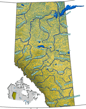
 Map of the Peace River watershed in western Canada | |
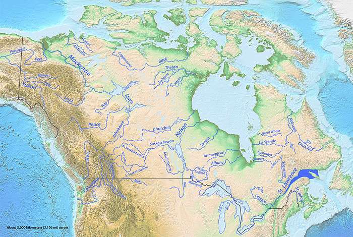
The Peace River (French: rivière de la Paix) is a river in Canada that originates in the Rocky Mountains of northern British Columbia and flows to the northeast through northern Alberta. The Peace River flows into the Slave River, a tributary of the Mackenzie River. The Mackenzie is the 12th longest river in the world, preceded by the Mekong and followed by the Niger River. The Finlay River, the main headwater of the Peace River, is regarded as the ultimate source of the Mackenzie River.
History
The regions along the river are the traditional home of the Danezaa people, called the Beaver by the Europeans. The fur trader Peter Pond is believed to have visited the river in 1785. In 1788 Charles Boyer of the North West Company established a fur trading post at the river's junction with the Boyer River.
In 1792 and 1793, the explorer Alexander Mackenzie travelled up the river to the Continental Divide.[3] Mackenzie referred to the river as Unjegah, from a native word meaning "large river".
The decades of hostilities between the Danezaa and the Cree, (in which the Cree dominated the Danezaa), ended in 1781 when a smallpox epidemic decimated the Cree. The Treaty of the Peace was celebrated by the smoking of a ceremonial pipe. The treaty made the Peace River a border, with the Danezaa to the North and the Cree to the South.[4]
In 1794, a fur trading post was built on the Peace River at Fort St. John; it was the first non-native settlement on the British Columbia mainland.
Post-Settlement
The rich soils of the Peace River valley in Alberta have been producing wheat crops since the late 19th century. The Peace River region is also an important centre of oil and natural gas production. There are also pulp and paper plants along the river in Alberta and British Columbia.

The Peace River has two navigable sections, separated by the Vermilion Chutes, near Fort Vermilion.[5] The first steam-powered vessel to navigate the Peace River was the Grahame, a Hudson's Bay Company vessel built at Fort Chipewyan, on Lake Athabasca. Brothers of the Oblate Order of Mary Immaculate, built the St. Charles, to navigate the upper reaches of the River, from Fort Vermilion to Hudson's Hope. Approximately a dozen vessels were to navigate the river. Most of the early vessels were wood-burning steamships, fueled by wood cut from the river's shore. The last cargo vessel was the Watson's Lake, retired in 1952.
Geography
Course
This river is 1,923 kilometres (1,195 mi) long (from the head of Finlay River to Lake Athabasca). It drains an area of approximately 302,500 square kilometres (116,800 sq mi).[6] At Peace Point, where it drains in the Slave River, it has an annual discharge of 68.2 billion cubic metres (55,300,000 acre·ft).[7]
A large man-made lake, Williston Lake, has been formed on the upper river by the construction of the W. A. C. Bennett Dam for hydroelectric power generation. The river then flows into Dinosaur Lake, which serves as a reservoir for the Peace Canyon Dam. After the dams, the river flows east into Alberta and then continues north and east into the Peace-Athabasca Delta in Wood Buffalo National Park, at the western end of Lake Athabasca. Water from the delta flows into the Slave River east of Peace Point and reaches the Arctic Ocean via the Great Slave Lake and Mackenzie River.
Communities


Communities located directly on the river include:
- Hudson's Hope, British Columbia
- Taylor, British Columbia
- Peace River, Alberta
- Fort Vermilion, Alberta
Many provincial parks and wildland reserves are established on the river, such as Butler Ridge Provincial Park, Taylor Landing Provincial Park, Beatton River Provincial Park, Peace River Corridor Provincial Park in British Columbia and Dunvegan Provincial Park, Dunvegan West Wildland, Peace River Wildland Provincial Park, Greene Valley Provincial Park, Notikewin Provincial Park, Wood Buffalo National Park in Alberta.
A few Indian reserves are also located on the river banks, among them Beaver Ranch 163, John D'Or Prairie 215, Fox Lake 162, Peace Point 222 and Devil's Gate 220.
Tributaries
Tributaries of the Peace River include:
- Finlay River
- Omineca River
- Ingenika River
- Ospika River
- Parsnip River
- Manson River
- Nation River
- Clearwater Creek
- Nabesche River
- Carbon Creek
- Northeastern British Columbia
- Gething Creek, Moosbar Creek, Johnson Creek, Starfish Creek, Bullrun Creek, Portage Creek, Maurice Creek, Lynx Creek, Farrell Creek
- Halfway River
- Cache Creek, Wilder Creek, Tea Creek
- Moberly River
- Pine River
- Eight Mile Creek
- Beatton River
- Golata Creek, Mica Creek
- Kiskatinaw River
- Alces River
- Alberta
- Moonlight Creek
- Pouce Coupe River
- Clear River
- Sneddon Creek
- Montagneuse River
- Fourth Creek, Hamelin Creek
- Ksituan River
- Hines Creek, Dunvegan Creek, Boucher Creek
- Leith River (Little Burnt River)
- Saddle River (Burnt River)
- Griffin Creek, Mcallister Creek, Strong Creek
- Smoky River
- Heart River
- Pats Creek, Three Creeks, Carmon Creek
- Whitemud River
- Cadotte River
- Buchanan Creek, Keppler Creek
- Notikewin River
- Scully Creek
- Wolverine River
- Buffalo River
- Keg River
- Steephill Creek
- Boyer River
- Caribou River
- Beaver Ranch Creek
- Wabasca River
- Lawrence River
- Mikkwa River (Little Red River)
- Dummy Creek, Waldo Creek
- Pakwanutik River
- Garden Creek, Drolet Creek, Swan River, Vermilion River, Trident Creek, Portage River
- Jackfish River
- Jodoin Creek
- Claire River
- Lake Claire
- Lake Claire
- Birch River
- McIvor River
- Mamawi Lake
- Baril River
- Chenal Des Quatre Fourches
- Revolution Coupe
- Scow Channel
See also
- List of rivers of Alberta
- List of rivers of British Columbia
- List of longest rivers of Canada
- Steamboats of the Peace River
References
- ↑ Bennett, R.M.; Card, J.R.; Hornby, D.M. (1973-03-09). "Hydrology of Lake Athabasca: Past, Present and Future" (PDF). Hydrological Sciences Bulletin, XVIII. International Association of Hydrological Science. Retrieved 2010-10-08.
- ↑ "Peace River at Peace Point". R-ArcticNet. 1959–2000. Retrieved 2010-10-08.
- ↑ "Peace River", Encyclopædia Britannica, 2006. Retrieved September 12, 2006, from Encyclopædia Britannica Premium Service
- ↑ Coutts, M. E. (1958). Dawson Creek: Past and Present, An Historical Sketch. Edmonton: Dawson Creek Historical Society.
- ↑ Edward L. Affleck. "Steamboating on the Peace River" (PDF). British Columbia History. Archived (PDF) from the original on 2012-12-06.
The brothers built a fleet of small primitive steamers, extending by 1903 to the waters of the Peace above the Vermilion Chutes. In that year the pint—sized sternwheeler St. Charles began to work the 526 mile stretch from Fort Vermilion to Hudson’s Hope, carrying lumber and supplies for the Mission at Fort St. John in British Columbia, as well as goods for the Northwest Mounted Police.
- ↑ Atlas of Canada. "Rivers in Canada". Retrieved 2007-05-01.
- ↑ Alberta Environment - Alberta river basins
External links
| Wikisource has the text of a 1911 Encyclopædia Britannica article about Peace River. |