Paulínia
Coordinates: 22°45′40″S 47°09′15″W / 22.76111°S 47.15417°W
| Paulínia | |||
|---|---|---|---|
| Municipality | |||
| The Municipality of Paulínia | |||
 | |||
| |||
 Location of Paulinia | |||
 Paulínia Location in Brazil | |||
| Coordinates: 22°45′40″S 47°09′15″W / 22.76111°S 47.15417°W | |||
| Country |
| ||
| Region | Southeast | ||
| State | São Paulo | ||
| Metropolitan Region | Campinas | ||
| Founded | 16 July 1906 | ||
| Government | |||
| • Mayor | José Pavan Junior | ||
| Area[1] | |||
| • Total | 138.78 km2 (53.58 sq mi) | ||
| Elevation | 590 m (1,940 ft) | ||
| Population (2015)[1] | |||
| • Total | 100,128 | ||
| • Density | 720/km2 (1,900/sq mi) | ||
| Time zone | BRT (UTC-3) | ||
| • Summer (DST) | BRST (UTC-2) | ||
| Postal Code | 13140-001 to 13159-999 | ||
| Area code(s) | +55 19 | ||
| Website | Paulinia, São Paulo | ||


Paulínia is a municipality in the state of São Paulo in Brazil. It is part of the Metropolitan Region of Campinas.[2] The population is 100,128 (2016 est.) in an area of 138.78 km².[1] The elevation is 590 m. It is known for hosting the Replan, the largest refinery of Petrobras.[3]
History
The municipality was created in 1964 from a part of the municipality of Campinas.
Sports
Paulínia Futebol Clube is the municipality's football club. They play their home games at Estádio Municipal Luís Perissinoto.
Neighborhoods
The municipality contains part of the Mata de Santa Genebra, an area of relevant ecological interest.[4]
See also
- Theatro Municipal de Paulínia
- Atibaia River
- Jaguari River
- Escola Técnica de Paulínia
- Paulínia Shopping
Gallery
 Condominiums at Morumbi neighborhood
 Municipal Theater
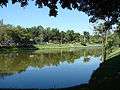 Zeca Malavazzi Park
 Estadio M. Luís Perissinoto
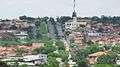 Antônio Batista Piva Avenue
References
- 1 2 3 Instituto Brasileiro de Geografia e Estatística
- ↑ Região Metropolitana de Campinas
- ↑ "Replan Refinery, Brazil". Hydrocarbons-technology.com. Kable. Retrieved 10 August 2014.
- ↑ Unidade de Conservação: Área de Relevante Interesse Ecológico Mata de Santa Genebra (in Portuguese), MMA: Ministério do Meio Ambiente, retrieved 2016-05-08
| Wikimedia Commons has media related to Paulínia. |
This article is issued from Wikipedia - version of the 11/29/2016. The text is available under the Creative Commons Attribution/Share Alike but additional terms may apply for the media files.