Patoka Township, Gibson County, Indiana
| Patoka Township Gibson County | |
|---|---|
| Township | |
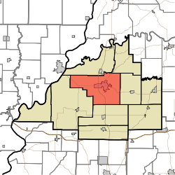 Location of Patoka Township within Gibson County | |
| Coordinates: 38°21′03″N 87°35′28″W / 38.35083°N 87.59111°WCoordinates: 38°21′03″N 87°35′28″W / 38.35083°N 87.59111°W | |
| Country | United States |
| State | Indiana |
| County | Gibson |
| Named for | Patoka River |
| Government | |
| • Type | Indiana township |
| • Trustee | Brad Schmitt |
| Area | |
| • Total | 68.92 sq mi (178.5 km2) |
| • Land | 68.49 sq mi (177.4 km2) |
| • Water | 0.43 sq mi (1.1 km2) |
| Elevation[1] | 446 ft (136 m) |
| Population (2014) Population-wise Largest Township | |
| • Total | 11,880 |
| • Density | 172.37/sq mi (66.55/km2) |
| Time zone | CST (UTC-6) |
| • Summer (DST) | CDT (UTC-5) |
| ZIP codes | 47670 47671 |
| Area code(s) | 812 - 385 / 386 / 387 / 388 / 724 / 779 |
| FIPS code | 18-58338[2] |
| GNIS feature ID | 453709 |
| Largest Township in Gibson County by population | |
Patoka Township is one of ten townships in Gibson County, Indiana, United States. As of the 2010 census, its population was 11,864 and it contained 5,341 housing units.[3]
History
Patoka Township was organized in 1813.[4] It took its name from the Patoka River.[5]
The Lyles Consolidated School was listed on the National Register of Historic Places in 1999.[6]
Geography
According to the 2010 census, the township has a total area of 68.92 square miles (178.5 km2), of which 68.49 square miles (177.4 km2) (or 99.38%) is land and 0.43 square miles (1.1 km2) (or 0.62%) is water.[3]
Cities and towns
- Princeton (the county seat and largest community)
Unincorporated towns
(This list is based on USGS data and may include former settlements.)
Adjacent townships
- White River Township (north)
- Washington Township (northeast)
- Center Township (east)
- Union Township (south)
- Montgomery Township (southwest)
Cemeteries
The township contains seven cemeteries: Archer, Hitch, Maple Hill, Odd Fellows, Saint Josephs, Sand Hill and Warnock.
Major highways
Education
Public education in Patoka Township is administered by the North Gibson School Corporation.
Public Schools
- Brumfeld Elementary School
- Lowell Elementary School
- Princeton Community Middle School
- Princeton Community High School
Private Schools
- St. Joseph Catholic School
Higher Education
- Vincennes University Workforce Development
Museums
- Lyles Station Schoolhouse Museum - Lyles Station (2 miles WNW of Princeton)
References
- ↑ "US Board on Geographic Names". United States Geological Survey. 2007-10-25. Retrieved 2008-01-31.
- ↑ "American FactFinder". United States Census Bureau. Archived from the original on September 11, 2013. Retrieved 2008-01-31.
- 1 2 "Population, Housing Units, Area, and Density: 2010 - County -- County Subdivision and Place -- 2010 Census Summary File 1". United States Census. Retrieved 2013-05-10.
- ↑ Stormont, Gil R. (1914). History of Gibson County, Indiana: Her People, Industries and Institutions. B.F. Bowen. p. 340.
- ↑ History of Gibson County, Indiana: With Illustrations Descriptive of Its Scenery, and Biographical Sketches of Some of Its Prominent Men and Pioneers. Jas. T. Tartt & Co. 1884. p. 153.
- ↑ National Park Service (2010-07-09). "National Register Information System". National Register of Historic Places. National Park Service.
External links
Municipalities and communities of Gibson County, Indiana, United States | ||
|---|---|---|
| Cities | 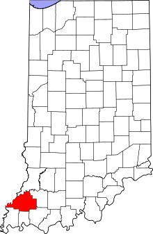 | |
| Towns | ||
| Townships | ||
| Unincorporated communities | ||
| Ghost town | ||