Pati Regency
For the term meaning "master/lord" in Indo-Iranian languages, see Pati (title).
| Pati Regency Kabupaten Pati | ||
|---|---|---|
| Regency | ||
| ||
| Motto: Pati Bumi Mina Tani | ||
 Location of Pati Regency in Central Java | ||
 Pati Regency Location of Pati Regency in Indonesia | ||
| Coordinates: 7°35′46″S 110°57′3″E / 7.59611°S 110.95083°ECoordinates: 7°35′46″S 110°57′3″E / 7.59611°S 110.95083°E | ||
| Country | Indonesia | |
| Province | Central Java | |
| Capital | Pati | |
| Government | ||
| • Regent | Haryanto | |
| Area | ||
| • Total | 1,489.19 km2 (574.98 sq mi) | |
| Population (2014) | ||
| • Total | 1,205,601 | |
| • Density | 810/km2 (2,100/sq mi) | |
| Time zone | WIB (UTC+7) | |
| Area code(s) | +62 295 | |
| Website | www.patikab.go.id | |

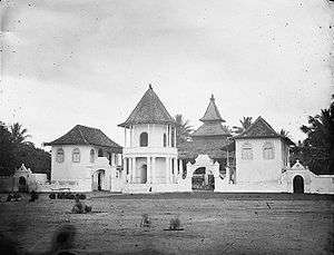
Pati mosque (1900-1940)
Pati Regency is a regency (Indonesian: kabupaten) in the northeastern part of Central Java province in Indonesia. It covers an area of 1,489.19 km2, and it had a population of 1,190,993 at the 2010 Census;[1] the latest official estimate (as at January 2014) is 1,205,601. Its administrative capital is the town of Pati.
Administrative districts
The regency is divided into twenty-one districts (kecamatan), tabulated below:
- Batangan
- Cluwak
- Dukuhseti
- Gabus
- Gembong
- Gunungwungkal
- Jaken
- Jakenan
- Juwana
- Kayen
- Margorejo
- Margoyoso
- Muktiharjo
- Pati
- Pucakwangi
- Sukolilo
- Tambakromo
- Tayu
- Tlogowungu
- Trangkil
- Wedarijaksa
- Winong
Tourism
- Santi Waterfall
- Grenjengan Sewu Waterfall

Air Terjun Puncak Tinggi
- Tadah Hujan Waterfall
- Peak Waterfall (Air Terjun Puncak)
- Wareh cave
- Pancur Cave
- Gunung Rowo Lake
- Seloromo Lake
- Argo Jembangan Peak

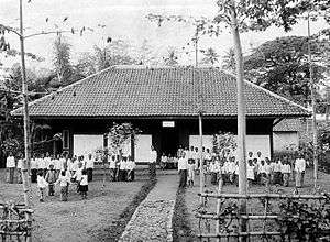
A school in Pati colonial period.
Regencies and cities of Central Java | ||
|---|---|---|
Capital: Semarang | ||
| Regencies |  | |
| Cities | ||
| Villages | ||
References
- ↑ Biro Pusat Statistik, Jakarta, 2011.
This article is issued from Wikipedia - version of the 9/18/2016. The text is available under the Creative Commons Attribution/Share Alike but additional terms may apply for the media files.