Pateros, Metro Manila
| Pateros | ||
|---|---|---|
| Municipality | ||
| Bayan ng Pateros | ||
 | ||
| ||
| Nickname(s): A Small Town with a Big Heart; Balut Capital of the Philippines; Home of the World Famous Balut | ||
| Motto: Mas na Mas, Pateros! (literally, The Superb Pateros) | ||
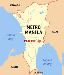 Location within Metro Manila | ||
.svg.png) Pateros Location within the Philippines | ||
| Coordinates: 14°32′30″N 121°04′00″E / 14.5417°N 121.0667°ECoordinates: 14°32′30″N 121°04′00″E / 14.5417°N 121.0667°E | ||
| Country | Philippines | |
| Region | National Capital Region | |
| Districts | Lone district of Taguig City-Pateros | |
| Founded | 1770 | |
| Independent Municipality | January 1, 1909 | |
| Barangays | 10 | |
| Government[1] | ||
| • Mayor | Miguel "Ike" Ponce III (Liberal) | |
| • Vice Mayor | Gerald German (Liberal) | |
| • Sangguniang Bayan |
Councilors
| |
| Area[2][3] | ||
| • Total | 1.76 km2 (0.68 sq mi) | |
| Elevation | 16.0 m (52.5 ft) | |
| Population (2015 census)[4] | ||
| • Total | 63,840 | |
| • Density | 36,000/km2 (94,000/sq mi) | |
| Time zone | PST (UTC+8) | |
| Zip Code | 1620–1622 | |
| Area code | +63 (0)02 | |
| Website |
www | |

Pateros, officially the Municipality of Pateros (Filipino: Bayan ng Pateros), is a first-class municipality in Metro Manila, Philippines. According to the 2015 census, it has a population of 63,840.[4]
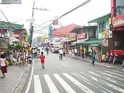
This small town is famous for its duck-raising industry and especially for producing balut, a Filipino delicacy that is boiled duck egg. Pateros is also known for the production of red salty eggs and "inutak", a local rice cake. Moreover, the town is known for manufacturing of "alfombra", a locally-made footwear with a carpet-like fabric on its top surface. Pateros is bordered by Pasig City to the north, Makati City to the west, and Taguig City to the south.
Pateros is the only municipality and the smallest, both in population and in land area, in Metro Manila, but it is the second most densely populated at around 29 thousand people per square kilometer after Manila.
It is the smallest municipality in terms of land area in the Philippines.
Etymology
The name Pateros most likely derived from the duck-raising industry. The Tagalog loanword (of Spanish origin) for "duck" is pato and pateros means "duck-raisers". The early 19th-century U.S. diplomat Edmund Roberts used Duck-town, another name for Pateros, stating that he "never before saw so many ducks together" in one place.[5]
Another, lesser-known theory is that the name may allude to the town's small shoemaking industry. The Tagalog word for "shoe"—also of Spanish origin—is sapatos, and shoemakers are called sapateros.
History
Before 1770, Pateros was only a barrio of Pasig until the Spanish Governor-General of the Philippines issued a decree making Pateros an independent municipality. The town was then composed of five barangays (villages): Aguho, San Roque, Santa Ana, Santo Rosario, and Mamancat (now part of Fort Bonifacio).
On March 29, 1900, Pateros became one of the towns in the newly created province of Rizal, by virtue of General Order No. 40, Act No. 137 of the Philippine Commission, which was promulgated on June 11, 1901. Then on October 12, 1903, Act No. 942 united Pateros with Taguig and Muntinlupa into one municipality under Pateros. The municipality was renamed Taguig on March 22, 1905, through Act No. 1308.
Executive Order No. 20 dated February 29, 1908 partitoned Pateros from Taguig, and the town regained independent status as a municipality on January 1, 1909, by Executive Order No. 36. On November 7, 1975, Pateros became a part of the new Metropolitan Manila Area through Presidential Decree No. 824.[6]
Geography
Barangays
Pateros is politically subdivided into 10 barangays:
- Aguho
- Magtanggol
- Martires Del 96
- Poblacion - this barangay serves as the town's commercial center
- San Pedro
- San Roque
- Santa Ana
- Santo Rosario-Kanluran
- Santo Rosario-Silangan
- Tabacalera
Boundary dispute
The municipal government of Pateros claims that its original land area was not its present land area of 2.10 km² but 1,040 hectares (10.4 km²) including Fort Bonifacio, particularly Barangays Comembo, Pembo, East Rembo, West Rembo, Cembo, South Cembo and Pitogo which are now part of the city of Makati and Bonifacio Global City (known as Post Proper Northside by Makati) which was made part of Taguig, based on documents and official maps obtained by former Pateros Councilor Dominador Rosales from 30 libraries and offices including USA Library of Congress and USA Archives. One of those maps was the 1968 Land Classification Map of the Bureau of Land.[7]
Pateros’ decrease in territory was accounted to a cadastral mapping in Metro Manila conducted in 1978. The late Pateros Mayor Nestor Ponce challenged the map through an objection letter dated June 23, 1978.[8] But on January 1986, former President Ferdinand Marcos issued Proclamation No. 2475 which stated that Fort Bonifacio is situated in Makati and it is open for disposition.[9] Because of that, a boundary dispute arose which moved Pateros to request a dialogue about that with then Municipal Council of Makati in 1990. Pateros also filed a complaint against Makati at the Makati Regional Trial Court in 1996 but the trial court dismissed the case for lack of jurisdiction. The case was brought to the Court of Appeals in 2003 but the case was also denied. The same case was also elevated to the Supreme Court in 2009 but it was denied again.[7][10]
Supreme Court Decision
Almost 2 decades later, the Supreme Court on June 16, 2009, per Antonio Eduardo B. Nachura denied Pateros’ petition against Makati but ruled out that the boundary dispute should be settled amicably by their respective legislative bodies based on Section 118(d) of the Local Government Code.[11] Pursuant to the decision, Pateros invited Makati to a council-to-council dialogue. This happened on October 8, 2009. Four meetings were held and at the fourth dialogue on November 23, 2009, a joint resolution was made stating that Makati is requesting a tripartite conference between Pateros, Taguig and Makati.[12]
Demographics
As of 1818, the population was estimated at 3,840 Tagalog peoples. When Edmund Roberts visited in 1834, he estimated approximately 4,500 residents.[5]
| Population Census of Pateros | |||||||||||||||||||||||||
|---|---|---|---|---|---|---|---|---|---|---|---|---|---|---|---|---|---|---|---|---|---|---|---|---|---|
|
| ||||||||||||||||||||||||
| Source: National Statistics Office[4][13] | |||||||||||||||||||||||||

Economy
As of 1834, Pateros raised and sold duck and had a fishing industry.[5]

.jpg)

Education
Colleges in the municipality includes Pateros Technological College and St. John Bosco College.
Notable people
- Jimmy Santos - Filipino Actor, PBA Basketball Player, and TV Host, Eat Bulaga!
- Berting Labra - Actor, Side kick of FPJ
- Daisy Reyes - Beauty Queen, Actress
- Socrates Villegas - Archbishop of Lingayen-Dagupan, CBCP President
References
- ↑ "Municipalities". Quezon City, Philippines: Department of the Interior and Local Government. Retrieved 30 November 2012.
- ↑ "An Update on the Earthquake Hazards and Risk Assessment of Greater Metropolitan Manila Area" (PDF). Philippine Institute of Volcanology and Seismology. November 14, 2013. Retrieved May 16, 2016.
- ↑ "Enhancing Risk Analysis Capacities for Flood, Tropical Cyclone Severe Wind and Earthquake for the Greater Metro Manila Area Component 5 – Earthquake Risk Analysis" (PDF). Philippine Institute of Volcanology and Seismology and Geoscience Australia. Retrieved May 16, 2016.
- 1 2 3 "NATIONAL CAPITAL REGION (NCR)". Census of Population (2015): Total Population by Province, City, Municipality and Barangay (Report). PSA. Retrieved 20 June 2016.
- 1 2 3 Roberts, Edmund (1837). Embassy to the Eastern Courts of Cochin-China, Siam, and Muscat. New York: Harper & Brothers. pp. 63–64.
- ↑ "Historical background". Municipal Government of Pateros. Retrieved 5 December 2012.
- 1 2 Rosales, D. 2009, November. Sanhi ng pagliit ng Pateros. Susi ng Pateros, 5.
- ↑ Bayos, Kris. 2009, October 8. Documents back up Pateros’ claim over 7 Makati villages. Manila Bulletin.
- ↑ Tuazon, L. 2000, January. LC 2623 map: Isang katotohanang hindi matitinag. Susi ng Pateros, 3.
- ↑ Supreme Court Decision for Pateros' petition to claim Fort Bonifacio. Retrieved from http://sc.judiciary.gov.ph/jurisprudence/2009/june2009/157714.htm
- ↑ Panaligan, R. 2009, June 22. SC wants Ft. Bonifacio land dispute settled amicably. Manila Bulletin.
- ↑ Rosales, D. 2010, April. Update: Fort Bonifacio claim. Susi ng Pateros, 1 & 4.
- ↑ "Population and Annual Growth Rates for The Philippines and Its Regions, Provinces, and Highly Urbanized Cities" (PDF). 2010 Census and Housing Population. National Statistics Office. Archived from the original (PDF) on September 28, 2013. Retrieved 2012-11-07.
External links
| Wikimedia Commons has media related to Pateros, Metro Manila. |
- Municipality of Pateros official website
- Facts of Balut and City of Pateros
 Geographic data related to Pateros, Metro Manila at OpenStreetMap
 |
Pasig | | ||
| Makati | |
|||
| ||||
| | ||||
| |
Taguig |