Pass Cavallo (Texas)
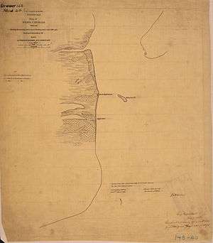
Civil War map Showing the position of the Rebel fortifications and rifle pits

Pass Cavallo upper right corner
Pass Cavallo, alternately known as Cavallo Pass, is one of five natural water inlets which separate the Gulf of Mexico and Matagorda Bay, in the U.S. state of Texas.[1] René-Robert Cavelier, Sieur de La Salle came ashore in Texas at this point.[2] Matagorda Island Lighthouse was originally built on this site.[3] During the Civil War, Pass Cavallo was a major port of entry and was captured by the Union[4] Coordinates: 28°23′N 96°24′W / 28.383°N 96.400°W
References
- ↑ "Matagorda Bay". Texas A & M University, Corpus Christi. Retrieved 13 September 2011.
- ↑ Sorrells, Colby (2009). Flyfishers Guide to Texas Golf Coast. Wilderness Adventures Press. p. 131. ISBN 978-1-932098-66-2.
- ↑ "Matagorda Island Lighthouse". Texas State Historical Association. Retrieved 13 September 2011.
- ↑ Underwood, Rodman L (2008). Waters of Discord: The Union Blockade of Texas During the Civil War. McFarland. pp. 7, 78, 79. ISBN 978-0-7864-3776-4.
This article is issued from Wikipedia - version of the 4/8/2015. The text is available under the Creative Commons Attribution/Share Alike but additional terms may apply for the media files.