Pas-en-Artois
| Pas-en-Artois | |
|---|---|
|
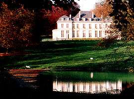
Chateau | |
 Pas-en-Artois | |
|
Location within Hauts-de-France region  Pas-en-Artois | |
| Coordinates: 50°09′20″N 2°29′24″E / 50.1556°N 2.49°E / 50.1556; 2.49Coordinates: 50°09′20″N 2°29′24″E / 50.1556°N 2.49°E / 50.1556; 2.49 | |
| Country | France |
| Region | Hauts-de-France |
| Department | Pas-de-Calais |
| Arrondissement | Arras |
| Canton | Pas-en-Artois |
| Intercommunality | Deux Sources |
| Government | |
| • Mayor (2008–2014) | François Lefel |
| Area1 | 10.88 km2 (4.20 sq mi) |
| Population (2006)2 | 839 |
| • Density | 77/km2 (200/sq mi) |
| Time zone | CET (UTC+1) |
| • Summer (DST) | CEST (UTC+2) |
| INSEE/Postal code | 62.49 / 62760 |
| Elevation |
80–158 m (262–518 ft) (avg. 98 m or 322 ft) |
|
1 French Land Register data, which excludes lakes, ponds, glaciers > 1 km² (0.386 sq mi or 247 acres) and river estuaries. 2 Population without double counting: residents of multiple communes (e.g., students and military personnel) only counted once. | |
Pas-en-Artois is a commune in the Pas-de-Calais department in the Hauts-de-France region of France.
Geography
Pas-en-Artois is situated 16 miles (26 km) southwest of Arras, at the junction of the D1, D6 and D25 roads, in the valley of the river Kilienne, a small tributary of the Authie.
Population
| 1962 | 1968 | 1975 | 1982 | 1990 | 1999 | 2006 |
|---|---|---|---|---|---|---|
| 859 | 913 | 959 | 948 | 925 | 938 | 839 |
| Census count starting from 1962: Population without duplicates | ||||||
Places of interest
- The church of St.Martin, dating from the seventeenth century.
- The seventeenth-century chateau.

The church
See also
References
External links
| Wikimedia Commons has media related to Pas-en-Artois. |
- Pas-en-Artois on the Quid website (French)
This article is issued from Wikipedia - version of the 11/8/2016. The text is available under the Creative Commons Attribution/Share Alike but additional terms may apply for the media files.