Parrsboro
| Parrsboro | |||||
|---|---|---|---|---|---|
| Town | |||||
|
Main Street Parrsboro | |||||
| |||||
| Motto: Parrsboro 'Rocks' | |||||
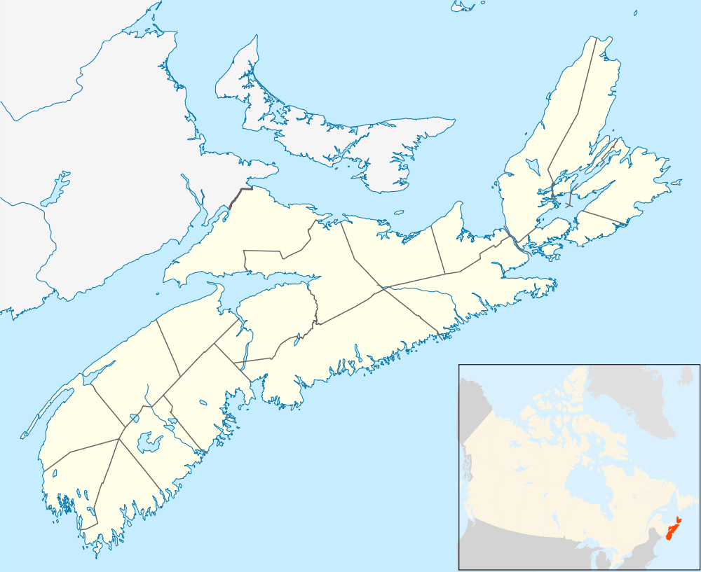 Parrsboro Location of Parrsboro | |||||
| Coordinates: 45°24′21″N 64°19′33″W / 45.40583°N 64.32583°WCoordinates: 45°24′21″N 64°19′33″W / 45.40583°N 64.32583°W | |||||
| Country |
| ||||
| Province |
| ||||
| Municipality | Cumberland County | ||||
| Founded | 1670 | ||||
| Incorporated | July 15, 1889 | ||||
| Electoral Districts Federal |
Cumberland-Colchester-Musquodoboit Valley | ||||
| Provincial | Cumberland South | ||||
| Government | |||||
| • Mayor | Lois Smith | ||||
| • Governing Body | Parrsboro Town Council | ||||
| • MLA | Jamie Baillie (PC) | ||||
| • MP | Bill Casey (L) | ||||
| Area | |||||
| • Total | 14.88 km2 (5.75 sq mi) | ||||
| Highest elevation | 47 m (154 ft) | ||||
| Lowest elevation | 0 m (0 ft) | ||||
| Population (2011) | |||||
| • Total | 1,305 | ||||
| • Density | 87.7/km2 (227/sq mi) | ||||
| Time zone | AST (UTC-4) | ||||
| • Summer (DST) | ADT (UTC-3) | ||||
| Postal code | B0M 1S0 | ||||
| Area code(s) | 902 | ||||
| Telephone exchange | 254 | ||||
| Median Earnings* | $27,472 | ||||
| NTS Map | 021H08 | ||||
| GNBC Code | CBCYW | ||||
| Website | town.parrsboro .ns.ca | ||||
| |||||


Parrsboro is a Canadian town located in Cumberland County, Nova Scotia.
The town is known for its port on the Minas Basin, the Ship's Company Theatre productions and the Fundy Geological Museum.
History
Before the arrival of European settlers, Parrsboro was a portage point for Mikmaq travellers along the Minas Basin and Cumberland County river systems. The native inhabitants called the region "Awokum," meaning a 'short-cut' or 'passing-over point.'[1]
The first European settlers were the Acadians in 1670 at the western mouth of the Parrsboro Harbour, near Partridge Island. After they were expelled in 1755, they were replaced by New England Planters.[2] The centre of settlement gradually shifted from Partridge Island to the sheltered estuary of the Parrsboro River where a harbour and surrounding mills grew. The settlement, at first named Mill Village, was renamed Parrsboro in honour of Nova Scotia Governor John Parr in 1784, and the town was incorporated on July 15, 1889.[3]

Parrsboro thrived in the mid 19th century as the hub of a string of shipbuilding communities from Economy to Advocate collectively known as the "Parrsboro Shore". The town became a port of registry in 1850 for over 115 locally built schooners as well as giant square riggers, culminating in the largest, the ship Glooscap in 1891. In its peak years of the 1890s, over 1646 ships arrived and departed annually.[4]
The Springhill and Parrsboro Railway began service to the town from the coal mining town of Springhill on July 1, 1877; Parrsboro became a coal shipping port for the Springhill mines, primarily serving Saint John, New Brunswick. Railway service to Parrsboro was abandoned on June 14, 1958, following several years of declining shipments, several months before the 1958 mining disaster.[5]
Throughout the late 19th century and first four decades of the twentieth century, Parrsboro saw daily ferry service across the Minas Basin to the Annapolis Valley ports of Kingsport and Wolfville. The 13th and final vessel in this service, operated by the Dominion Atlantic Railway, was the MV Kipawo, which is now permanently beached at Parrsboro and incorporated into the Ship's Company Theatre performance centre.[6]
A Handley Page V/1500 named Atlantic made a forced landing in Parrsboro July 5, 1919. When the starboard engine failed the pilot, Major Brackley saw the lights of the town during the night and landed. After three months, the aircraft was repaired and departed for Greenport, New York, Parrsboro's sister town.[7] The local Air Cadet Squadron, 689 Handley Page, is named after this event.
On April 10, 1984, Parrsboro resident Eldon George located the world's smallest dinosaur footprints at Wasson Bluff, a series of cliffs to the east of Parrsboro Harbour. The prints are now on display at the Parrsboro Rock and Mineral Shop and Museum, owned by George.[8]
Climate
| Climate data for Parrsboro, 1981–2010 normals, extremes 1897–present | |||||||||||||
|---|---|---|---|---|---|---|---|---|---|---|---|---|---|
| Month | Jan | Feb | Mar | Apr | May | Jun | Jul | Aug | Sep | Oct | Nov | Dec | Year |
| Record high °C (°F) | 17.0 (62.6) |
16.9 (62.4) |
20.0 (68) |
27.2 (81) |
31.0 (87.8) |
31.7 (89.1) |
33.3 (91.9) |
33.3 (91.9) |
29.4 (84.9) |
27.4 (81.3) |
22.0 (71.6) |
18.9 (66) |
33.3 (91.9) |
| Average high °C (°F) | −1.5 (29.3) |
−0.8 (30.6) |
2.7 (36.9) |
8.5 (47.3) |
14.9 (58.8) |
19.5 (67.1) |
22.7 (72.9) |
22.6 (72.7) |
18.7 (65.7) |
13.0 (55.4) |
7.6 (45.7) |
1.6 (34.9) |
10.8 (51.4) |
| Daily mean °C (°F) | −6.1 (21) |
−5.4 (22.3) |
−1.5 (29.3) |
4.2 (39.6) |
9.7 (49.5) |
14.2 (57.6) |
17.5 (63.5) |
17.6 (63.7) |
14.1 (57.4) |
8.7 (47.7) |
3.5 (38.3) |
−2.5 (27.5) |
6.2 (43.2) |
| Average low °C (°F) | −10.7 (12.7) |
−10.0 (14) |
−5.7 (21.7) |
−0.2 (31.6) |
4.5 (40.1) |
8.8 (47.8) |
12.1 (53.8) |
12.5 (54.5) |
9.4 (48.9) |
4.4 (39.9) |
−0.2 (31.6) |
−6.7 (19.9) |
1.5 (34.7) |
| Record low °C (°F) | −35.6 (−32.1) |
−35.0 (−31) |
−27.2 (−17) |
−23.9 (−11) |
−9.4 (15.1) |
−3.9 (25) |
−0.6 (30.9) |
−3.9 (25) |
−5.6 (21.9) |
−11.7 (10.9) |
−23.3 (−9.9) |
−31.7 (−25.1) |
−35.6 (−32.1) |
| Average precipitation mm (inches) | 115.0 (4.528) |
89.2 (3.512) |
114.7 (4.516) |
103.6 (4.079) |
105.2 (4.142) |
102.3 (4.028) |
89.6 (3.528) |
86.2 (3.394) |
113.2 (4.457) |
108.7 (4.28) |
120.4 (4.74) |
121.7 (4.791) |
1,269.7 (49.988) |
| Average rainfall mm (inches) | 54.1 (2.13) |
40.4 (1.591) |
69.2 (2.724) |
86.6 (3.409) |
103.8 (4.087) |
102.3 (4.028) |
89.6 (3.528) |
86.2 (3.394) |
113.2 (4.457) |
108.6 (4.276) |
109.9 (4.327) |
75.7 (2.98) |
1,039.4 (40.921) |
| Average snowfall cm (inches) | 60.9 (23.98) |
48.8 (19.21) |
45.5 (17.91) |
17.0 (6.69) |
1.4 (0.55) |
0.0 (0) |
0.0 (0) |
0.0 (0) |
0.0 (0) |
0.1 (0.04) |
10.6 (4.17) |
46.0 (18.11) |
230.3 (90.67) |
| Average precipitation days (≥ 0.2 mm) | 15.8 | 13.5 | 14.8 | 16.3 | 16.2 | 15.1 | 13.4 | 13.4 | 13.2 | 15.0 | 17.5 | 17.0 | 181.1 |
| Average rainy days (≥ 0.2 mm) | 7.6 | 6.2 | 9.6 | 14.8 | 16.1 | 15.1 | 13.4 | 13.4 | 13.2 | 15.0 | 16.3 | 10.7 | 151.4 |
| Average snowy days (≥ 0.2 cm) | 10.8 | 9.6 | 8.0 | 3.4 | 0.36 | 0.0 | 0.0 | 0.0 | 0.0 | 0.05 | 2.6 | 8.7 | 43.4 |
| Source: Environment Canada[9][10] | |||||||||||||
Town features
| Historical population | ||
|---|---|---|
| Year | Pop. | ±% |
| 1881 | 1,206 | — |
| 1891 | 1,909 | +58.3% |
| 1901 | 3,391 | +77.6% |
| 1911 | 2,856 | −15.8% |
| 1921 | 2,748 | −3.8% |
| 1931 | 1,919 | −30.2% |
| 1941 | 1,971 | +2.7% |
| 1951 | 1,906 | −3.3% |
| 1956 | 1,849 | −3.0% |
| 1961 | 1,834 | −0.8% |
| 1981 | 1,799 | −1.9% |
| 1986 | 1,729 | −3.9% |
| 1991 | 1,634 | −5.5% |
| 1996 | 1,617 | −1.0% |
| 2001 | 1,529 | −5.4% |
| 2006 | 1,401 | −8.4% |
| 2011 | 1,305 | −6.9% |
| [11] [12][13][14][15][16] | ||
As with much of rural Nova Scotia, the primary industry in Parrsboro is tourism. The town is known for its seasonal theatre productions, fossil and rockhounding attractions, museums, high tides and heritage buildings. The cliffs to the east and west of Parrsboro contain fossils of prehistoric animals and plants. Many fossils are on display in local museums.
Of the three museums in Parrsboro, two are dedicated to geological history. The Fundy Geological Museum, located along the eastern shore of Parrsboro Harbour,[17] and the Parrsboro Rock and Mineral Shop and Museum, along the western shore,[18] display many unearthed discoveries and provide information on the history of the region's landscape.

The third museum is the Ottawa House. It was built 1775 but contains evidence of Acadian construction as well as several additions. Located along the western coast of Parrsboro Harbour, near Partridge Island, it occupies the original town site and is near the legendary landing site of Henry Sinclair, 1397, and the factual site of Samuel de Champlain, 1607. It was the summer home of Father of Confederation Sir Charles Tupper, 1860s, and was named in honour of the Confederation of Canada. A major focus is Parrsboro's shipbuilding history and the museum has many artifacts that date from the Age of Sail.[19]
A three-storey clock tower is a prominent feature of Parrsboro's Main St. The tower is part of a big, red-brick government building that was partially opened in 1913 and completed the following year.[20] The building housed an armoury that conducted military training during both World Wars, a post office, a customs house and a weather station.[21] The federal government sold it to private interests in 1973 when the post office moved to another location. The building stood empty for decades, but was acquired in 2011 by Harvey Lev, a Montreal businessman with interests in heritage real estate.[21] After extensive renovations, Lev and his partner, Judith Bauer, opened a centre called Main & Station in the spring of 2013. It provides spaces for a variety of activities including art exhibits, conferences, workshops, poetry readings and a café.[22]
A cultural and community centre, known locally as The Hall, has been a prominent feature of town life for more than a century. It is located in a former Presbyterian Church at 44 King St. that dates from 1884. The Town of Parrsboro purchased the building in 1942 and used it for school purposes. It served as a school auditorium and music room as well as a space for household and vocational training.[20] The extensively renovated building is now run by the Parrsboro Band Association. It features concert performances by the Parrsboro Citizens' Band, one of the oldest such citizens' bands in Canada. Professional musicians also perform at The Hall and there are frequent community "Open Mic" nights. Films are regularly shown in its movie theatre and it provides space for community meetings, theatre rehearsals and fundraising events.[23]
Other town features include local churches, a public library, a primary and secondary school, and a 50-watt radio station, Parrsboro Community Radio, heard at 99.1 FM.
Economy

Although Parrsboro has a flourishing tourism industry and several small businesses, the town - common to many maritime communities faces economic challenges. The decline of wooden shipbuilding dealt a severe blow to the local economy, along with neighbouring communities such as Port Greville and Shulie. The town also suffered from the depletion of local forests and the closing of the Springhill coal mines which ended coal shipments. A further blow was the relocation of the Trans-Canada Highway, which once ran through the centre of town but was relocated in 1956 to the Wentworth Valley leading some businesses such as the O'Regans garage and car dealership to move to larger cities.[24]

However a number of businesses have remained consistent and sustainable. There is a number of small fishing operators in the area and the town is also the base of several large blueberry operations and is home to Parrsboro Metal Fabricators, a firm which has found a successfully niche in producing home heating oil tanks for the region. Small businesses in or near Parrsboro include a the Crossroads Co-op supermarket, a Tim Hortons, a Home Hardware, an Irving Oil gas station, a convenience store, an art gallery called The Destination Gallery, a nine-hole golf course, a skating arena, bottle depot and a tavern. There are many accommodations in Parrsboro due to the large tourist attraction.[25]
In 2006, Headz Gamez, a British Columbia based board game manufacturer, announced that it was relocating 1,500 manufacturing jobs from its facilities in China to Parrsboro. Promises of manufacturing facilities, employee housing and recreation facilities were made; however, the project was cancelled later that year after the CEO sold off his personal company stock and resigned his position. The company declared bankruptcy in early 2007.[26]
Notable residents
Demographics
As of the 2001 Canadian Census, 99 percent of the population spoke English only. Protestant residents composed 73 percent of the population and Catholic citizens made up the other 27 percent.[27]
Parrsboro's sister cities
 Greenport, New York, United States.
- Blue Lake, California, United States.[28]
See also
References
- ↑ "Nova Scotia Archives - Place-Names and Places of Nova Scotia". Retrieved 2013-05-13.
- ↑ "Ottawa House By-The-Sea Museum – Our History". Retrieved 2013-05-13.
- ↑ "History - Town of Parrsboro, Nova Scotia". Retrieved 2007-09-10.
- ↑ Stanley Spicer Sails of Fundy: The Schooners and Square-riggers of the Parrsboro Shore (Hantsport, NS: Lancelot Press, 1984), p.15
- ↑ "Historical Timeline - Town of Parrsboro, Nova Scotia". Retrieved 2007-09-10.
- ↑ "Kipawo". Retrieved 2007-08-07.
- ↑ "The Handley Page, Parrsboro, N.S., Page 1". Retrieved 2007-09-10.
- ↑ "Tim Fedak". Retrieved 2007-08-07.
- ↑ "Parrsboro, Nova Scotia". Canadian Climate Normals 1981–2010. Environment Canada. Retrieved 12 May 2015.
- ↑ "Parrsboro, Nova Scotia". Canadian Climate Data. Environment Canada. Retrieved 12 May 2015.
- ↑ Census 1956-1961
- ↑ Census 1881-1901
- ↑ "Archived copy" (PDF). Archived from the original (PDF) on October 19, 2014. Retrieved August 30, 2014., Censuses 1871-1931
- ↑ "Archived copy" (PDF). Archived from the original (PDF) on December 9, 2013. Retrieved August 30, 2014., Census 1941-1951
- ↑ "Archived copy" (PDF). Archived from the original (PDF) on December 23, 2014. Retrieved August 30, 2014., Census 1961
- ↑ , Censuses 1981-2001
- ↑ "Fundy Geological Museum, Nova Scotia - Home". Retrieved 2007-08-07.
- ↑ "The Parrsboro Rock and Mineral Shop and Museum". Retrieved 2007-08-07.
- ↑ "Ottawa House By-The-Sea Museum - Home". Retrieved 2007-08-07.
- 1 2 Centennial Book Committee (1988, 2001). Heritage Homes and History of Parrsboro. Dartmouth: Print Atlantic.
- 1 2 "Radio Talk About Main & Station". CBC Information Morning. Retrieved 2013-05-12.
- ↑ "depARTment store". Main & Station. Retrieved 2013-05-12.
- ↑ "Parrsboro Band Association". Retrieved 2013-05-13.
- ↑ "About Us" O'Regans Car Dealership
- ↑ "Town Profile - Town of Parrsboro, Nova Scotia". Retrieved 2007-09-10.
- ↑ "Headz Gamez files for bankruptcy". CBC News. 2007-01-09. Retrieved 2007-08-07.
- ↑ "2001 Community Profiles". Retrieved 2007-10-01.
- ↑ Andrew Wagstaff. "Parrsboro to adopt West Coast sister". Amherst Daily News. Retrieved 2007-10-03.
External links
- Town of Parrsboro
- Google map of Parrsboro
- Official Site of the Ship's Company Theatre
- Parrsboro Fossil Site
- Fundy Geological Museum
- Central Nova Tourist Association - official website
 |
Lakelands on Trunk 2 |
| ||
| Kirkhill on Route |
|
New Prospect on Trunk 2 | ||
| ||||
| | ||||
| West Bay | Minas Basin | Greenhill |
| Counties | |
|---|---|
| Economic Regions | |
| Regional municipalities | |
| Municipal districts | |
| Towns | |
| Incorporated villages | |
| Lists | |
| |