Pari Chata
| Pari Chata | |
|---|---|
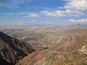 Cordillera de los Frailes, looking west. Pari Chata is on the right in the background, left of it is the Pillku Mayu valley. | |
| Highest point | |
| Elevation | 4,717 m (15,476 ft) [1] |
| Coordinates | 19°19′00″S 66°00′38″W / 19.31667°S 66.01056°WCoordinates: 19°19′00″S 66°00′38″W / 19.31667°S 66.01056°W |
| Geography | |
 Pari Chata Location in Bolivia | |
| Location | Bolivia, Potosí Department, Tomás Frías Province |
| Parent range | Andes |
Pari Chata (Aymara pari red hot,[2] Pukina chata mountain,[3] "red hot mountain", also spelled Parichata) is a 4,717-metre-high (15,476 ft) mountain in the Andes in Bolivia. It is located in the Cordillera de los Frailes in the Potosí Department, Tomás Frías Province, Yocalla Municipality, north of the river Pillku Mayu[4] ("red river").
See also
References
Capital: Potosí | ||
| Provinces | 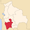 | |
| Municipalities (and seats) |
| |
This article is issued from Wikipedia - version of the 4/29/2016. The text is available under the Creative Commons Attribution/Share Alike but additional terms may apply for the media files.