Parbat District
| Parbat पर्वत | |
|---|---|
| District | |
 kusma | |
| Country | Nepal |
| Region | Western (Pashchimanchal) |
| Zone | Dhaulagiri (धौलागिरी) |
| Area | |
| • Total | 494 km2 (191 sq mi) |
| Population (2001 Main city=kusma,ghayadi,Phalewas,khurga,lunkhu,bayadi,etc..) | |
| • Total | 157,826 |
| • Density | 320/km2 (830/sq mi) |
| Time zone | NPT (UTC+5:45) |
| Website |
www |
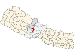
Parbat District (Nepali: पर्वत जिल्ला![]() Listen , is a hilly area of Nepal. It is a part of Province No. 4 and one of the seventy-five districts of Nepal, a landlocked country of South Asia. The district, with Kusma as its district headquarters, covers an area of 494 km² and has a population (2001) of 157,826. It is the fourth smallest district of Nepal with 47 VDCs currently (before Kushma Municipality was formed, total VDCs remained 55.). It is mainly famous for the Gupteshwar Cave, which is visited by thousands of pilgrims during Shivaratri. Patheshwari Temple is the most famous temple of Kushma located at Katuwa Chaupari of Kushma-13. Patheshwori Mandir has lots of sub-temples inside like Ram Janaki Mandir, Bhagwati, Devi, Hanuman, and others. Alapeshwar cave is also the famous cave of this district. It is also noted for the Dahere Deurali Temple, which is visited by thousands of pilgrims during Balachaturdanshai.The bridge in the high place also lies in this district.Recently the modi hydro project of 10 M.W. has been constructed. Here is many popular places such as Dhairing.
From dhairing you can see view of most of mountain of this side.Parbat is a tourism . Parbat's biggest playground is lies in Phalewas village named majhi chour and Indra chour .
Listen , is a hilly area of Nepal. It is a part of Province No. 4 and one of the seventy-five districts of Nepal, a landlocked country of South Asia. The district, with Kusma as its district headquarters, covers an area of 494 km² and has a population (2001) of 157,826. It is the fourth smallest district of Nepal with 47 VDCs currently (before Kushma Municipality was formed, total VDCs remained 55.). It is mainly famous for the Gupteshwar Cave, which is visited by thousands of pilgrims during Shivaratri. Patheshwari Temple is the most famous temple of Kushma located at Katuwa Chaupari of Kushma-13. Patheshwori Mandir has lots of sub-temples inside like Ram Janaki Mandir, Bhagwati, Devi, Hanuman, and others. Alapeshwar cave is also the famous cave of this district. It is also noted for the Dahere Deurali Temple, which is visited by thousands of pilgrims during Balachaturdanshai.The bridge in the high place also lies in this district.Recently the modi hydro project of 10 M.W. has been constructed. Here is many popular places such as Dhairing.
From dhairing you can see view of most of mountain of this side.Parbat is a tourism . Parbat's biggest playground is lies in Phalewas village named majhi chour and Indra chour .
Geography and Climate
Parbat district is a beautiful district with diversified geographical features. It extends from 280 00’ 19” N to 280 23’ 59” N latitude and 830 33’ 40” E to 830 49’ 30” E longitude
| Climate Zone[1] | Elevation Range | % of Area |
|---|---|---|
| Upper Tropical | 300 to 1,000 meters 1,000 to 3,300 ft. |
17.8% |
| Subtropical | 1,000 to 2,000 meters 3,300 to 6,600 ft. |
66.9% |
| Temperate | 2,000 to 3,000 meters 6,400 to 9,800 ft. |
14.0% |
| Subalpine | 3,000 to 4,000 meters 9,800 to 13,100 ft. |
1.4% |
Village development committees (VDCs) and municipalities
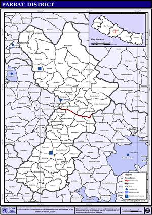
- Arthar Dadakharka
- Bachchha
- Bahaki Thanti
- Bajung
- Balakot
- Banau
- Baskharka
- Behulibas
- Bhangara
- Bhoksing
- Bhorle
- Bhuk Deurali
- Bhuktangle
- Bihadi Barachaur
- Bihadi Ranipani
- Pipaltari
- Chitre
- Chuwa
- Deupurkot
- Deurali
- Devisthan
- Dhairing
- Durlung
- Hosrangdi
- Huwas
- Karkineta
- Katuwa Chaupari
- Khola Lakuri
- Khurkot
- Kurgha
- Kushma Municipality
- Kyang
- Lekhphant
- Limithana
- Lunkhu Deurali
- Mallaj Majhphant
- Mudikuwa
- Nagliwang
- Pakhapani
- Pakuwa
- Pang
- Pangrang
- Phalamkhani
- Phalebas Devisthan
- Phalebas Khanigaun
- Ramja Deurali
- Saligram
- Salija
- Saraukhola
- Shankar Pokhari
- Shivalaya
- Taklak
- Tanglekot
- Thana Maulo
- Thapathana
- Thuli Pokhari
- Tilahar
- Tribeni
- Urampokhara
- Wahakithanti
See also
- Zones of Nepal
- www.kushmaparbat.com(first web site about parbat kushma & parbateli)
- parbatdistrict.blogspot.com(Complete Information about Parbat District.)
- parbatjilla.com
References
- ↑ The Map of Potential Vegetation of Nepal - a forestry/agroecological/biodiversity classification system (PDF), . Forest & Landscape Development and Environment Series 2-2005 and CFC-TIS Document Series No.110., 2005, ISBN 87-7903-210-9, retrieved Nov 22, 2013 horizontal tab character in
|series=at position 91 (help)
- "Districts of Nepal". Statoids.

Coordinates: 28°14′0″N 83°31′0″E / 28.23333°N 83.51667°E
| Wikimedia Commons has media related to Parbat District. |