Paradise Hill, Oklahoma
| Paradise Hill, Oklahoma | |
|---|---|
| Town | |
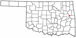 Location of Paradise Hill, Oklahoma | |
| Coordinates: 35°37′26″N 95°4′14″W / 35.62389°N 95.07056°WCoordinates: 35°37′26″N 95°4′14″W / 35.62389°N 95.07056°W | |
| Country | United States |
| State | Oklahoma |
| County | Sequoyah |
| Area | |
| • Total | 0.5 sq mi (1.4 km2) |
| • Land | 0.5 sq mi (1.4 km2) |
| • Water | 0.0 sq mi (0.0 km2) |
| Elevation | 846 ft (258 m) |
| Population (2000) | |
| • Total | 100 |
| • Density | 191.6/sq mi (74.0/km2) |
| Time zone | Central (CST) (UTC-6) |
| • Summer (DST) | CDT (UTC-5) |
| FIPS code | 40-57150[1] |
| GNIS feature ID | 1096427[2] |
Paradise Hill is a town in the northwest corner of Sequoyah County, Oklahoma, United States. It is part of the Fort Smith, Arkansas-Oklahoma Metropolitan Statistical Area. The population was 85 at the 2010 census, a decline from 100 at the 2000 census.[3]
History
Paradise Hill is a relatively new town, having originated in 1954 on the shore of Template:Tenkiller Ferry Lake. There were 47 permanent homes by 1962. The town had already incorporated and owned its own water system. It more than doubled its physical size by 1969 by annexing adjacent land.[3]
Geography
Paradise Hill is located at 35°37′26″N 95°4′14″W / 35.62389°N 95.07056°W (35.624009, -95.070563).[4]
According to the United States Census Bureau, the town has a total area of 0.5 square miles (1.3 km2), of which, 0.5 square miles (1.3 km2) of it is land and 1.89% is water.
Demographics
| Historical population | |||
|---|---|---|---|
| Census | Pop. | %± | |
| 1970 | 87 | — | |
| 1980 | 154 | 77.0% | |
| 1990 | 88 | −42.9% | |
| 2000 | 100 | 13.6% | |
| 2010 | 85 | −15.0% | |
| Est. 2015 | 82 | [5] | −3.5% |
As of the census[1] of 2000, there were 100 people, 45 households, and 31 families residing in the town. The population density was 191.6 people per square mile (74.3/km²). There were 105 housing units at an average density of 201.2 per square mile (78.0/km²). The racial makeup of the town was 76.00% White, 6.00% Native American, 1.00% from other races, and 17.00% from two or more races. Hispanic or Latino of any race were 4.00% of the population.
There were 45 households out of which 22.2% had children under the age of 18 living with them, 64.4% were married couples living together, 4.4% had a female householder with no husband present, and 31.1% were non-families. 28.9% of all households were made up of individuals and 11.1% had someone living alone who was 65 years of age or older. The average household size was 2.22 and the average family size was 2.74.
In the town the population was spread out with 17.0% under the age of 18, 5.0% from 18 to 24, 22.0% from 25 to 44, 27.0% from 45 to 64, and 29.0% who were 65 years of age or older. The median age was 48 years. For every 100 females there were 78.6 males. For every 100 females age 18 and over, there were 80.4 males.
The median income for a household in the town was $30,500, and the median income for a family was $38,125. Males had a median income of $43,333 versus $48,750 for females. The per capita income for the town was $22,835. There were 8.0% of families and 12.4% of the population living below the poverty line, including no under eighteens and 7.4% of those over 64.
References
- 1 2 "American FactFinder". United States Census Bureau. Retrieved 2008-01-31.
- ↑ "US Board on Geographic Names". United States Geological Survey. 2007-10-25. Retrieved 2008-01-31.
- 1 2 Larry O'Dell, "Paradise Hill," Encyclopedia of Oklahoma History and Culture. Accessed March 18, 2015.
- ↑ "US Gazetteer files: 2010, 2000, and 1990". United States Census Bureau. 2011-02-12. Retrieved 2011-04-23.
- ↑ "Annual Estimates of the Resident Population for Incorporated Places: April 1, 2010 to July 1, 2015". Retrieved July 2, 2016.
- ↑ "Census of Population and Housing". Census.gov. Retrieved June 4, 2015.
Municipalities and communities of Sequoyah County, Oklahoma, United States | ||
|---|---|---|
| City | 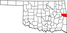 | |
| Towns | ||
| CDPs |
| |
| Unincorporated communities |
| |