Papa Stronsay
| Norse name | Papey Minni/Papey In Litla |
|---|---|
| Meaning of name | Island of the papar near Stronsay |
 Papa Stronsay from the air. The monastery can be seen at the top right. | |
| Location | |
 Papa Stronsay Papa Stronsay shown within Orkney | |
| OS grid reference | HY666293 |
| Physical geography | |
| Island group | Orkney |
| Area | 74 hectares (0.29 sq mi) |
| Area rank | 169 [1] |
| Highest elevation | 13 metres (43 ft) |
| Administration | |
| Sovereign state | United Kingdom |
| Country | Scotland |
| Council area | Orkney Islands |
| Demographics | |
| Population | 0 |
| References | [4][5] |
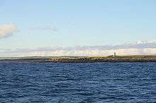 The Light on Papa Stronsay. | |
|
orkney | |
| Location |
Papa Stronsay Orkney Scotland United Kingdom |
|---|---|
| Coordinates | 59°09′21″N 2°34′54″W / 59.155837°N 2.581717°W |
| Year first constructed | 1907 (first) |
| Year first lit | 2002 (current) |
| Automated | 2002 |
| Deactivated | 2002 (first) |
| Foundation | reinforced concrete |
| Construction | metal skeletal tower |
| Tower shape | square parallelepiped tower covered by aluminium panels with balcony and light on the top |
| Markings / pattern | white tower |
| Height | 5 metres (16 ft) |
| Focal height | 8 metres (26 ft) |
| Light source | solar power |
| Characteristic | Iso W 4s. |
| Admiralty number | A3706 |
| NGA number | 3268 |
| ARLHS number | SCO-167 |
| Managing agent | Northern Lighthouse Board[6] |
Papa Stronsay (Old Norse: Papey Minni) is a small island in Orkney, Scotland, lying north east of Stronsay. It is 74 hectares (0.29 sq mi) in size, and 13 metres (43 ft) at its highest point.
According to folklore, some of the natives were descended from a female selkie. This was because they had horny skin on their feet and hands, and permanently smelt of fish.[2]
Geography and geology
The geology is middle old red sandstone.[2]
A thin tongue of land curls west from the main part of the island, and then south to form the Point of the Graand (a local word meaning a "sandbar"). The island in general is low lying, reaching a mere 13 metres (43 ft) at its highest point.
There is an 8 metres (26 ft) high light beacon in the north east.
History
The island has remains of two chapels. One dates from the eleventh century, and an eighth-century Pictish monastery may lie under it. It has been described as the most northerly early Christian monastery ever found.[7] Other remains include cairns and a Burnt mound, and a number of abandoned crofts.
The island is one of the "Papey"s or "islands of the papar. Joseph Anderson noted that:
- "The two Papeys, the great and the little (anciently Papey Meiri and Papey Minni), [are] now Papa Westray and Papa Stronsay... Fordun in his enumeration of the islands, has a 'Papeay tertia' [third Papey], which is not now known. There are three islands in Shetland called Papey, and both in Orkney and in Shetland, there are several districts named Paplay or Papplay, doubtless the same as Papyli of Iceland"[4]
The Orkneyinga saga recalls in Chapter XXXIV that Earl Rögnvald was killed on Papa Stronsay in 1046:
- "Earl Rögnvald resided in Kirkjuvág (Kirkwall) and brought there all necessaries for the winter; he had a great number of men, and much good cheer. A little before Yule (Christmas), earl Rognvald fared with a great following into the Little Papey (Papa Stronsay) to fetch malt, to be brewed for Yule. And at even, as they were on the isle, they sate long over a roasting fire, and he who made up the fire spoke and said that the firewood began to fall short. Then the earl made a slip of the tongue, and these were the words he spoke: “Then are we full old when these fires are burnt out.” But he meant so to have spoken, that they would then be full warmed. And as soon as ever he found it out, he said “I have not made a slip of the tongue before this so that I call it to mind; it comes into my mind what king Olaf my foster-father said at Sticklestead when I took him up for a slip of the tongue: If it ever happens that I made a slip of the tongue I might make up my mind that I should then have but a short time unlived. May be that my kinsman Thorfinn is yet alive.” And just then they heard how that the homestead was girt round by men. There was come earl Thorfinn. They bore fire at once to the house, and laid up a pile of fuel before the doors. They allowed all to go out save the earl’s men. And when most of the men were drawn out, a man went out into the doorway in linen underclothes, and begged earl Thorfinn to stretch out his hand toward the deacon. But that man rested his hands on the balk of wood across the doorway, and vaulted out over the balk and the ring of men, so that he came down ever so far off all of them, and was lost in the darkness of night. Thorfinn bade them hold on after him, and says there went earl Rognvald, “this is his nimbleness, and no one’s else.” Then they fared to hunt for him, and parted themselves into companies, and Thorkell fosterer went along the sea-shore to search. They heard how a dog barked among the rocks on the seashore. Earl Rognvald had his lap dog with him, and he betrayed the earl. They put him to death at once among the rocks, and it is the story of some men that Thorkell fosterer slew him, because there were no other men who would do it."
Everyone agrees that of all the Earls of Orkney Rögnvald Brusason was the most popular and gifted, and his death was mourned by many (Orkneyinga saga Ch. XXIX).
Earl's Knowle on Papa Stronsay is traditionally thought to be the final resting place of Sir Patrick Spens. The history relating to the burial of Sir Patrick Spens on Earl’s Knowle on Papa Stronsay is related by William Edmonstoune Aytoun (b. Edinburgh 21 June 1813, d. 4 August 1865). He was made Sheriff and Lord Admiral of Orkney and Shetland in 1852. It was after his retirement from this position that he edited a collection of Scottish poetry in which the first poem is Sir Patrick Spens. In his forward to the poem Aytoun wrote:
- "“It is true that the name of Sir Patrick Spens is not mentioned in history; but I am able to state that tradition has preserved it. In the little island of Papa Stronsay, one of the Orcadian group, lying over against Norway, there is a large grave or tumulus, which has been known to the inhabitants, from time immemorial, as ‘The grave of Sir Patrick Spens’. The Scottish ballads were not early current in Orkney, a Scandinavian country; so it is very unlikely that the poem could have originated the name. The people know nothing beyond the traditional appellation of the spot, and they have no legend to tell. Spens is a Scottish, not a Scandinavian name. Is it, then, a forced conjecture, that the shipwreck took place off the iron bound coast of the northern islands, which did not then belong to the Crown of Scotland? ‘Half ower to Aberdour’ signifies nothing more than that the vessel went down half-way between Norway and the port of embarkation.”[8]
A fertile island, it became an important centre for herring curing in the eighteenth century, but was abandoned in the 1970s.
Present day

In 1999, the island was purchased from farmer Charles Ronald Smith by the monastic community of the Sons of the Most Holy Redeemer. The traditionalist Catholic religious congregation was formerly affiliated with the Society of St. Pius X. In 2008 the congregation, along with most of its members, was received into full communion with the Holy See. The Golgotha Monastery, is the base for 25 monks, from novices to priests, who hail from as far afield as Australia, Samoa, South Africa and Poland. The monastery has expanded to include a working farm. The ancient monastic ruins dating back to the 7th and 8th centuries mark Papa Stronsay as a holy island and the intention is to rebuild them to their former splendour. The ruins inspire the members of the community to continue the traditions of the Catholic Church and the Redemptorist Congregation from which the community takes its charism.
In 2001 the island had a recorded population of 10[9] although by 2011 there were no "usual residents" living there as recorded by the census.[10]
See also
- List of lighthouses in Scotland
- List of Northern Lighthouse Board lighthouses
- Papa, Scotland, a list of islands named after the papar.
References
- ↑ Area and population ranks: there are c. 300 islands over 20 ha in extent and 93 permanently inhabited islands were listed in the 2011 census.
- 1 2 3 Haswell-Smith, Hamish (2004). The Scottish Islands. Edinburgh: Canongate. ISBN 978-1-84195-454-7.
- ↑ Ordnance Survey: Landranger map sheet 5 Orkney (Northern Isles) (Map). Ordnance Survey. 2008. ISBN 9780319228111.
- 1 2 Anderson, Joseph (Ed.) (1893) Orkneyinga Saga. Translated by Jón A. Hjaltalin & Gilbert Goudie. Edinburgh. James Thin and Mercat Press (1990 reprint). ISBN 0-901824-25-9
- ↑ Pedersen, Roy (January 1992) Orkneyjar ok Katanes (map, Inverness, Nevis Print)
- ↑ Papa Stronsay The Lighthouse Directory. University of North Carolina at Chapel Hill. Retrieved 27 May 2016
- ↑ http://www.independent.co.uk/news/uk/this-britain/early-christian-outpost-found-in-remote-orkneys-710872.html
- ↑ http://www.papastronsay.com/island/index.html
- ↑ General Register Office for Scotland (28 November 2003) Scotland's Census 2001 – Occasional Paper No 10: Statistics for Inhabited Islands. Retrieved 26 February 2012.
- ↑ National Records of Scotland (15 August 2013) (pdf) Statistical Bulletin: 2011 Census: First Results on Population and Household Estimates for Scotland - Release 1C (Part Two). "Appendix 2: Population and households on Scotland’s inhabited islands". Retrieved 17 August 2013.
External links
- Death of Rognvald
- Golgotha monastery
- Youtube documentary on Golgotha monastery.
- Northern Lighthouse Board
Coordinates: 59°09′N 2°35′W / 59.150°N 2.583°W