Panicale
| Panicale | |
|---|---|
| Comune | |
| Comune di Panicale | |
|
Backside of the Church of San Michele Archangelo on Piazza Umberto I, the main square of Panicale | |
.svg.png) Position of Panicale within the Province of Perugia | |
 Panicale Location of Panicale in Italy | |
| Coordinates: 43°2′N 12°6′E / 43.033°N 12.100°ECoordinates: 43°2′N 12°6′E / 43.033°N 12.100°E | |
| Country | Italy |
| Region | Umbria |
| Province / Metropolitan city | Province of Perugia (PG) |
| Frazioni | Tavernelle, Colle San Paolo, Missiano, Casalini, Colle Calzolaro, Macereto, Mongiovino, Montale, Colgiordano, Gioveto, Migliaiolo |
| Government | |
| • Mayor | Giulio Cherubini (Partito Democratico) |
| Area | |
| • Total | 78.8 km2 (30.4 sq mi) |
| Elevation | 441 m (1,447 ft) |
| Population (Dec. 2012)[1] | |
| • Total | 5,669 |
| • Density | 72/km2 (190/sq mi) |
| Demonym(s) | Panicalesi |
| Time zone | CET (UTC+1) |
| • Summer (DST) | CEST (UTC+2) |
| Postal code | 06064, 06068 |
| Dialing code | 075 |
| Patron saint | Michael |
| Saint day | September 29 |
| Website | Official website |

Panicale is a comune (municipality) in the Province of Perugia in the Italian region Umbria. Located on the eastern slope of Mount Petrarvella, in the southeast of Valdichiana, it overlooks Lake Trasimeno and it is about 35 km far from Perugia.
As of 31 December 2012, it had a population of 5,669 and an area of 78.8 km².
The municipality of Panicale contains the frazioni (subdivisions, mainly villages and hamlets) Tavernelle, Colle San Paolo, Missiano, Casalini, Colle Calzolaro, Macereto, Mongiovino, Montale, Colgiordano, Gioveto and Migliaiolo.
Panicale borders the following municipalities: Castiglione del Lago, Magione, Paciano, Perugia and Piegaro.
Main sights
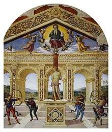
Pietro Perugino's Martyrdom of Saint Sebastian
- Church of Saint Sebastian, contains Pietro Perugino's Fresco Martyrdom of Saint Sebastian (1505)
Demographic evolution

References
External links
| Wikimedia Commons has media related to Panicale. |
This article is issued from Wikipedia - version of the 10/23/2016. The text is available under the Creative Commons Attribution/Share Alike but additional terms may apply for the media files.