Pangantucan, Bukidnon
| Pangantucan | ||
|---|---|---|
| Municipality | ||
| ||
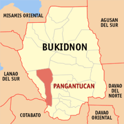 Map of Philippines with Pangantucan highlighted | ||
.svg.png) Pangantucan Location within the Philippines | ||
| Coordinates: 7°50′N 124°50′E / 7.83°N 124.83°ECoordinates: 7°50′N 124°50′E / 7.83°N 124.83°E | ||
| Country | Philippines | |
| Region | Northern Mindanao (Region X) | |
| Province | Bukidnon | |
| District | 4th district of Bukidnon | |
| Founded | July 1, 1962 | |
| Barangays | 19 | |
| Government[1] | ||
| • Mayor | Miguel Silva, Jr. | |
| Area[2] | ||
| • Total | 461.72 km2 (178.27 sq mi) | |
| Population (2015 census)[3] | ||
| • Total | 53,126 | |
| • Density | 120/km2 (300/sq mi) | |
| Time zone | PST (UTC+8) | |
| ZIP code | 8717 | |
| IDD : area code | +63 (0)88 | |
| Income class | 1st | |
| Website |
www | |
Pangantucan is a first class municipality in the province of Bukidnon, Philippines. According to the 2015 census, it has a population of 53,126 people.[3]
Geography

Pangantucan is one of 20 municipalities in the Province of Bukidnon. It is situated at the south–western part of the province of Bukidnon and located approximately 75 kilometres (47 mi) south of Malaybalay, the capital town of Bukidnon, and is about 166 kilometres (103 mi) away from Cagayan de Oro City. Wao, Lanao del Sur, can be reached through a 50 kilometres (31 mi) concrete/gravel paved national road south from the municipality.
The Municipality of Pangantucan is bounded on the south-west side by the province of Lanao del Sur and by the province of North Cotabato on the southern part. The Municipality of Kalilangan lies at the western part of the municipality while on its north-west portion is the Mount Kitanglad Range. Valencia, regarded as the trade center of Bukidnon bounds Pangantucan on its northern part while Maramag and the Municipalities of Don Carlos and Kadingilan are found on its east and south side respectively.
Pangantucan has a land area of 46,172 hectares (114,090 acres) which is 9th largest among the 20 municipalities and two cities of the province. It composed of 19 barangays, all of which are accessible on summer days by motor vehicle fit for the bad roads.
Topography
The terrain of Pangantucan is characterized by slightly undulating and rolling upland areas. In fact, 62 percent of the municipal land area features rolling or hilly terrain with slopes ranging from 18 percent to 50 percent. Only about 14 percent is suitable for agricultural production. On the north-west portion of the municipality is Mount Kalatungan, the second highest peak in the province with an elevation of 2,824 metres (9,265 ft). Its ranges occupy about 21 percent of the municipality’s total land area.
Climate
The climate of Pangantucan is of Type IV of the Modified Corona’s Climate Classification. It is characterized by more or less evenly distributed rainfall throughout the year with rare incidence of tropical cyclone. Rainfall distribution variation (Figure 1) is influenced by rain shadow effect of the mountainous belt on the eastern side of Bukidnon and by the presence of adjoining hills and mountain ranges.
Based on the data from 1995–2000, Pangantucan has an annual average rainfall of 2,764.60 millimetres (108.843 in). June is the wettest month with an average rainfall of 354.14 millimetres (13.943 in), followed by the months of August, September and July with an average rainfall of 341.21 millimetres (13.433 in), 311.33 millimetres (12.257 in), and 296.28 millimetres (11.665 in) respectively. February is the driest month with its average rainfall of 108.17 millimetres (4.259 in). Note that abnormally low values during the time from December 1997 to May 1998 coincided with drought months.
Barangays
Pangantucan is politically subdivided into 19 barangays.[2]
- Adtuyon
- Bacusanon
- Bangahan
- Barandias
- Concepcion
- Gandingan
- Kimanait
- Kipadukan
- Langcataon
- Lantay
- Madaya
- Malipayon
- Mendis
- Nabaliwa
- New Eden
- Payad
- Pigtauranan
- Poblacion
- Portulin
History
The name “Pangantucan”, meaning wisdom and strength, is dedicated to a white stallion. The horse uprooted a bamboo stalk in time to warn his master, a datu of the tribe, of the impending threat of Manobo raiders, thereby saving the tribe from massacre.
Pangantucan was once a barrio of Maramag, and as the seat of government it was merged in 1931 with neighbouring Adtuyon, Dominorog, Panalagsagan, Kalilangan and Barandias to form a separate municipal district. It was granted Municipal status in 1961.
Demographics
| Population census of Pangantucan | ||
|---|---|---|
| Year | Pop. | ±% p.a. |
| 1990 | 35,777 | — |
| 1995 | 38,418 | +1.34% |
| 2000 | 43,202 | +2.55% |
| 2007 | 46,689 | +1.08% |
| 2010 | 48,775 | +1.60% |
| 2015 | 53,126 | +1.64% |
| Source: Philippine Statistics Authority[3][4] | ||
In the 2015 census, the population of Pangantucan was 53,126 people,[3] with a density of 120 inhabitants per square kilometre or 310 inhabitants per square mile.
In the 2010 census, the population of Pangantucan stood at 48,775 people, up from 46,689 in 2007. Its density was 205 persons per square kilometer. It registered a population growth of 1.64 percent based on the 1990-2007 census of population. Available data indicated that the population has steadily been increasing from 1976 up to the present. Of the total population 51.45% are male and the rest are the female population.
Economy
The Poblacion is the nucleus of growth within the municipality. It is the center of both government and commercial activities, and the site of various establishments, services and facilities.
Outside the Poblacion are the rural areas where majority of the population reside, and whose prime economic activity is farming. Agriculture is the major land user with an aggregate are of 17,429 hectares devoted to its use. Of this area, 4,806 hectares are planted with corn and 1,121 hectares are planted with rice. Commercial/industrial and other crops account for some 11,502 hectares.
In addition livestock and poultry are also major sources of livelihood in Pangantucan, Total livestock in 2002 reached 20,276. On the other hand, poultry production was reported at 56,710 for the same period.
Supporting the agricultural activities in the municipality are about 74 tractors, 6 rice thresher, 97 corn shellers, 19 rice/corn mills, 6 mechanical dryers, 128 multi-purpose pavement and 5 storage/warehousing facilities.
Commerce and trade play a significant role in Pangantucan economy. Some 232 commercial establishments are reported in the area of which about 4 engaged in wholesale activity. Among such wholesale establishments include 2 branches of the BS Garces Payless Mart chain of stores - a 2 storey-building within the public market-bus terminal area and a 3 storey-building with a mezzanine along the main highway.
References
- ↑ "Official City/Municipal 2013 Election Results". Intramuros, Manila, Philippines: Commission on Elections (COMELEC). 1 July 2013. Retrieved 5 September 2013.
- 1 2 "Province: BUKIDNON". PSGC Interactive. Makati City, Philippines: National Statistical Coordination Board. Retrieved 12 June 2014.
- 1 2 3 4 "Region X (NORTHERN MINDANAO)". Census of Population (2015): Total Population by Province, City, Municipality and Barangay (Report). PSA. Retrieved 20 June 2016.
- ↑ "Region X (NORTHERN MINDANAO)". Census of Population and Housing (2010): Total Population by Province, City, Municipality and Barangay (Report). NSO. Retrieved 29 June 2016.
External links
 |
Talakag | Valencia City | | |
| Kalilangan | |
Maramag Don Carlos | ||
| ||||
| | ||||
| Wao, Lanao del Sur Banisilan, Cotabato |
|
Kadingilan |