Panama City, Florida
| Panama City, Florida | |||
|---|---|---|---|
| City | |||
| City of Panama City | |||
|
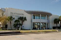
Panama City's city hall in November 2013. | |||
| |||
 Location in Bay County and the U.S. state of Florida | |||
| Coordinates: 30°10′28″N 85°39′52″W / 30.17444°N 85.66444°WCoordinates: 30°10′28″N 85°39′52″W / 30.17444°N 85.66444°W | |||
| Country |
| ||
| State |
| ||
| County |
| ||
| Incorporated | 1909 | ||
| Government | |||
| • Mayor | Greg Brudnicki | ||
| Area | |||
| • City | 35.4 sq mi (91.8 km2) | ||
| • Land | 29.3 sq mi (75.8 km2) | ||
| • Water | 6.2 sq mi (16.0 km2) | ||
| Elevation | 26 ft (8 m) | ||
| Population (2010) | |||
| • City | 36,484 | ||
| • Density | 1,000/sq mi (400/km2) | ||
| • Metro | 168,852 | ||
| Time zone | Central (CST) (UTC-6) | ||
| • Summer (DST) | CDT (UTC-5) | ||
| Zip Codes | 32401–32409, 32411–32413, 32417, 32461 | ||
| Area code(s) | 850 | ||
| FIPS code | 12-54700[1] | ||
| GNIS feature ID | 0288448[2] | ||
| Website | www.pcgov.org | ||


Panama City is a city and the county seat of Bay County, Florida, United States.[3] Located along U.S. Route 98, it is the largest city between Tallahassee and Pensacola. It is the more populated of two principal cities of the Panama City-Lynn Haven, Florida Metropolitan Statistical Area. As of the 2010 census, the city population was 36,484.[4] When Panama City was incorporated in 1909, its original city limits were 15th Street (Hwy 98) on the north, Balboa Avenue on the west and Bay Avenue on the east.
Name
The development of the area of Northwest Florida that was first incorporated as Panama City started as an unincorporated settlement first called "Floriopolis," which became "Park Resort" and then "Harrison" [5] a name still assigned to Panama City's major downtown thoroughfare. According to the Panama City Public Library's A History of Panama City,[6] a developer named George Mortimer West hoped to spur real estate development in Bay County during a period of intense popular interest in the construction of the Panama Canal by changing the town's name from Harrison to Panama City, because a straight line between Chicago and the capital of the Central American country of Panama intersected the Florida town. Additionally, since required meanders around land formations in a seaborne route to the canal added distance when starting at other ports, Panama City was the closest developed port in the US mainland to the Caribbean entrance of the Panama Canal.
Demographics
| Historical population | |||
|---|---|---|---|
| Census | Pop. | %± | |
| 1910 | 422 | — | |
| 1920 | 1,722 | 308.1% | |
| 1930 | 5,402 | 213.7% | |
| 1940 | 11,610 | 114.9% | |
| 1950 | 25,814 | 122.3% | |
| 1960 | 33,275 | 28.9% | |
| 1970 | 32,096 | −3.5% | |
| 1980 | 33,346 | 3.9% | |
| 1990 | 34,378 | 3.1% | |
| 2000 | 36,417 | 5.9% | |
| 2010 | 36,484 | 0.2% | |
| Est. 2015 | 38,286 | [7] | 4.9% |
As of the census[1] of 2010, there were 36,484 people, 14,792 households, and 8,613 families residing in the city. The population density was 1,245.2 people per square mile (481.3/km2). There were 17,438 housing units at an average density of 595.2 per square mile (230.1/km2). As of the census[1] of 2010, the racial makeup of the city is 71.6% White, 22.0% African American, 1.6% Asian, 0.5% Native American, 0.1% Pacific Islander, 2.9% from two or more races, and 5.1% Hispanic or Latino of any race.
There were 14,792 households, out of which 23.6% had children under the age of 18 living with them, 36.3% were headed by married couples living together, 6.8% had a female householder with no husband present, and 41.8% were non-families. 34.1% of all households were made up of individuals, and 13.0% were someone living alone who was 65 years of age or older. The average household size was 2.28, and the average family size was 2.91.[4]
In the city the population was 20.7% under the age of 18, 10.2% from 18 to 24, 25.9% from 25 to 44, 26.9% from 45 to 64, and 16.3% who were 65 years of age or older. The median age was 39.7 years. For every 100 females there were 96.3 males. For every 100 females age 18 and over, there were 95.2 males.[4]
Geography
Panama City is located at 30°10′28″N 85°39′52″W / 30.17444°N 85.66444°W (30.174451, -85.664480)[9] within the Florida Panhandle and along the Emerald Coast. According to the United States Census Bureau, the city limits encompass an area of 35.4 square miles (91.8 km2), of which 29.3 square miles (75.8 km2) is land and 6.2 square miles (16.0 km2), or 17.39%, is water.[10]
Climate
Panama City has a humid subtropical climate, with short, mild winters and long, hot and humid summers. In January, the average low is 42 °F (6 °C), and in July the average high is 90 °F (32 °C).
The city is susceptible to hurricanes, such as Hurricane Earl, which brought winds of more than eighty miles per hour in 1998.
| Climate data for Panama City, Fla. | |||||||||||||
|---|---|---|---|---|---|---|---|---|---|---|---|---|---|
| Month | Jan | Feb | Mar | Apr | May | Jun | Jul | Aug | Sep | Oct | Nov | Dec | Year |
| Average high °F (°C) | 63.3 (17.4) |
66.3 (19.1) |
71.6 (22) |
77.5 (25.3) |
84.4 (29.1) |
88.7 (31.5) |
90.1 (32.3) |
90.0 (32.2) |
88.2 (31.2) |
81.2 (27.3) |
73.0 (22.8) |
65.0 (18.3) |
78.28 (25.71) |
| Average low °F (°C) | 42.1 (5.6) |
46.3 (7.9) |
51.3 (10.7) |
57.4 (14.1) |
65.4 (18.6) |
72.7 (22.6) |
75.1 (23.9) |
74.8 (23.8) |
70.8 (21.6) |
60.4 (15.8) |
51.4 (10.8) |
44.2 (6.8) |
59.33 (15.18) |
| Average precipitation inches (mm) | 4.89 (124.2) |
5.11 (129.8) |
5.68 (144.3) |
3.67 (93.2) |
3.08 (78.2) |
6.18 (157) |
7.39 (187.7) |
6.96 (176.8) |
6.03 (153.2) |
3.60 (91.4) |
4.47 (113.5) |
4.02 (102.1) |
61.1 (1,552) |
| Source: Florida Climate Center[11] | |||||||||||||
Economy
Personal income
As of the 2000 census, the median income for a household in the city was $31,572, and the median income for a family was $40,890. Males had a median income of $30,401 versus $21,431 for females. The per capita income for the city was $17,830. About 12.1% of families and 17.2% of the population were below the poverty line, including 24.5% of those under age 18 and 14.9% of those age 65 or over.
Industry
Although two military bases result in the federal government's being the single largest employer, major industrial employers in the Bay County area include Eastern Shipbuilding Group, Gulf Power, WestRock, Trane, L-3 Communications, ARINC, and JENSEN-GROUP.[12]
Real estate
In 2006, Panama City was named the best place to invest in real estate in the US by CNN's Business 2.0 magazine.[13]
Military
Tyndall Air Force Base is located east of the city. The HHT 1-153 CAV is stationed there. It is part of Florida Army National Guard's 53rd Infantry Brigade. The city is also home to the U.S. Navy's Naval Support Activity Panama City which is home to various research and training projects.
Retail
The main retail center is Panama City Mall as well as Pier Park.
Transportation
Roads
The two main east-to-west thoroughfares in Panama City proper are 23rd Street and U.S. Highway 98. The main north-to-south thoroughfare is Martin Luther King Boulevard, otherwise known as FL-77. :)
Rail
The Bay Line Railroad has an 82-mile (132 km) rail line running north to Dothan, Alabama, to a connection with CSX Transportation and Norfolk Southern.
Bus transportation
Local transit is handled by the Baytown Trolley services.[14] Service generally runs Monday-Saturday from 6 AM to 7 PM.
Intercity transit is handled by the city's Greyhound station.[15]
Air transportation
The city was served by the Panama City-Bay County International Airport (PFN) until May 22, 2010. It was replaced by the Northwest Florida Beaches International Airport (ECP) with Southwest Airlines, Delta Air Lines, United Airlines, and Silver Airways.
Notable people
- Paula Barbieri, former model and actress; ex-girlfriend of O. J. Simpson
- Robert E. "Bob" Barton, former member of the Louisiana House of Representatives, graduated from Bay High School
- Blood Raw, rapper with the group U.S.D.A and Young Jeezy
- Jaye Chapman, pitcher with the Chicago Cubs
- Donnie Craft, American player of gridiron football
- Clint Daniels, country music artist
- Clarence Earl Gideon, the plaintiff in Gideon v. Wainwright
- Herman Goldner, former mayor of St. Petersburg, lived in Panama City from 1991 to 1999
- David Herndon, pitcher with the New York Yankees
- Nathan Macias, Texas politician; former commander of the "Silver Flag", the USAF Civil Engineering Contingency Training Center at Tyndall Air Force Base[16]
- Bill Mazeroski, baseball Hall of Fame member
- Robert Lee McKenzie, entrepreneur, real estate developer, first mayor of Panama City, and an important figure in the early history of Bob Jones University
- Dan Peek, member of the soft rock band America
- Blake Percival, Whistleblower
- Anwar Stewart, defensive lineman, Montreal Alouettes of the Canadian Football League
- Ray Wilson, defensive back in the National Football League for the New Orleans Saints and Green Bay Packers
- William Witherspoon, 1998 graduate of Rutherford High School, linebacker in the National Football League, for the Carolina Panthers, St. Louis Rams,Philadelphia Eagles & Tennessee Titans
Fictional references
- Charles "Trip" Tucker III, (short for "Triple", since he is the third generation of his family to be named Charles Tucker), played by Connor Trinneer, is a fictional character in the television series Star Trek: Enterprise, which is the last generation of the Star Trek series. According to Star Trek lore, "Trip" was born and lived in Panama City. Tucker had a sister who was killed by the Xindi along with 7 million other Humans in the year 2153.
Media
- The News Herald, newspaper
- WFSG, PBS affiliate on channel 56 (satellite of WFSU-TV, Tallahassee)
- WJHG, NBC affiliate on channel 7 (The CW & My Network TV digital)
- WMBB, ABC affiliate on channel 13
- WECP-LD, CBS affiliate on channel 18
- WPGX, Fox affiliate on channel 28
- Panama City Beach TV - Public-access television cable TV[17]
- WASJ, Bob FM 105.1, 1980s/1990s/2000s
- WBPC, Beach 95.1, Oldies
- WDIZ, The Breeze 590 AM, Adult Standards - Easy Listening
- WFLF-FM, Fox News Radio
- WFSW, public radio
- WFSY, adult contemporary
- WILN, Island 106, Contemporary hit radio
- WKGC and WKGC-FM, public radio
- WKNK, Kick'n Country, country
- WPAP, country
- WPFM, Hot 107.9, Contemporary hit radio
- WRBA, Classic Rock 95.9, Classic Rock
- WYOO, Talk Radio 101, Talk Radio
- WVVE, 97X, "Panama City's Rock Station"
- WAYP-FM, 88.3 WAY-FM Christian Hit Radio
Education
Panama City's public schools are operated by Bay District School. A system of charter schools, University Academy and Bay Haven Schools also services the Panama City area. Private schools in the city include, Holy Nativity Episcopal School, Jacob Austin Prep. Academy, Covenant Christian School. Gulf Coast State College, formerly Gulf Coast Community College, is now a 4-year state college. Florida State University Panama City Campus and a satellite campus of Troy University are located in the city. Embry Riddle Aeronautical University has a satellite campus on Tyndall Air Force Base. Public high schools in the Panama City metro-area include Rutherford High School, Bay High School, Mosley High School, Arnold High School, Bozeman Learning Center, and Rowsenwald High School.
References
- 1 2 3 "American FactFinder". United States Census Bureau. Retrieved 2008-01-31.
- ↑ "US Board on Geographic Names". United States Geological Survey. 2007-10-25. Retrieved 2008-01-31.
- ↑ "Find a County". National Association of Counties. Retrieved 2011-06-07.
- 1 2 3 "Profile of General Population and Housing Characteristics: 2010 Demographic Profile Data (DP-1): Panama City city, Florida". U.S. Census Bureau, American Factfinder. Retrieved March 14, 2012.
- ↑ http://www.baycounty100.com/History-Bay-County-FL.aspx
- ↑ Morris, Allen Covington & Joan Perry Morris. Florida Place Names: Alachua to Zolfo Springs, Pineapple Press Inc, 1995, pg. 190.
- ↑ "Annual Estimates of the Resident Population for Incorporated Places: April 1, 2010 to July 1, 2015". Retrieved July 2, 2016.
- ↑ "Census of Population and Housing". Census.gov. Retrieved June 4, 2015.
- ↑ "US Gazetteer files: 2010, 2000, and 1990". United States Census Bureau. 2011-02-12. Retrieved 2011-04-23.
- ↑ "Geographic Identifiers: 2010 Demographic Profile Data (G001): Panama City city, Florida". U.S. Census Bureau, American Factfinder. Retrieved March 14, 2012.
- ↑ "Panama City". Florida Climate Center. Retrieved 2015-02-11.
- ↑ Major Employers
- ↑ CNN.com
- ↑ http://v2.baytowntrolley.org/
- ↑ https://www.greyhound.com/en/locations/terminal.aspx?city=471230
- ↑ "House Membership: Representative Nathan Mathias" (PDF). Texas Legislative Reference Library. Retrieved February 22, 2014.
- ↑ Panama City Beach TV
External links
| Wikimedia Commons has media related to Panama City, Florida. |
| Wikivoyage has a travel guide for Panama City, Florida. |
- Panama City official website
- Panama City Beach Convention and Visitors Bureau
- Panama City, Florida's history with tropical systems from hurricanecity.com
- Historic newspapers for Panama City in the Florida Digital Newspaper Library including the Panama City Pilot
- U.S. Geological Survey Geographic Names Information System: Panama City, Florida
 |
Lynn Haven | | ||
| Panama City Beach | |
Parker | ||
| ||||
| | ||||
| Mexico Beach |
Municipalities and communities of Bay County, Florida, United States | ||
|---|---|---|
| Cities | 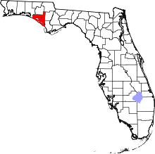 | |
| CDPs | ||
| Unincorporated communities | ||