Palo Alto station
Palo Alto | |||||||||||||||||||||||||||||||||||||||
|---|---|---|---|---|---|---|---|---|---|---|---|---|---|---|---|---|---|---|---|---|---|---|---|---|---|---|---|---|---|---|---|---|---|---|---|---|---|---|---|
| Commuter rail | |||||||||||||||||||||||||||||||||||||||
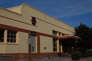 The rear of the station. | |||||||||||||||||||||||||||||||||||||||
| Location |
95 University Avenue Palo Alto, CA 94301 | ||||||||||||||||||||||||||||||||||||||
| Coordinates | 37°26′36″N 122°09′55″W / 37.443442°N 122.165196°WCoordinates: 37°26′36″N 122°09′55″W / 37.443442°N 122.165196°W | ||||||||||||||||||||||||||||||||||||||
| Owned by | Peninsula Corridor Joint Powers Board | ||||||||||||||||||||||||||||||||||||||
| Line(s) |
Local service Limited-stop service | ||||||||||||||||||||||||||||||||||||||
| Platforms | 2 side platforms | ||||||||||||||||||||||||||||||||||||||
| Tracks | 2 | ||||||||||||||||||||||||||||||||||||||
| Connections |
VTA Bus Routes: 22, 35, 522 Dumbarton Express Caltrain Shuttles: Embarcadero & Crosstown Stanford University: Marguerite Shuttle Samtrans ECR, 280, 281, 297, 397 | ||||||||||||||||||||||||||||||||||||||
| Construction | |||||||||||||||||||||||||||||||||||||||
| Parking | Available | ||||||||||||||||||||||||||||||||||||||
| Bicycle facilities | Racks available | ||||||||||||||||||||||||||||||||||||||
| Disabled access | Yes | ||||||||||||||||||||||||||||||||||||||
| Other information | |||||||||||||||||||||||||||||||||||||||
| Fare zone | 3 | ||||||||||||||||||||||||||||||||||||||
| History | |||||||||||||||||||||||||||||||||||||||
| Opened | October 1940 | ||||||||||||||||||||||||||||||||||||||
| Traffic | |||||||||||||||||||||||||||||||||||||||
| Passengers (2014) |
6,156 per weekday[1] | ||||||||||||||||||||||||||||||||||||||
| Services | |||||||||||||||||||||||||||||||||||||||
| |||||||||||||||||||||||||||||||||||||||
|
Palo Alto Southern Pacific Railroad Depot | |||||||||||||||||||||||||||||||||||||||
  | |||||||||||||||||||||||||||||||||||||||
| Location | Palo Alto, California | ||||||||||||||||||||||||||||||||||||||
| Coordinates | 37°26′34.82″N 122°9′53.56″W / 37.4430056°N 122.1648778°W | ||||||||||||||||||||||||||||||||||||||
| Built | 1931 | ||||||||||||||||||||||||||||||||||||||
| Architect | John H. Christie | ||||||||||||||||||||||||||||||||||||||
| Architectural style | Streamline Moderne | ||||||||||||||||||||||||||||||||||||||
| NRHP Reference # | 96000425[2] | ||||||||||||||||||||||||||||||||||||||
| Added to NRHP | April 18, 1996 | ||||||||||||||||||||||||||||||||||||||
Palo Alto is the main train station in Palo Alto, California and the second busiest in the Caltrain system after the 4th and King Street Station in downtown San Francisco.[3] It is a regional transit center where passengers can take buses serving Santa Clara County (VTA), San Mateo County (SamTrans) and Stanford University (Marguerite Shuttle), as well as Caltrain commuters; in addition the Dumbarton Express bus administered by AC Transit takes passengers back and forth over the Dumbarton Bridge to Union City BART station in the East Bay. It is listed on the National Register of Historic Places for its architectural significance.
Location
The station building is across the tracks from Alma Street, with a car entrance to the parking lot at Alma Street and Lytton Avenue. Daily parking is $5. It is on the west side of Downtown Palo Alto and offers easy access to the downtown Palo Alto Area and the Stanford University campus. It is one of two stations in Palo Alto; the other is farther south at Alma and California Avenue. On December 11, 2009, Cafe Venetia opened inside the historic Palo Alto train station.
Architecture
The station is in the Streamline Moderne style which has connections with American history and is not typically found in Palo Alto. During the 1920s and 1930s most significant buildings in town were designed by a local architect, Birge Clark, who usually worked in the Mission Revival or Spanish Colonial Revival styles. The other major buildings of that era, such as large commercial blocks and apartment buildings, the main Post Office, the Community Center and other civic buildings were Mission Revival or Spanish Colonial Revival styles.[4]
On October 22, 1940 the cornerstone was laid for the new railroad station designed by J.H. Christie, a full-time architect employed by the Southern Pacific Railroad. It replaced an 1897 station; it was part of the grade separation project that moved the tracks a few feet southwest from the straight line that had extended south from Redwood City. The building is 215 feet (65 m) long by 25 feet (7.6 m) wide with an arcade in front and a marquee at the rear including two buildings connected by an arcade. The interior has a ticket office, waiting room, rest rooms, baggage room and a passageway between the waiting room and baggage room.[4] The interior is not open to the public now; tickets are purchased from machines on the platform.
The interior has a mural by John McQuarrie depicting Leland Stanford's dream of a University influenced by a pageant of transportation. It shows facts and events in the development of California. This one-story streamlined Southern Pacific station personifies the tendency of the 1930s to style buildings like transportation machinery, in this case the Streamline train. The building has all the trademarks: porthole windows, horizontal parallel lines to indicate speed and glass blocks.[4]
The station was refurbished in the 1980s.
Platforms and tracks
| Northbound | ■ Local service | toward San Francisco (Menlo Park) |
| ■ Limited-stop service | toward San Francisco (Menlo Park or San Carlos) | |
| ■ Baby Bullet, Pattern A | toward San Francisco (Hillsdale) | |
| ■ Baby Bullet, Peak Pattern B | toward San Francisco (Redwood City) | |
| ■ Baby Bullet, Reverse Peak Pattern B | toward San Francisco (Menlo Park) | |
| Southbound | ■ Local service | toward Gilroy (Stanford or California Ave) |
| ■ Limited-stop service | toward Tamien, Gilroy during peak hours (California Ave) | |
| ■ Baby Bullet | toward San Jose Diridon (Mountain View) | |
| ■ Baby Bullet, Peak Pattern B | toward Tamien (Sunnyvale) |
Bike station
Due to the high number of bicyclists in Palo Alto, a bike station has been built inside the old Southern Pacific baggage room. There is now a small fee to leave a bike there, and the area is no longer supervised. Use of these facilities requires sign-up.
Station amenities
- Caltrain ticket machines
- Clipper Add-Value machine
- Coffee Shop (Cafe Venetia)
References
- ↑ Caltrain. "February 2014 Caltrain Annual Passenger Counts" (PDF). Retrieved 2014-07-11.
- ↑ National Park Service (2006-03-15). "National Register Information System". National Register of Historic Places. National Park Service.
- ↑ "Palo Alto Stations Improvement Project". Retrieved 4 June 2011.
- 1 2 3 "Palo Alto Southern Pacific Railroad Depot". California's Historic Silicon Valley. National Park Service. Retrieved 2008-01-18.
External links
 Media related to Southern Pacific Railroad depot, Palo Alto, California at Wikimedia Commons
- The train depot at Palo Alto History.com
- Caltrain Palo Alto station page
| Stations |
| |
|---|---|---|
| Connecting Services | ||
| Management | ||
| History | ||
| Miscellaneous | ||

![]() This article incorporates public domain material from websites or documents of the National Park Service.
This article incorporates public domain material from websites or documents of the National Park Service.