Palmer, Kansas
| Palmer, Kansas | |
|---|---|
| City | |
 Location within Washington County and Kansas | |
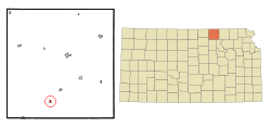
 KDOT map of Washington County (legend) | |
| Coordinates: 39°37′58″N 97°8′24″W / 39.63278°N 97.14000°WCoordinates: 39°37′58″N 97°8′24″W / 39.63278°N 97.14000°W | |
| Country | United States |
| State | Kansas |
| County | Washington |
| Area[1] | |
| • Total | 0.31 sq mi (0.80 km2) |
| • Land | 0.31 sq mi (0.80 km2) |
| • Water | 0 sq mi (0 km2) |
| Elevation | 1,329 ft (405 m) |
| Population (2010)[2] | |
| • Total | 111 |
| • Estimate (2012[3]) | 110 |
| • Density | 360/sq mi (140/km2) |
| Time zone | Central (CST) (UTC-6) |
| • Summer (DST) | CDT (UTC-5) |
| ZIP code | 66962 |
| Area code | 785 |
| FIPS code | 20-54200 [4] |
| GNIS feature ID | 0484342 [5] |
Palmer is a city in Washington County, Kansas, United States. As of the 2010 census, the city population was 111.[6]
History
Palmer was founded in 1878.[7] It was named for J. Palmer, a teacher.[8]
The first post office in Palmer was established in June 1878.[9]
Geography
Palmer is located at 39°37′58″N 97°8′24″W / 39.63278°N 97.14000°W (39.632737, -97.140028).[10] According to the United States Census Bureau, the city has a total area of 0.31 square miles (0.80 km2), all of it land.[1]
Demographics
| Historical population | |||
|---|---|---|---|
| Census | Pop. | %± | |
| 1880 | 125 | — | |
| 1890 | 203 | 62.4% | |
| 1920 | 179 | — | |
| 1930 | 187 | 4.5% | |
| 1940 | 182 | −2.7% | |
| 1950 | 150 | −17.6% | |
| 1960 | 169 | 12.7% | |
| 1970 | 166 | −1.8% | |
| 1980 | 149 | −10.2% | |
| 1990 | 121 | −18.8% | |
| 2000 | 108 | −10.7% | |
| 2010 | 111 | 2.8% | |
| Est. 2015 | 107 | [11] | −3.6% |
| U.S. Decennial Census | |||
2010 census
As of the census[2] of 2010, there were 111 people, 50 households, and 34 families residing in the city. The population density was 358.1 inhabitants per square mile (138.3/km2). There were 62 housing units at an average density of 200.0 per square mile (77.2/km2). The racial makeup of the city was 89.2% White and 10.8% from other races. Hispanic or Latino of any race were 13.5% of the population.
There were 50 households of which 24.0% had children under the age of 18 living with them, 64.0% were married couples living together, 2.0% had a female householder with no husband present, 2.0% had a male householder with no wife present, and 32.0% were non-families. 32.0% of all households were made up of individuals and 12% had someone living alone who was 65 years of age or older. The average household size was 2.22 and the average family size was 2.76.
The median age in the city was 50.1 years. 17.1% of residents were under the age of 18; 9.9% were between the ages of 18 and 24; 19.8% were from 25 to 44; 33.3% were from 45 to 64; and 19.8% were 65 years of age or older. The gender makeup of the city was 50.5% male and 49.5% female.
2000 census
As of the census[4] of 2000, there were 108 people, 48 households, and 28 families residing in the city. The population density was 342.5 people per square mile (130.3/km²). There were 55 housing units at an average density of 174.4 per square mile (66.4/km²). The racial makeup of the city was 99.07% White and 0.93% Native American. Hispanic or Latino of any race were 2.78% of the population.
There were 48 households out of which 27.1% had children under the age of 18 living with them, 56.3% were married couples living together, 2.1% had a female householder with no husband present, and 39.6% were non-families. 37.5% of all households were made up of individuals and 22.9% had someone living alone who was 65 years of age or older. The average household size was 2.25 and the average family size was 2.97.
In the city the population was spread out with 24.1% under the age of 18, 4.6% from 18 to 24, 21.3% from 25 to 44, 22.2% from 45 to 64, and 27.8% who were 65 years of age or older. The median age was 44 years. For every 100 females there were 103.8 males. For every 100 females age 18 and over, there were 105.0 males.
The median income for a household in the city was $31,042, and the median income for a family was $35,625. Males had a median income of $23,750 versus $19,375 for females. The per capita income for the city was $14,670. There were 8.0% of families and 11.8% of the population living below the poverty line, including no under eighteens and 30.0% of those over 64.
See also
References
- 1 2 "US Gazetteer files 2010". United States Census Bureau. Retrieved 2012-07-06.
- 1 2 "American FactFinder". United States Census Bureau. Retrieved 2012-07-06.
- ↑ "Population Estimates". United States Census Bureau. Retrieved 2013-05-29.
- 1 2 "American FactFinder". United States Census Bureau. Retrieved 2008-01-31.
- ↑ "US Board on Geographic Names". United States Geological Survey. 2007-10-25. Retrieved 2008-01-31.
- ↑ "2010 City Population and Housing Occupancy Status". U.S. Census Bureau. Retrieved November 3, 2011.
- ↑ Kansas State Historical Society (1916). Biennial Report of the Board of Directors of the Kansas State Historical Society. Kansas State Printing Plant. p. 312.
- ↑ "Profile for Palmer, Kansas". ePodunk. Retrieved 28 June 2014.
- ↑ "Kansas Post Offices, 1828-1961, page 2". Kansas Historical Society. Archived from the original on October 9, 2013. Retrieved 27 June 2014.
- ↑ "US Gazetteer files: 2010, 2000, and 1990". United States Census Bureau. 2011-02-12. Retrieved 2011-04-23.
- ↑ "Annual Estimates of the Resident Population for Incorporated Places: April 1, 2010 to July 1, 2015". Retrieved July 2, 2016.
External links
| Wikimedia Commons has media related to Palmer, Kansas. |
- City
- Schools
- USD 223, local school district
- Maps
- Palmer City Map, KDOT
Municipalities and communities of Washington County, Kansas, United States | ||
|---|---|---|
| Cities | 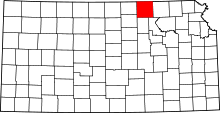 | |
| Unincorporated communities | ||
| Footnotes | ‡This populated place also has portions in an adjacent county or counties | |