Painsthorpe

Coordinates: 54°00′52″N 0°45′29″W / 54.014381°N 0.758116°W
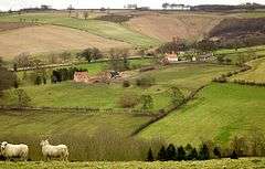
Painsthorpe is a hamlet in the East Riding of Yorkshire, England.
It is located about 1 mile (1.6 km) east of the village of Kirby Underdale, the area is remote – the nearest settlement of any size is the small town of Pocklington some 5 miles (8 km) to the south. It forms part of the civil parish of Kirby Underdale and was the site of Painsthorpe Abbey, an Anglican Benedictine monastery.
References
- Gazetteer — A–Z of Towns Villages and Hamlets. East Riding of Yorkshire Council. 2006. p. 9.
External links
| Wikimedia Commons has media related to Painsthorpe. |
- Painsthorpe in the Domesday Book
This article is issued from Wikipedia - version of the 11/20/2016. The text is available under the Creative Commons Attribution/Share Alike but additional terms may apply for the media files.