Page, Minneapolis
| Page | |
|---|---|
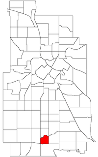 Location of Page within the U.S. city of Minneapolis | |
| Country | United States |
| State | Minnesota |
| County | Hennepin |
| City | Minneapolis |
| Community | Nokomis |
| Area[1] | |
| • Total | 0.331 sq mi (0.86 km2) |
| Population (2010)[2] | |
| • Total | 1,730 |
| • Density | 5,200/sq mi (2,000/km2) |
| Time zone | CST (UTC-6) |
| • Summer (DST) | CDT (UTC-5) |
| ZIP code | 55417, 55419 |
| Area code(s) | 612 |
| Historical population | |||
|---|---|---|---|
| Census | Pop. | %± | |
| 1980 | 1,816 | — | |
| 1990 | 1,742 | −4.1% | |
| 2000 | 1,682 | −3.4% | |
| 2010 | 1,730 | 2.9% | |
Page is a neighborhood in the Nokomis community in Minneapolis. Its boundaries are the Minnehaha Creek to the north, Chicago Avenue to the east, Diamond Lake Road and East 55th Street to the south, and Interstate 35W to the west. Page shares a neighborhood organization with the Hale and Diamond Lake neighborhoods. Coordinates: 44°54′28″N 93°16′11″W / 44.9077°N 93.2696°W[3]
References
- ↑ "Page neighborhood in Minneapolis, Minnesota (MN), 55417, 55419 detailed profile". City-Data. 2011. Retrieved 2013-11-17.
- ↑ "Minneapolis Neighborhood Profile: Page" (PDF). Minnesota Compass. October 2011. Retrieved 2013-11-14.
- ↑ Page, Minneapolis, MN. Google Earth. Retrieved 2011-03-09.
External links
- Minneapolis Neighborhood Profile - Page
- Hale-Page-Diamond Lake Community Association
- West Page Neighborhood Network
 |
Field | | ||
| Tangletown | |
Hale | ||
| ||||
| | ||||
| Diamond Lake |
This article is issued from Wikipedia - version of the 10/10/2016. The text is available under the Creative Commons Attribution/Share Alike but additional terms may apply for the media files.