Pactola Dam
| Pactola Dam | |
|---|---|
 | |
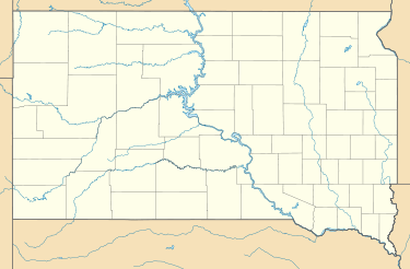 Location of Pactola Dam in South Dakota | |
| Country | United States |
| Location | Pennington County, South Dakota |
| Coordinates | 44°04′16″N 103°29′10″W / 44.07111°N 103.48611°WCoordinates: 44°04′16″N 103°29′10″W / 44.07111°N 103.48611°W |
| Status | Operational |
| Construction began | 1952 |
| Opening date | 1956 |
| Owner(s) | U.S. Bureau of Reclamation |
| Dam and spillways | |
| Type of dam | Embankment |
| Impounds | Rapid Creek |
| Height | 230 ft (70 m) |
| Length | 2,236 ft (682 m) |
| Elevation at crest | 4,655 ft (1,419 m) |
| Spillway capacity | 245,000 cu ft/s (6,938 m3/s) |
| Reservoir | |
| Creates | Pactola Lake |
| Total capacity |
Total: 99,000 acre·ft (122,114,702 m3) Flood storage:43,000 acre·ft (53,039,719 m3) |
| Normal elevation | 4,580 ft (1,396 m) |
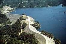
Pactola Dam is an embankment dam on Rapid Creek in Pennington County, South Dakota. The purpose of the dam is flood control, water supply and recreation. The dam was approved by the Flood Control Act of 1944 and construction began on November 25, 1952 and the dam was complete on August 15, 1956.[1]
The dam and reservoir are part of the Rapid Valley Unit, along with the nearby Deerfield Dam. The dam is 230 ft (70 m) tall and 1,225 ft (373 m) long while the dam and its auxiliary dams are 2,236 ft (682 m) long. The dam has an uncontrolled overflow spillway with a maximum discharge capacity of 245,000 cu ft/s (6,938 m3/s). Total reservoir water storage is 99,000 acre·ft (122,114,702 m3) while 43,000 acre·ft (53,039,719 m3) of that is for flood control.[2]
References
- ↑ "Pactola Dam". U.S. Bureau of Reclamation. Retrieved 19 June 2011.
- ↑ "Rapid Valley Unit". U.S. Bureau of Reclamation. Retrieved 19 June 2011.