Patiala and East Punjab States Union
| Patiala and East Punjab States Union (PEPSU) ਪੈਪਸੂ | |||||
| State of India | |||||
| |||||
.svg.png) | |||||
| {{#if:Patiala| | Capital | Patiala | |||
| Government | Democracy | ||||
| Legislature | PEPSU Legislative Assembly | ||||
| History | |||||
| • | State Established | 15 July 1948 1948 | |||
| • | State Disestablished | 1 November 1956 1956 | |||
| Area | |||||
| • | 1951 | 26,208 km2 (10,119 sq mi) | |||
| Population | |||||
| • | 1951 | 3,493,685 | |||
| Density | 133.3 /km2 (345.3 /sq mi) | ||||
The Patiala and East Punjab States Union (PEPSU) was a state of India between 1948 and 1956. It was created by combining eight princely states: Patiala, Jind, Nabha, Kapurthala, Faridkot, Kalsia, Malerkotla and Nalagarh. The state was inaugurated on July 15, 1948 and formally became a state of India in 1950. The capital and principal city was Patiala. The state covered an area of 26,208 km². Shimla, Kasauli, Kandaghat, Dharampur and Chail also became part of the PEPSU.
History
When the state was formed, the then-Maharaja of Patiala, Yadavindra Singh, was appointed its Rajpramukh (equivalent to Governor). He remained in office during the entire length of the state's short existence. The then Maharaja of Kapurthala, Jagatjit Singh served as Uparajpramukh. While inaugurating Patiala and East Punjab States Union (PEPSU) with the Patiala ruler as the Rajpramukh, Vallabhbhai Patel said, "If I were to be born again I shall like to take be born as a loyal subject of the Maharajadhiraj of Patiala."
Gian Singh Rarewala was sworn in on 13 January 1949 as the first Chief Minister of PEPSU. Col. Raghbir Singh became the next Chief Minister on 23 May 1951, and Brish Bhan the Deputy Chief Minister.
The state elected a 60-member state legislative assembly on January 6, 1952. The Congress Party won 26 seats and the Akali Dal won 19 seats.
On 22 April 1952, Gian Singh Rarewala again became Chief Minister, this time an elected one. He led a coalition government, called the "United Front", formed by the Akali Dal and various independents. On 5 March 1953 his government was dismissed and President's rule was imposed on the state.[1] In the mid-term poll that followed, the Congress party secured a majority and Raghbir Singh became Chief Minister on 8 March 1954. Upon his death, Brish Bhan became the Chief Minister on 12 January 1955 and remained in office until 1 November 1956, when PEPSU was merged mostly into Punjab State following the States Reorganisation Act.[2]
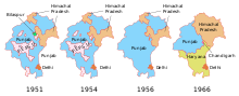
A part of the former state of PEPSU, including the south-eastern portion around Jind and the Narnaul enclave, presently lie within the state of Haryana, which was separated from Punjab on 1 November 1966. Some other areas that belonged to PEPSU, notably Solan and Nalagarh, now lie in the state of Himachal Pradesh.
Subdivisions
Initially, in 1948, the state was divided into the following eight districts:
- Patiala district
- Barnala district
- Bhatinda district
- Fatehgarh district
- Sangrur district
- Kapurthala district
- Mohindergarh district
- Kohistan district
In 1953, the number of districts was reduced from eight to five. Barnala district became part of Sangrur district and Kohistan and Fatehgarh districts became part of Patiala district.[3]
There were four Lok Sabha constituencies in this state. Three of them were single-seat constituency: Mohindergarh, Sangrur and Patiala. The Kapurthala-Bhatinda Lok Sabha constituency was a double-seat constituency.
Demography
The state had a population of 3,493,685 (1951 census), of which 19% was urban. The population density was 133/km².[4]
References
- ↑ Singh, Roopinder (16 December 2001). "Rarewala: A Punjabi-loving gentleman-aristocrat". The Tribune.
- ↑ "States Reorganisation Act, 1956". India Code Updated Acts. Ministry of Law and Justice, Government of India. 31 August 1956. pp. section 9. Retrieved 16 May 2013.
- ↑ "History of Jind district". Jind district website. Retrieved 19 March 2011.
- ↑ "Patiala and East Punjab States Union". The Sikh Encyclopedia. Retrieved 11 Nov 2016.
Further reading
- Singh, Gursharan (1991). History of PEPSU, India: Patiala and East Punjab States Union, 1948-1956, Delhi: Konark Publishers, ISBN 81-220-0244-7.
Coordinates: 31°27′N 77°36′E / 31.45°N 77.60°E
| Part A States | ||
|---|---|---|
| Part B States | ||
| Part C States | ||
| Part D States | ||