Oued El Alenda
| Oued El Alenda وادى اﻟﻌﻠﻨﺪة | |
|---|---|
| Commune and town | |
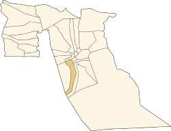 Location of Oued El Alenda commune within El Oued Province | |
 Oued El Alenda Location of Oued El Alenda within Algeria | |
| Coordinates: DZ 33°13′44″N 6°45′26″E / 33.22889°N 6.75722°ECoordinates: DZ 33°13′44″N 6°45′26″E / 33.22889°N 6.75722°E | |
| Country |
|
| Province | El Oued Province |
| District | Mih Ouensa District |
| Elevation | 95 m (312 ft) |
| Population (2008) | |
| • Total | 6,830 |
| Time zone | CET (UTC+1) |
Oued El Alenda (Arabic: وادى اﻟﻌﻠﻨﺪة) is a town and commune in Mih Ouensa District, El Oued Province, Algeria. According to the 2008 census it has a population of 6,830,[1] up from 5,839 in 1998,[2] with an annual growth rate of 1.6%.[1] The town is 17 kilometres (11 mi) southwest of the provincial capital El Oued, on the N16 highway connecting it to Touggourt.
Climate
Oued El Alenda has a hot desert climate (Köppen climate classification BWh), with very hot summers and mild winters. Rainfall is light and sporadic, and summers are particularly dry.
Education
4.3% of the population has a tertiary education, and another 13.0% has completed secondary education.[3] The overall literacy rate is 75.5%, and is 83.2% among males and 67.2% among females.[4]
Localities
The commune of Oued El Alenda is composed of seven localities:[5]
References
- 1 2 "Population: El Oued Wilaya" (PDF) (in French). Office National des Statistiques Algérie. Retrieved 12 February 2013.
- ↑ "Algeria Communes". Statoids. Retrieved 9 March 2013.
- ↑ "Structure relative de la population résidente des ménages ordinaires et collectifs âgée de 6 ans et plus selon le niveau d'instruction et la commune de résidence." (PDF) (in French). Office National des Statistiques Algérie. Retrieved 13 February 2013.
- ↑ "Taux d'analphabétisme et taux d'alphabétisation de la population âgée de 15 ans et plus, selon le sexe et la commune de résidence ." (PDF) (in French). Office National des Statistiques Algérie. Retrieved 13 February 2013.
- ↑ "Décret n° 84-365, fixant la composition, la consistance et les limites territoriale des communes. Wilaya d'El Oued" (PDF) (in French). Journal officiel de la République Algérienne. 19 December 1984. p. 1564. Archived from the original (PDF) on 2 March 2013 or before. Retrieved 2 March 2013. Check date values in:
|archive-date=(help)
 |
Djamaa | Ourmas | El Oued Bayadha Robbah |
|
| Oudeï Tork Touggourt |
|
Chégamat El Ogla | ||
| ||||
| | ||||
| Mih Ouensa | Dabadib Hassi Messaoud (Ouargla) Illizi |
El Borma |
