Ottawa, Wisconsin
| Ottawa, Wisconsin | |
|---|---|
| Town | |
|
Town hall | |
 Location in Waukesha County and the state of Wisconsin. | |
| Coordinates: 42°58′25″N 88°27′44″W / 42.97361°N 88.46222°W | |
| Country | United States |
| State | Wisconsin |
| County | Waukesha |
| Area | |
| • Total | 34.9 sq mi (90.4 km2) |
| • Land | 34.3 sq mi (88.9 km2) |
| • Water | 0.6 sq mi (1.6 km2) |
| Elevation[1] | 856 ft (261 m) |
| Population (2000) | |
| • Total | 3,758 |
| • Density | 109.5/sq mi (42.3/km2) |
| Time zone | Central (CST) (UTC-6) |
| • Summer (DST) | CDT (UTC-5) |
| FIPS code | 55-60700[2] |
| GNIS feature ID | 1583880[1] |

Ottawa is a town in Waukesha County, Wisconsin, United States. The population was 3,758 at the 2000 census. The unincorporated community of Ottawa is located in the town.
History
The town is named after the Ottawa, a Native American tribe.[3]
Geography
According to the United States Census Bureau, the town has a total area of 34.9 square miles (90.4 km²), of which, 34.3 square miles (88.9 km²) of it is land and 0.6 square miles (1.6 km²) of it (1.75%) is water.
Demographics
| Historical population | |||
|---|---|---|---|
| Census | Pop. | %± | |
| 1980 | 2,795 | — | |
| 1990 | 2,988 | 6.9% | |
| 2000 | 3,758 | 25.8% | |
| 2010 | 3,859 | 2.7% | |
As of the census[2] of 2000, there were 3,758 people, 1,375 households, and 1,112 families residing in the town. The population density was 109.5 people per square mile (42.3/km²). There were 1,436 housing units at an average density of 41.8 per square mile (16.2/km²). The racial makeup of the town was 98.06% White, 0.27% African American, 0.40% Native American, 0.24% Asian, 0.37% from other races, and 0.67% from two or more races. Hispanic or Latino of any race were 0.72% of the population.
There were 1,375 households out of which 36.3% had children under the age of 18 living with them, 74.0% were married couples living together, 3.9% had a female householder with no husband present, and 19.1% were non-families. 16.2% of all households were made up of individuals and 9.2% had someone living alone who was 65 years of age or older. The average household size was 2.73 and the average family size was 3.06.
In the town the population was spread out with 26.4% under the age of 18, 5.8% from 18 to 24, 26.6% from 25 to 44, 29.7% from 45 to 64, and 11.4% who were 65 years of age or older. The median age was 41 years. For every 100 females there were 100.1 males. For every 100 females age 18 and over, there were 99.8 males.
The median income for a household in the town was $69,493, and the median income for a family was $71,850. Males had a median income of $51,886 versus $35,825 for females. The per capita income for the town was $30,977. About 0.7% of families and 1.7% of the population were below the poverty line, including 0.2% of those under age 18 and 1.0% of those age 65 or over.
Notable people
- Caleb C. Harris, physician and politician, lived in the town.[4]
References
- 1 2 "US Board on Geographic Names". United States Geological Survey. 2007-10-25. Retrieved 2008-01-31.
- 1 2 "American FactFinder". United States Census Bureau. Retrieved 2008-01-31.
- ↑ "Approach of the White Man." History of Milwaukee. Chicago: The Western Historical Company, 1881. pp. 33-55.
- ↑ 'Dr. C. C. Harris Dead,' Waukesha Freeman, September 29, 1904, pg. 1
External links
Municipalities and communities of Waukesha County, Wisconsin, United States | ||
|---|---|---|
| Cities | 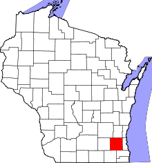 | |
| Villages | ||
| Towns | ||
| CDP | ||
| Unincorporated communities | ||
| Ghost towns | ||
| Footnotes | ‡This populated place also has portions in an adjacent county or counties | |
| Central city | 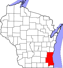 | |
|---|---|---|
| Largest municipalities (over 25,000 in 2010) | ||
| Municipalities (over 10,000 in 2010) | ||
| Smaller municipalities (under 10,000 in 2010) | ||
| Counties | ||
Coordinates: 42°58′34″N 88°26′59″W / 42.97611°N 88.44972°W