Otselic, New York
| Otselic, New York | |
|---|---|
| Town | |
|
U.S. Post Office (Dew Drop Building), South Otselic, November 2010 | |
 Otselic Location within the state of New York | |
| Coordinates: 42°41′29″N 75°44′11″W / 42.69139°N 75.73639°W | |
| Country | United States |
| State | New York |
| County | Chenango |
| Government | |
| • Type | Town Council |
| • Town Supervisor | Evan Williams (R) |
| • Town Council |
Members' List
|
| Area | |
| • Total | 38.0 sq mi (98.5 km2) |
| • Land | 38.0 sq mi (98.4 km2) |
| • Water | 0.08 sq mi (0.2 km2) |
| Elevation | 1,650 ft (503 m) |
| Population (2010) | |
| • Total | 1,054 |
| • Density | 28/sq mi (10.7/km2) |
| Time zone | Eastern (EST) (UTC-5) |
| • Summer (DST) | EDT (UTC-4) |
| FIPS code | 36-55717 |
| GNIS feature ID | 0979330 |

Otselic is a town in Chenango County, New York, United States, situated on the north border of Chenango County, northwest of the city of Norwich. The population of the town was 1,054 at the 2010 census.[1] The town is named after a river flowing through it, the Otselic, which is an Oneida word for "place of wild plums". The Otselic valley is the predominant geographic feature in the town, connecting it to the surrounding region north and south.
History
The first settler arrived around 1800. Many of the original settlers came from Connecticut. The town of Otselic was founded in 1817 from part of the town of German.[2] The year 1833 was notable for a tornado that passed over the town and measured over a mile in width.
Geography
According to the United States Census Bureau, the town has a total area of 38.0 square miles (98.5 km2), of which 38.0 square miles (98.4 km2) is land and 0.08 square miles (0.2 km2), or 0.18%, is water.[1]
Over 10 square miles (26 km2) or about 7,000 acres (2,800 ha) are state-owned forest lands dedicated to the production of forest products and open to the public for forest-related recreation such as hunting, camping, fishing, hiking and cross country skiing.
The highest altitude is just over 2,000 feet (610 m) above sea level along the south town line, rising from the lowest elevation of about 1,200 feet (370 m) at the bottom of the Otselic Valley.
The north town line is the border of Madison County.
The Otselic River (sometimes "Otselic Creek") runs through the town and later flows into the Tioughnioga River as part of the Susquehanna River watershed of Chesapeake Bay.
New York State Route 26 intersects New York State Route 80 at Otselic hamlet.
Wildlife
Formerly most of the land was in agriculture, chiefly dairy. Since the end of the nineteenth century, farm abandonment has increased, and today forest cover and early succession forest regrowth dominate the landscape mixed with remaining dairy farms. The forest cover is mixed hardwoods (maple, cherry, ash, beech, basswood, birch and hemlock[3]) occurring naturally and large plantations of spruce and pine on state-owned lands. White pine was common prior to European settlement, but due to the high demand for its clear, light, easily worked lumber, pine stands were removed during the nineteenth century and today are almost totally absent. Logging has always been an important part of the local economy, utilizing high-value hardwoods for sawlogs as well as firewood and softwood poles and pulp.
Hunting, trapping and wildlife-related recreation such as birdwatching and wildlife viewing are important activities. Common wildlife include white-tailed deer, beaver, mink, muskrat, squirrel, chipmunk, coyote, fox, skunk, raccoon, porcupine, and woodchuck, and less common but increasingly sighted wildlife include bear, otter, fisher, and bobcat. Bird life is varied and rich. Turkey and grouse are plentiful and are popular game birds. During the summer breeding season, the Otselic area has over 100 breeding bird species, one of the highest numbers of breeding bird species in New York state. Bald eagles and osprey are seen regularly along the Otselic River.[4] Ravens are recolonizing the hills, reclaiming their historic range. Red and white crossbills from Canada and Alaska have bred in the large conifer plantations on New York state land.
Demographics
| Historical population | |||
|---|---|---|---|
| Census | Pop. | %± | |
| 1820 | 526 | — | |
| 1830 | 1,238 | 135.4% | |
| 1840 | 1,621 | 30.9% | |
| 1850 | 1,800 | 11.0% | |
| 1860 | 1,752 | −2.7% | |
| 1870 | 1,733 | −1.1% | |
| 1880 | 1,512 | −12.8% | |
| 1890 | 1,284 | −15.1% | |
| 1900 | 1,234 | −3.9% | |
| 1910 | 1,104 | −10.5% | |
| 1920 | 996 | −9.8% | |
| 1930 | 880 | −11.6% | |
| 1940 | 905 | 2.8% | |
| 1950 | 896 | −1.0% | |
| 1960 | 854 | −4.7% | |
| 1970 | 925 | 8.3% | |
| 1980 | 955 | 3.2% | |
| 1990 | 990 | 3.7% | |
| 2000 | 1,001 | 1.1% | |
| 2010 | 1,054 | 5.3% | |
| Est. 2014 | 1,036 | [5] | −1.7% |
As of the census[7] of 2010, there were 1,054 people. Today's population is about half of what it was in 1875. 356 households, and 259 families reside in the town. The population density was 26.3 people per square mile (10.2/km²). There were 484 housing units at an average density of 12.7 per square mile (4.9/km²). The racial makeup of the town was 98.70% White, 0.50% Native American, 0.10% Asian, 0.10% from other races, and 0.60% from two or more races. Hispanic or Latino of any race were 1.40% of the population.
There were 356 households out of which 36.0% had children under the age of 18 living with them, 54.2% were married couples living together, 11.2% had a female householder with no husband present, and 27.0% were non-families. 19.9% of all households were made up of individuals and 9.0% had someone living alone who was 65 years of age or older. The average household size was 2.81 and the average family size was 3.15.
In the town the population was spread out with 31.8% under the age of 18, 7.8% from 18 to 24, 26.9% from 25 to 44, 23.1% from 45 to 64, and 10.5% who were 65 years of age or older. The median age was 34 years. For every 100 females there were 101.0 males. For every 100 females age 18 and over, there were 101.5 males.
The median income for a household in the town was $32,308, and the median income for a family was $34,886. Males had a median income of $30,298 versus $20,625 for females. The per capita income for the town was $14,105. About 11.2% of families and 16.0% of the population were below the poverty line, including 20.9% of those under age 18 and 10.2% of those age 65 or over.
Communities and locations in Otselic
- Beaver Meadow – A hamlet in the southeast part of the town, located on County Road 16. The name is derived from low-lying ground often flooded due to beaver dams.
- Mariposa – The settled area west of the hamlet of South Otselic along County Road 13.
- Otselic – The hamlet of Otselic is the first settled area of the town near the north town line at the junction of NY Route 26 and NY Route 80. The Otselic River passes close to the community.
- Otselic Center – A hamlet between Otselic village and Seventh Day Hollow on NY-26 at its juncture with County Road 16.
- Rhode Island – A location by the west town line.
- Sandersonville– A location of residences along NY State Hwy 26 south of the South Otselic Fish Hatchery so named for the original Sanderson Farm located there.
- Seventh Day Hollow – A hamlet northeast of South Otselic on NY-26, so named for the original settlement and church there of Seventh Day Baptists.
- South Otselic – A hamlet in the southwest corner of the town on NY-26 and the Otselic River at the junction with County Road 13. It was home to internationally known Gladding Fishing Line and is also the resting place of Grace Brown. In 1983, many of its historic buildings were included in the South Otselic Historic District on the National Register of Historic Places.[8] The Newton Homestead was listed in 1982 and the Holden B. Mathewson House, which is now a bed and breakfast, in 2009.[8]
- South Otselic State Fish Hatchery – A fish hatchery south of South Otselic.
- Stanbro – A former hamlet northwest of Beaver Meadow.
- Upper Beaver Meadow – A former location north of Beaver Meadow.
Notable people
- George W. Ray, former US congressmam
References
- 1 2 "Geographic Identifiers: 2010 Demographic Profile Data (G001): Otselic town, Chenango County, New York". U.S. Census Bureau, American Factfinder. Retrieved November 21, 2014.
- ↑ Van Ness, William Peter; Woodworth, John; Elisha B. Strong; John Van Ness Yates (1818). Laws of the State of New-York: Revised and Passed at the Thirty-sixth Session of the Legislature: with Marginal Notes and References. H.C. Southwick & Company. p. 115.
- ↑ Spafford, Horatio Gates (1824). A Gazetteer of the State of New York. B. D. Packard. p. 493.
- ↑ Bowers, Bill; McNulty-Bowers, Eileen (14 June 2010). Explorer's Guide 50 Hikes in Central New York's Leatherstocking Country (Explorer's 50 Hikes). Countryman Press. p. 160. ISBN 978-1-58157-749-5.
- ↑ "Annual Estimates of the Resident Population for Incorporated Places: April 1, 2010 to July 1, 2014". Retrieved June 4, 2015.
- ↑ "Census of Population and Housing". Census.gov. Retrieved June 4, 2015.
- ↑ "American FactFinder". United States Census Bureau. Retrieved 2008-01-31.
- 1 2 National Park Service (2009-03-13). "National Register Information System". National Register of Historic Places. National Park Service.
External links
Coordinates: 42°43′21″N 75°43′12″W / 42.72250°N 75.72000°W
Municipalities and communities of Chenango County, New York, United States | ||
|---|---|---|
| City | 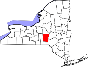 | |
| Towns | ||
| Villages | ||
| CDPs | ||
| Hamlets | ||
| Footnotes | ‡This populated place also has portions in an adjacent county or counties | |