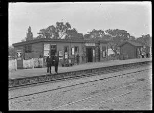
Otorohanga Railway Station
Otorohanga railway station | ||||||||||||||||
|---|---|---|---|---|---|---|---|---|---|---|---|---|---|---|---|---|
 | ||||||||||||||||
| Location | New Zealand | |||||||||||||||
| Coordinates | 38°11′12″S 175°12′44″E / 38.1867°S 175.2123°ECoordinates: 38°11′12″S 175°12′44″E / 38.1867°S 175.2123°E | |||||||||||||||
| Line(s) | North Island Main Trunk | |||||||||||||||
| History | ||||||||||||||||
| Opened | 9 March 1887[1] | |||||||||||||||
| Closed | 2012[2] | |||||||||||||||
| Electrified | June 1988 | |||||||||||||||
| Services | ||||||||||||||||
| ||||||||||||||||
Otorohanga Railway Station has served the town of Otorohanga, on the North Island Main Trunk in New Zealand since 1887. It was 4.45 km (2.77 mi) south of Kiokio and 9.21 km (5.72 mi) north of Hangatiki,[3] but is now one of only 9 stations on the line served by the Northern Explorer.[4]
Trains calling at Otorohanga included The Overlander, Blue Streak, Scenic Daylight, Daylight Limited, Northerner and Night Limited. By 2012 passenger numbers had dropped to an average of two per train,[5] which brought about a brief closure from 24 June.[6] Initially the reinstatement was for summer only[7] from 10 December[8]
Services
The station is managed by Kiwirail who operate the Northern Explorer three times a week in each direction between Wellington and Britomart. Hamilton is 48.11 km (29.89 mi) to the north, timetabled in 2015, departure to departure, in 39 minutes, and National Park, 147.58 km (91.70 mi)[3] to the south, in 139 minutes, both southbound.[4]
| Preceding station | Historical railways | Following station | ||
|---|---|---|---|---|
| Kiokio Line open, station closed |
North Island Main Trunk New Zealand Railways Department |
Hangatiki Line open, station closed | ||
Rangitoto Colliery Co. branch


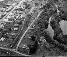
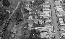
The 1919 Railways Authorisation Bill included a, "branch line from Otorohanga, along right bank of the Waipa River, to the south boundary of Block VI, Mangaoronga survey district. Length about 7½ miles."[9] The Railway Atlas indicates the line was horse worked, served the Ellis and Burnand Mill, as well as the colliery, and existed by 1921.[3] The 1921 photograph (left) appears to show a horse worked tramway, but only remnants of the line appear in the 1947 photos.
A 1944 Parliamentary report indicates the colliery had closed some time before and that a road was built, rather than using the tramway. The report said, "Rangitoto Opencast.—Stripping of this area, adjacent to the old Rangitoto Colliery, some eight miles from Otorohanga, commenced, in July. An access road was also constructed. Coal-production started in September, Output for 1944 was 1,797 tons."[10]
References
- ↑ Juliet Scoble: Names & Opening & Closing Dates of Railway Stations in New Zealand
- ↑ Otorohanga DC minutes p. 10
- 1 2 3 New Zealand Railway and Tramway Atlas (First ed.). Quail Map Co. 1965. pp. 3 & 4.
- 1 2 KiwiRail Scenic Journeys - Northern Explorer
- ↑ Waikato Times 19 May 2012 Kiwirail reviews axing of Otorohanga stop
- ↑ Waikato Times 19 June 2012
- ↑ NZ Herald 26 June 2012,
- ↑ KiwiRail staff magazine
- ↑ Taranaki Daily News , 24 October 1919, Page 4
- ↑ Appendix to the Journals of the House of Representatives, 1945 Session I, C-02 statement by the acting Minister of Mines p. 25
External links
- New Zealand Herald, Volume XXIV, Issue 7844, 13 January 1887, Page 5 progress report on NIMT construction and the effect on Otorohanga
- Waikato Times, Volume XXIII, Issue 2271, 29 January 1887, Page 3 construction of goods shed and station by Mr Worthington expected to be complete a few weeks after the line opened
- Auckland Weekly News photo 11 June 1898 p4 (AWNS-18980611-4-4)
- Taranaki Daily News, Volume LV, Issue 306, 19 May 1913, Page 4 shunter's death