Osteel
| Osteel | ||
|---|---|---|
 | ||
| ||
 Osteel | ||
Location of Osteel within Aurich district 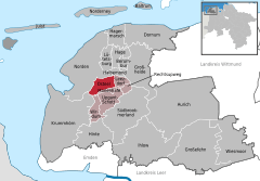
 | ||
| Coordinates: 53°32′N 7°16′E / 53.533°N 7.267°ECoordinates: 53°32′N 7°16′E / 53.533°N 7.267°E | ||
| Country | Germany | |
| State | Lower Saxony | |
| District | Aurich | |
| Municipal assoc. | Brookmerland | |
| Government | ||
| • Mayor | Burkhard Heuer (SPD) | |
| Area | ||
| • Total | 19.9 km2 (7.7 sq mi) | |
| Population (2015-12-31)[1] | ||
| • Total | 2,211 | |
| • Density | 110/km2 (290/sq mi) | |
| Time zone | CET/CEST (UTC+1/+2) | |
| Postal codes | 26529 | |
| Dialling codes | 04920, 04931, 04934 (mainly) | |
| Vehicle registration | AUR | |

Osteel is a municipality in the district of Aurich, in Lower Saxony, Germany.
History
The village was first mentioned in 1164 . The early settlement was on the edge of a moor.
The arms of the municipality shows a golden crown at the top on a blue background. In the centre is a golden hammer. Left and right of each is a golden trifoliate clover . The clovers point to the agricultural sector.
Attractions

A landmark of the village is Warnfried Church, dated to the 12th Century. The church has a length of 63 meters and is dedicated to Werenfried. The Organ of the Church is the second oldest in Ostfriesland. It was built in 1619 by Master Edo Evers.
Outside the church stands the monument of the astronomer David Fabricius. From him not only stars were discovered, but he also drew one of the first maps of East Frisia. His son Johann discovered the sunspots.
Transport
The main town is on the Osteel Bundesstraße 72 about six miles south of the old town. Railway lines connect it to Emden. After the closure of the station in 1978, the next station is now in three km south at Marienhafe .
Notable people
- David Fabricius (1564–1617), astronomer
- Johannes Fabricius (1587–1617), astronomer
- Friedrich Vissering (1826–1885), Reichstagsabgeordneter
- Dirk Agena, (1889–1934), Politician and Reichstagsabgeordneter
- Siemen Rühaak (1950-), actor
References
External links
| Wikimedia Commons has media related to Osteel. |
Towns and municipalities in Aurich (district) | ||
|---|---|---|